Category: Forecast Models

Sunday Afternoon Update: Awesome Stretch Of Weather Before Dramatic Changes.

Good Sunday afternoon!  We’re enjoying beautiful weather and conditions will only improve Monday into Tuesday.  That said, a potential winter storm looms Wednesday.  Additionally, we’re keeping a close eye on…

You must be logged in to view this content. Click Here to become a member of IndyWX.com for full access.  Already a member of IndyWx.com All-Access?  Log-in here.

Permanent link to this article: https://indywx.com/sunday-afternoon-update-awesome-stretch-of-weather-before-dramatic-changes/

Saturday Morning Thoughts…

Good morning and happy Saturday!  A weak weather system will move through the region and produce a couple of light showers this afternoon, but won’t be a big deal.  Rain will end as a couple of snow flakes.  Overall precipitation totals look less and less impressive with each model run, which wasn’t impressive to begin with.  Needless to say, don’t be concerned by any sort of significant rain or snow today.

Latest simulated radar off the NAM and HRRR shows the band of light precipitation pushing through the state this afternoon.

hrrr_ref_indy_12nam_ptype_slp_mc_7

While we’ll have a brief “set back” in the temperature department this weekend, early next week continues to look downright mild and very spring like.  Note our region flirting with 60s.  Impressively, a budding area of 70-degree warmth is expanding to our west.

nam_t2m_max_mc_22

Details remain quite sketchy in regards to nailing down the storm the middle of next week with any sort of confidence.  While we’ll continue to sort through the data and gain a better understanding of things over the weekend, we’re confident on a colder regime returning by the middle of next week.  Note the trough per the GFS ensembles returning to the east.  Much more later!

gefs_z500anom_nh_21

Permanent link to this article: https://indywx.com/saturday-morning-thoughts/

Beauty Of A Close To The Work Week…

Fri.

Sat.

Sun.

Mon.

Tue.

Wed.

Thr.

 Status-weather-clouds-icon

 Status-weather-showers-scattered-icon

 Status-weather-clouds-icon

 Status-weather-clouds-icon

 Status-weather-clouds-icon

 Status-weather-snow-scattered-icon

 Status-weather-clouds-icon

21/ 53

30/ 46

21/ 45

33/ 60

40/ 61

21/ 40

13/ 32

– – –

Light

– – –

– – –

– – –

Light

– – –

Forecast Updated 03.07.14 @ 7:30a

Get Outside & Enjoy…We’re going to wrap up the work week with beautiful conditions.  If you can get out of work or school early today, IndyWx.com highly recommends it :-)!  High pressure will support sunny skies (after a little morning fog in spots) and milder temperatures.  Highs will zoom into the lower to middle 50s this afternoon!

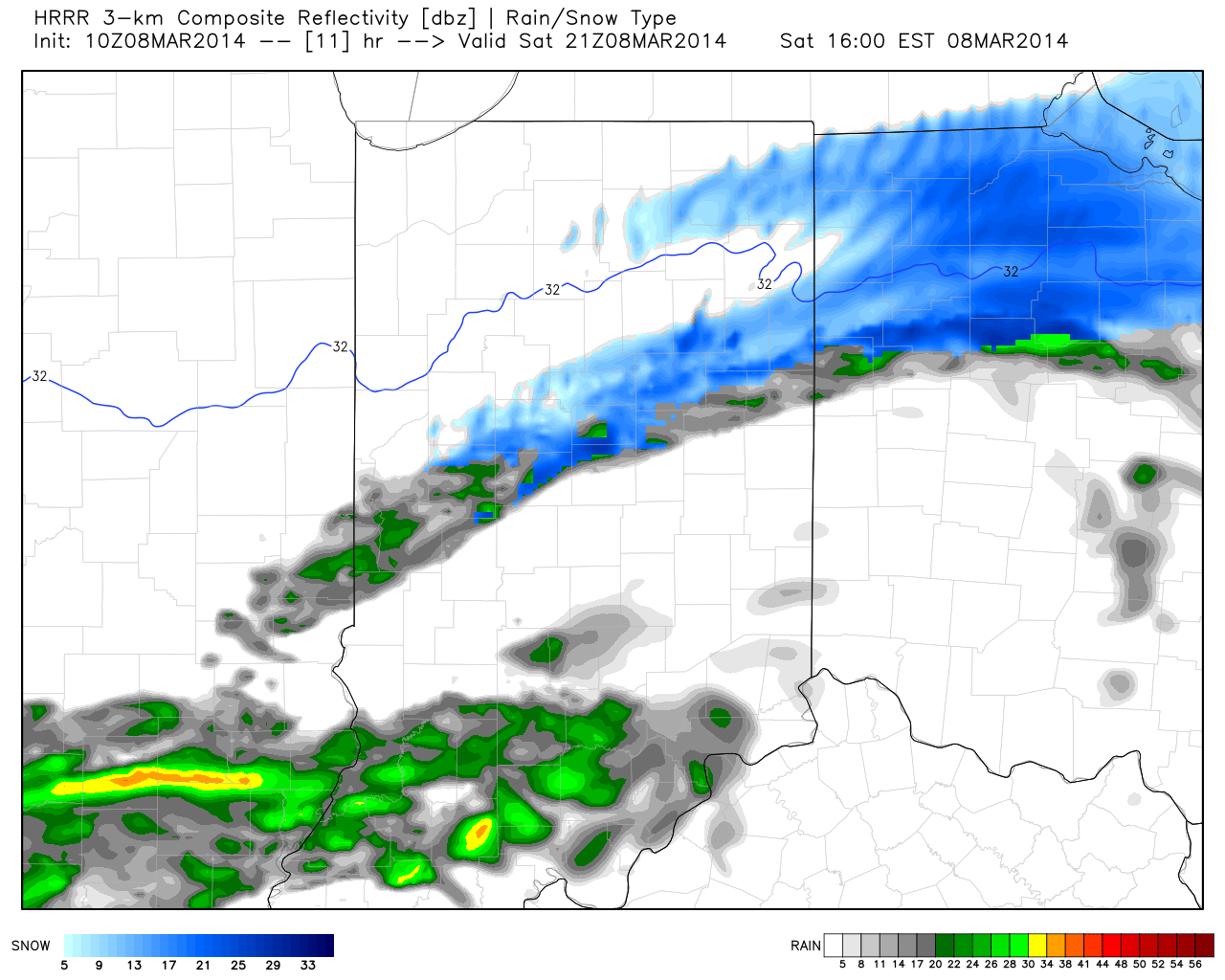
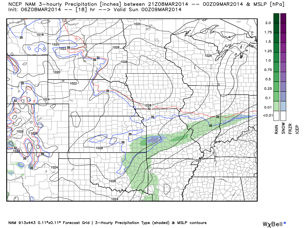
Weak Weekend System…A weak cold front will slip south through the region Saturday.  Early morning sunshine will quickly give way to increasing clouds and developing light rain.  Rain will end as a period of light snow Saturday evening, but won’t accumulate.  The key word in all of this is light, with rainfall totals under a tenth of an inch.

Sunday will be a dry, chilly day with highs in the middle 40s.

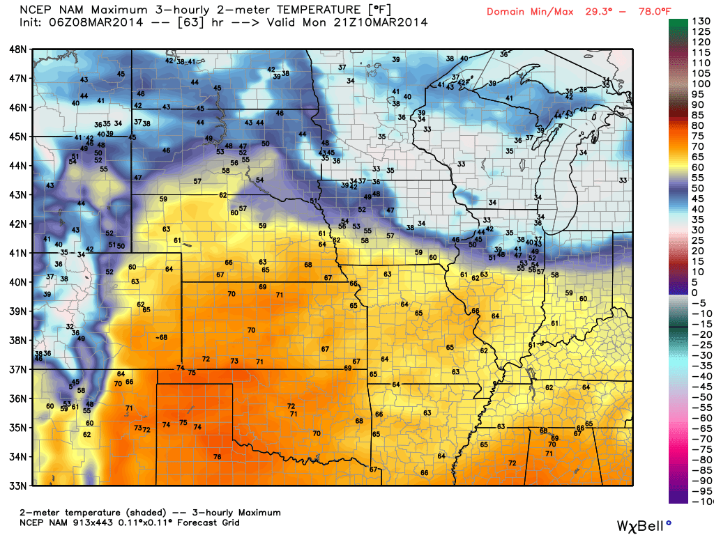
True Spring Feel…The spring crave will be in full effect early next week as highs both Monday and Tuesday shoot into the lower 60s with sunshine.  We’ll notice a gusty westerly breeze Monday, assisting with the milder surge of air into the Ohio Valley.

Late Season Winter Storm Brewing?  Many questions remain around the ultimate track of the storm system by the middle of next week.  As of now, a blend of forecast model suggests a rain-to-snow scenario Wednesday, but it’s far too early to talk accumulations.  We’ll be able to fine tune some things over the weekend and have a better idea soon in regards to precipitation type and amount.  Regardless, a much colder air mass will pour into the region by the middle of next week.

Upcoming 7-Day Precipitation Forecast:

  • 7-Day Snowfall Forecast: 1-3″
  • 7-Day Rainfall Forecast: 0.10″ – 0.25″

twic

For weather updates and more “behind the scenes” data on the go, be sure to Follow Us on Twitter @indywx or become a Friend of IndyWx.com on Facebook!

images

Permanent link to this article: https://indywx.com/beauty-of-a-close-to-the-work-week/

Thursday Evening Video Update…

Quick video update tonight to cover a couple of things: Southeast rain and western NC winter event. Beauty of a close to the work week here! More “rumblings” of a…

You must be logged in to view this content. Click Here to become a member of IndyWX.com for full access.  Already a member of IndyWx.com All-Access?  Log-in here.

Permanent link to this article: https://indywx.com/thursday-evening-video-update/

Video Update On The Mid Month Storm Brewing…

We wanted to take the time to quickly update you on a couple of very minor events in here tomorrow evening and again Saturday.  Additionally, we’re monitoring the prospects of…

You must be logged in to view this content. Click Here to become a member of IndyWX.com for full access.  Already a member of IndyWx.com All-Access?  Log-in here.

Permanent link to this article: https://indywx.com/video-update-on-the-mid-month-storm-brewing/