You must be logged in to view this content. Click Here to become a member of IndyWX.com for full access. Already a member of IndyWx.com All-Access? Log-in here.

Dec 02
You must be logged in to view this content. Click Here to become a member of IndyWX.com for full access. Already a member of IndyWx.com All-Access? Log-in here.
Permanent link to this article: https://indywx.com/video-a-cold-wintry-pattern-is-upon-us/
Nov 30
You must be logged in to view this content. Click Here to become a member of IndyWX.com for full access. Already a member of IndyWx.com All-Access? Log-in here.
Permanent link to this article: https://indywx.com/video-touching-base-on-wednesday-morning/
Nov 28
Whether or not central Indiana deals with a winter storm Sunday-Monday is up for debate, but what’s not up for debate is the likelihood of a very active and stormy pattern. We’re rolling into a new pattern right on schedule and it’s one that could produce multiple big-hitter winter storms this season. As we know, each storm system will have its’ respected challenges that will require a great deal of attention (all winter storms do), but we want to continue to stress that, eventually, the mean winter pattern is one that could (and one could easily argue “should”) yield not just one, but multiple heavy wintry impact events.
That brings us to the European model and the potential of wintry prospects for the upcoming weekend into early next week. Before we look at the current data, let’s look back at what the European’s ensemble mean printed out last Saturday. At first glance, it’s not a very “interesting” look, but understanding the European’s known bias of hanging too much energy back in the SW led us to begin raising an eyebrow for wintry “mischief” for the upcoming weekend into early parts of what was then Week 2 (12.4.16-12.5.16 time frame).
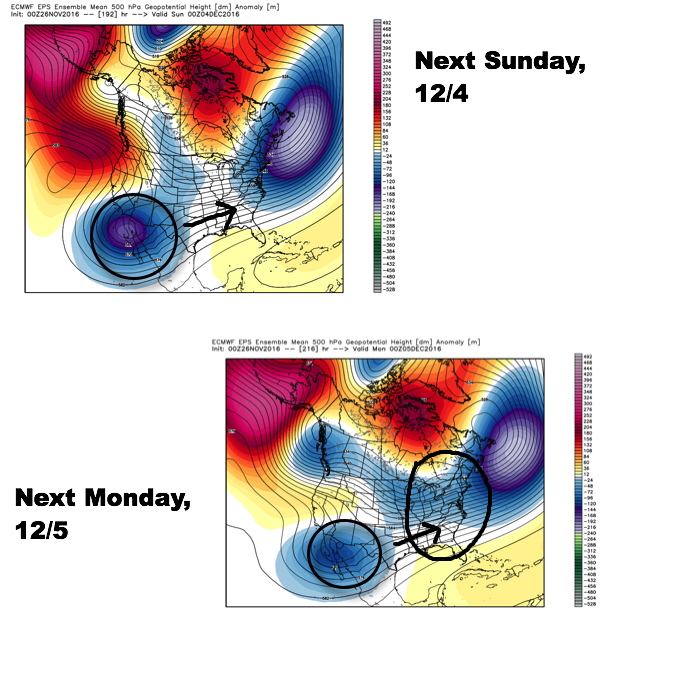 Since then, the European has begun to lock-in to a trend of bringing that SW energy out quicker and, in return, igniting a surface low to develop in the western Gulf of Mexico (GOM) Saturday before tracking northeast into the TN Valley (Sunday) and Great Lakes region (Monday).
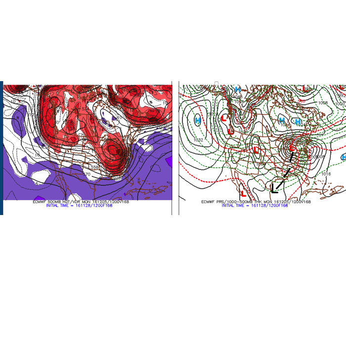 Taken verbatim, this would spread a cold rain into central IN Sunday before colder air begins to change the rain over to a wet, heavy snow Sunday night into Monday morning across central IN. Heavy, wind-blown, snow amounts would result with such a solution for portions of central IN. Such a scenario would be a high-impact event. While the majority of model data (factoring in the GFS and Canadian, for example) is far from agreeing on such a solution, it’s important to note that a trend of such a scenario is beginning to develop within the powerful European forecast model. Furthermore, roughly half of the European’s (51) ensemble members agree on an impactful winter event in the Sunday-Monday time period for central Indiana.
What could go wrong? Plenty. This is an event that’s still 6-7 days away and a subtle shift west or east with the low’s track would result in mostly a rain vs. snow event. Realizing that is as important as understanding that when the European model begins to lock-in to a trend, it’s also imperative we pay particular attention- no matter if this is an event in the short-term, or medium-range. Though far from perfect, the European model has been known to “sniff out” impactful events well before other data. Know that we’re keeping a close eye on things.
In closing, regardless if this is “the storm” that ushers in the snowy pattern we expect this year, or not, there are plenty of additional “fun and games” awaiting on deck. As mentioned previously, challenges will await with each respected storm (for example, rain-snow-mix lines). Wintry weather will likely be a news headline this Christmas season as travel plans are altered and snow removal efforts are initiated much earlier than recent winter’s past. If our idea is correct, the expected snowy December pattern is only the beginning to a busy winter…
Permanent link to this article: https://indywx.com/better-get-used-to-this-type-pattern-this-winter-a-word-on-the-european/
Nov 20
The 2016-2017 IndyWx.com Winter Outlook was posted on October 30th. If you haven’t had an opportunity to see it, you can here. Right out of the gate, we remain bullish on the prospects of a snowy holiday stretch this year, including above average snowfall for the month of December (average December snowfall at IND is 6.9″).
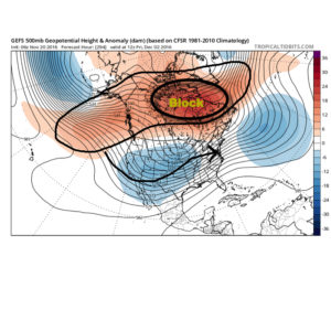
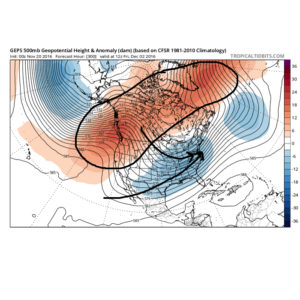
We continue to undergo that “step-down” process within the pattern, but there are growing signals that suggest the pattern takes on a very “blocky look” as we rumble into December. When we talk about a blocking pattern in this instance, we’re specifically talking about high-latitude blocking. Essentially this is when high pressure sets up in the high latitude regions (Greenland or northern Canada, for example). Textbook blocky patterns feature high pressure that sustains itself and is very persistent, leading to a “log-jam” of sorts in the weather pattern, and playing a pivotal role in locking cold, stormy weather in for lengthy periods of time across the Lower 48. Many times this is a “feedback” type scenario, meaning the early period of blocking patterns initially turns stormy and then grows progressively colder as the snowpack is laid down further and further south.
When we look at the medium-range and longer-term model data, we note the blocky pattern developing as we wrap up November and rumble into December. The European, Canadian, and GFS ensemble data all shows the stormy look evolving.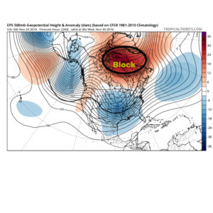
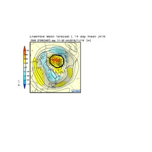
 The Weeklies also show this pattern in the longer-term. While we can’t show the European data here (due to licensing), we can show the JMAs. Again, note the high-latitude blocking.
 Active times are ahead as a busy storm track develops. Perhaps the scene for many will look a little something like this as we push into the Christmas season…
 In the meantime, gas up the snow blower and sharpen the snow shovel. If our idea is correct, a snowier than average December will come out of this blocky pattern.
Permanent link to this article: https://indywx.com/snowy-increasingly-cold-december-expected/
Nov 18
You must be logged in to view this content. Click Here to become a member of IndyWX.com for full access. Already a member of IndyWx.com All-Access? Log-in here.
Permanent link to this article: https://indywx.com/video-stormy-by-evening-much-colder-this-weekend/