Category: Forecast Models

Video Update On The Mid Month Storm Brewing…

We wanted to take the time to quickly update you on a couple of very minor events in here tomorrow evening and again Saturday.  Additionally, we’re monitoring the prospects of…

You must be logged in to view this content. Click Here to become a member of IndyWX.com for full access.  Already a member of IndyWx.com All-Access?  Log-in here.

Permanent link to this article: https://indywx.com/2014/03/04/video-update-on-the-mid-month-storm-brewing/

Cold Pattern Continues…

Tue.

Wed.

Thr.

Fri.

Sat.

Sun.

Mon.

 Status-weather-clouds-icon

 Status-weather-snow-scattered-day-icon

 Status-weather-snow-scattered-day-icon

 Status-weather-clouds-icon

 Status-weather-snow-scattered-icon

 Status-weather-clouds-icon

 Status-weather-clouds-icon

5/ 32

17/ 36

20/ 39

24/ 52

29/ 39

20/ 38

29/ 53

– – –

Light

Light

– – –

Light

– – –

– – –

Forecast Updated 03.04.14 @ 8:22a

Sunny, But Cold…Another day of bright sunshine will help temperatures rebound to the freezing mark Tuesday afternoon.  While this is still well below normal and closer to the normal low for this date of 29 degrees, it’ll be a full 14 degrees “milder” than Monday’s high.  You know it’s been a cold winter when you’re saying the freezing mark is milder for a high in March.

Weak Weather Maker…A weak clipper system will move towards the region Wednesday evening into Thursday.  While this will be an accumulating snow producer for areas to our west, current thinking still moves this moisture towards our region, but with a dry air mass in place we think precipitation starts to fall apart as it moves in.  All of that said, light snow and scattered snow showers will fall for parts of the region Wednesday night into early Thursday.  We still think most don’t deal with much, if any, accumulation, but a light coating is possible in spots.  We’ll continue to monitor.

Eyeing Another Wintry Weekend…Modeling is still far from in agreement on the evolution of things on the weekend, but the general idea is one that brings a cold front through here Friday night into early Saturday morning with a wave of low pressure moving northeast out of the middle Mississippi River Valley into the eastern Ohio Valley Saturday.  With fresh cold air oozing south, combined with the associated track of the low, this is a potentially wintry set up for the region and we’re officially calling for a wintry mixture of light snow and/ or sleet across central Indiana Saturday.  The key word is light, but it could still be enough to create a few slick spots across the region.

Briefly Milder; Tracking The Next Significant Storm…The GFS and Canadian forecast models keep our region dry during the early to middle part of next week as a surface low tracks out of the Gulf and well south and east of our region.  On the other hand, the European forecast model winds a storm up much farther north and west and presents a heavy rain and possible thunderstorm threat here by Tuesday and Wednesday of next week.  We still have time to watch this and think the European may be a little too aggressive at present, but stay tuned.

What we are confident on is a briefly milder push of air early next week that could send temperatures well into the 50s.  Don’t get used to it, however, as yet another polar plunge arrives by the mid week stretch.

Upcoming 7-Day Precipitation Forecast

  • 7-Day Snowfall Forecast: 1-2″
  • 7-Day Rainfall Forecast: Less than 0.10″

twic

For weather updates and more “behind the scenes” data on the go, be sure to Follow Us on Twitter @indywx or become a Friend of IndyWx.com on Facebook!

images

Permanent link to this article: https://indywx.com/2014/03/03/a-record-cold-start-possible/

Some Late Night Thoughts…

It’s been a long day, but we’d like nothing more than to be right here in the good ole forecast office, digging into data for our next winter storm with you.  While “part 2” of the storm remains just offshore as of this post, it’ll likely be trudging onshore by the time you read this early Saturday morning.  That said, the initial wave of accumulating snow (and for some, ice) will arrive as early as late Saturday night/ wee morning hours (well before sunrise) Sunday in the form of an overrunning event- where comparably warmer, more moist air is lifted up and overruns the cold air at the surface.

Early ideas suggest we undergo a period of moderate to heavy wintry precipitation as early as 3-ish Sunday morning, extending into the late morning hours.  Particularly, we bracket the hours of 3am to 10am Sunday for the initial wave of wintry weather.  This will be a mixed bag of precipitation, including snow, sleet, and freezing rain across central Indiana.  An early look at the high resolution simulated radar courtesy of the NAM shows this well- valid 7am Sunday morning.  Image is courtesy of the fine folks over at Weatherbell Analytics.

hires_ref_indy_37

After a “lull” in the accumulating wintry precipitation from late morning/ early afternoon Sunday, we’ll likely deal with another round of moderate to heavy accumulating wintry precipitation Sunday afternoon into Sunday night.  It’s important to note this is where we have more questions than answers in regards to the interaction of a juiced up southern stream of the jet- infused by the powerhouse late season winter storm (still spinning just off shore as of this update).  Powerful arctic high pressure will be sinking south and could result in a more suppressed track of the low. Should this be the correct scenario snow totals would likely be towards the lower end of the ongoing 6-8″ forecast we hoisted back on Thursday morning.  That said, one can’t ignore the pattern as it’s one notorious for heavy snow producers across central Indiana.  A scan over heavy snow events of the past here across central Indiana show similar setups that have yielded impressive snow totals.  Just as the potential of suppression has to be noted, so should the potential of a slightly more north trend that models may currently see as time gets closer.

In closing tonight, 12z model data should really begin to hone in on the area most likely to see heaviest snow and/ or ice accumulations.  Our ongoing forecast of storm totals remains unchanged for now of 6-8″.  Stay tuned, friends.

Permanent link to this article: https://indywx.com/2014/02/28/some-late-night-thoughts/

Tracking A Late Weekend Winter Storm

Wed.

Thr.

Fri.

Sat.

Sun.

Mon.

Tue.

 Status-weather-clouds-icon

 Status-weather-clouds-icon

 Status-weather-snow-scattered-day-icon

 Status-weather-snow-scattered-day-icon

 Status-weather-snow-scattered-icon

 Status-weather-snow-scattered-day-icon

 Status-weather-snow-scattered-day-icon

5/ 18

8/ 14

2/ 23

22/ 37

20/ 30

10/ 20

5/ 18 

– – –

– – –

Light

Light

Heavy

Light

Light

Forecast Updated 02.26.14 @ 7:43a

Frigid Midweek…A brutally cold air mass is blowing into the region this morning, especially considering we’re nearly into March!  This is laying the groundwork for a snowy weekend, but we’ll get to that in a bit.  Forecast highs average at 44 degrees this time of the year and today’s high will be lucky to reach 18.  EVEN COLDER air blows in late tonight into early Thursday and will result in continued dangerous below zero wind chill values.  Needless to say, plan to bundle up upon heading outdoors.  While the calendar may suggest spring is near, Mother Nature and Old Man Winter have other ideas.

Late Week Light Snow…A warm front will lift north through the region Saturday morning and will be responsible for producing a round of light snow Friday night into Saturday AM.  As of now, early numbers suggest around an inch of snow is possible, but we’ll continue to monitor things and update as needed.

Late Weekend Winter Storm…While details are still far from etched in stone, there’s no doubt behind a significant winter storm brewing for the second half of the weekend.  This storm will have significant snow for portions of central Indiana and significant icing potential for others.  As of now, we anticipate air cold enough to support frozen, or freezing, precipitation across our immediate viewing area of central Indiana.  All of that said, we caution that the track and intensity of the storm will likely change between now and Sunday and we’ll continue to keep close tabs on this event.  Early numbers are impressive as far as precipitation goes with liquid equivalent amounts around 1″ churned out, on average, from a variety of computers models.

Arctic Air Reloads…We may be into meteorological spring next week, but Old Man Winter continues his relentless ways that we’ve grown so accustomed to over the past several months. Fresh arctic air will plunge into central Indiana’s potentially snow packed ground early next week and could ultimately help yield below zero air by the middle of next week.  What an impressive winter.

Upcoming 7-Day Precipitation Forecast

  • 7-Day Snowfall Forecast: 4-8″
  • 7-Day Rainfall Forecast: 0.00″

twic

For weather updates and more “behind the scenes” data on the go, be sure to Follow Us on Twitter @indywx or become a Friend of IndyWx.com on Facebook!

images

Permanent link to this article: https://indywx.com/2014/02/25/tracking-a-late-weekend-winter-storm/

Looking Ahead; Cold Pattern Reloads.

We’ll have your updated 7-Day forecast posted later today.

The latest mid and long range guidance continues to suggest we’re heading into another prolonged period of below normal temperatures.

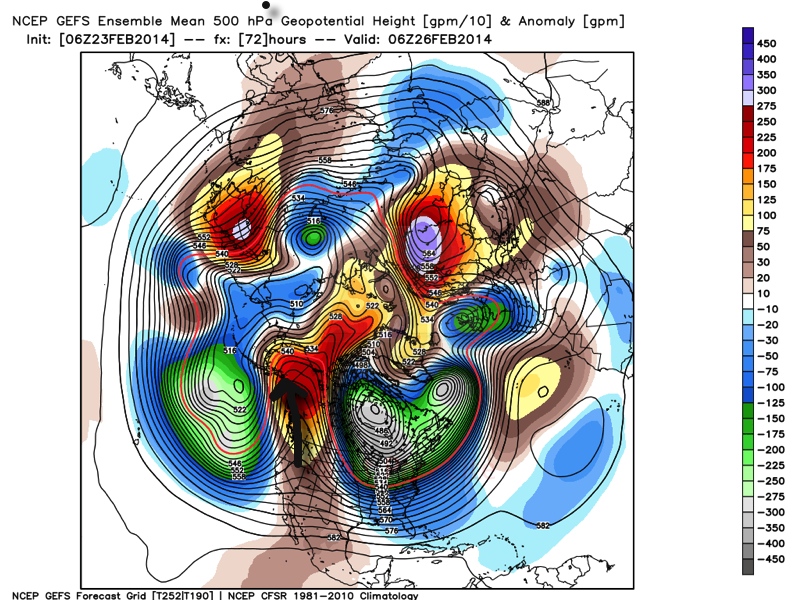
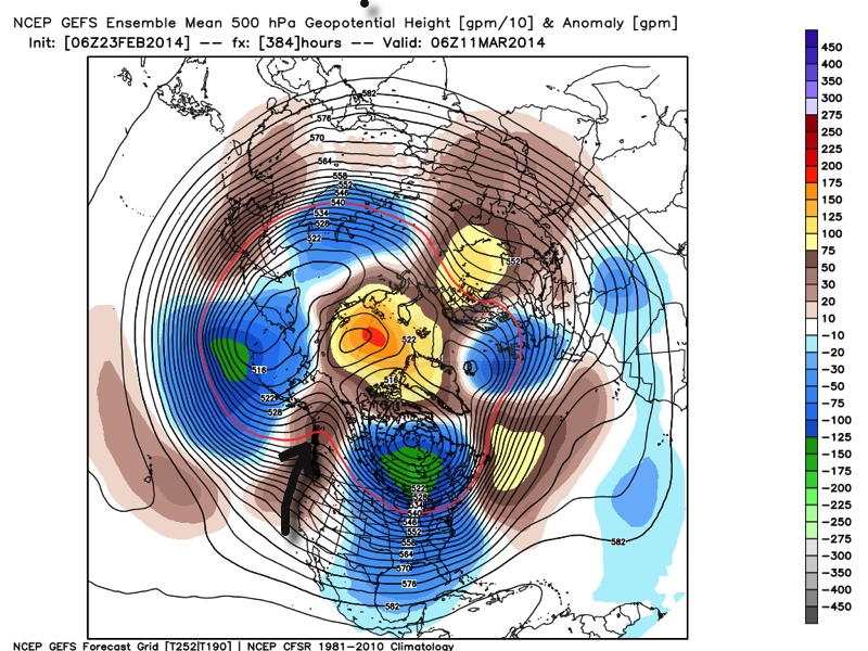
Ensemble data (below) shows ridging in the northeast Pacific, extending into Alaska and this pattern has been one of the big reasons as to why we’ve dealt with so many arctic intrusions this winter.  (The first image is a look at the upper air pattern dated Feb. 26th and the second is dated March 11th).

Ridging in this particular part of the globe often times dislodges the cold air and someone “down stream” has to deal with below normal air.  The recipient of being “down stream” has just so happened to be the upper Mid West into the Ohio Valley and much of the eastern half of the country this winter.  That doesn’t show any signs of changing over the next couple weeks, at least.  It’s possible we could deal with a day or two of milder weather thrown in the mix, but the overwhelming majority of the upcoming couple weeks looks much colder than normal.

GEFS1GEFS2

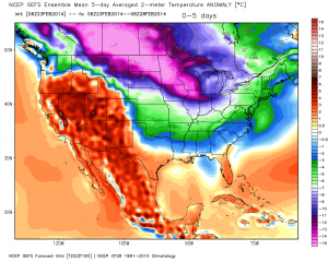
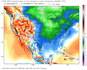
The result is a continuation of much below normal cold in our part of the country.  The following graphics illustrate temperature anomalies (in celsius) centered on 5 days between Feb. 23rd-28th and March 6th-11th.  Below normal temperatures continue.

GEFS3GEFS4


A couple of additional thoughts around the upcoming cold pattern: While we can’t show the images here (license issues), the “secret” European weeklies and ensemble data continues the cold, stormy regime across the east for the better part of the upcoming 30 days, with a couple of brief periods of milder, “calmer” weather.

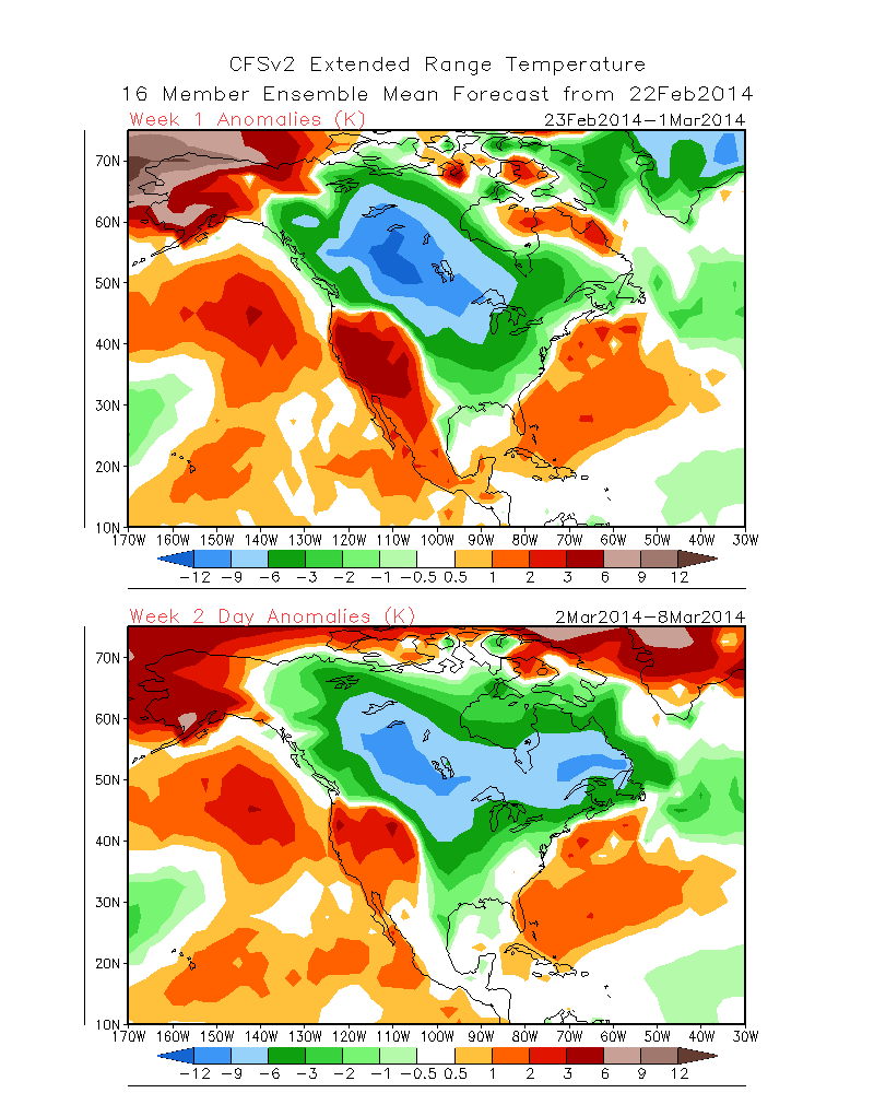
Finally, the CFSv2 suggests the cold regime continues, as well.  The first image shows upcoming weeks 1 and 2 and the second shows temperature anomalies weeks 3 and 4.  Note the CFSv2 shows southeast ridging developing towards the end of the period, potentially suggesting a big fight goes on between the cold to the north and the budding spring conditions to the south- a stormy suggestion…

CFSv2Wk1:2CFSv2Wk3:4

In closing, it’s important to note that all of the fancy graphics shown above are simply model guidance and it’s up to us, the forecasters, to interpret the data the best way possible to put together the most accurate mid to long range ideas for you, the viewer.  While nothing is a guarantee in this business, it does appear as if chances are quite high that our region deals with another few weeks of colder than normal conditions and potentially active weather ahead.  Stay tuned.

Permanent link to this article: https://indywx.com/2014/02/23/looking-ahead-cold-pattern-reloads/

Sunday Afternoon Thoughts…

1.) A scan over the latest data continues to point towards an absolute mess of a Monday afternoon.  Our accumulation ideas remain relatively unchanged from this morning’s update, aside from “beefing” expected snow totals for Indy’s northern ‘burbs by 1″.  Most of this falls from noon to 6pm and will be followed by a dry, cold, and blustery Monday night.  After likely a white-nuckle evening commute Monday, the combination of sub-freezing temperatures and gusty northwest winds Monday night will likely lead to another rough commute for Tuesday morning.

** We caution that this will be another “now cast” situation when it comes to precipitation types and their respected precise zones tomorrow afternoon.  Stay tuned here or to your favorite local weather media for updates and potential changes.**

  • Indianapolis northern ‘burbs, including Zionsville: 2-4″ snow and sleet with less than 0.10 of freezing rain.
  • Indianapolis proper: 2″ snow and sleet with around 0.10 of freezing rain
  • Indianapolis southern ‘burbs, including Greenwood: 1″ snow and sleet with up to 0.25 freezing rain.

Snow:IceForecast021714

2.) We continue to monitor what will be a brief thaw and associated flood risk mid week.  Even without rain, water rise would occur and urban flooding from the combination of melting snow and blocked (from all of the snow) drainage zones.  When you add 0.50-1″ of rain atop the melting then problems could arise Wednesday into Thursday.  Additionally, we’ll need to prepare for the likelihood of dense fog Wednesday as milder air surges north over a deep snow pack.

3.) For anyone thinking spring is setting in during our mid week thaw will need to think again. Latest model data continues to suggest we reverse things quickly later this week and for the upcoming weekend.  In fact, some model data, including the European, suggests central Indiana is under the gun for a weekend winter storm.  We’ll continue to monitor closely…

021614ECSatWinterStorm022214

4.)  Additionally, prospects continue to grow for another extended period of well below normal cold and renewed wintry precipitation chances in the long term (into March).  Both the GFS and European models are in agreement on the mid to long range pattern with a trough settling back into the eastern half of the country.

02161412zGFSEC

Permanent link to this article: https://indywx.com/2014/02/16/sunday-afternoon-thoughts/

Cold Today; Messy Monday Ahead.

Sun.

Mon.

Tue.

Wed.

Thr.

Fri.

Sat.

 Status-weather-clouds-icon

 Status-weather-freezing-rain-icon

 Status-weather-clouds-icon

 images

 Status-weather-storm-night-icon

 Status-weather-clouds-icon

 images

16/ 25

15/ 33

20/ 39

24/ 42

35/ 57

28/ 45

28/ 50 

0.00”

1-3″ (and ice)

0.00”

Trace

0.50″-1.00″

0.00″

0.00”

Forecast Updated 02.16.14 @ 11:15a

Cold Sunday…Fresh off celebrating our snowiest winter on record (surpassed last night at IND at 51.6″ and the Record Event Report can be found here), we’ll enjoy a dry day, but blowing and drifting snow will remain an issue in the open country. A few breaks in the cloud cover can be expected this afternoon on what will otherwise be a rather cloudy day.  Highs will only climb into the lower to middle 20s (well below the average high of 40 and closer to the normal low of 24).  Yes, our cold, snowy winter just keeps on keepin’ on!

Snow And Ice Issues Monday…A storm system will move through the region Monday and deliver a mixture of precipitation types across central Indiana.  The way we see things unfolding as of this forecast update brings a wintry mix of sleet and snow into the city around noon with periods of moderate to even heavy wintry precipitation falling into the mid to late afternoon hours before we begin to see the shield of moisture push northeast.  This will be a “thump and go” type event.

As for precipitation type, this remains a challenge and will require much fine tuning later tonight and through the day tomorrow (another now cast scenario).  We’re thinking mostly snow is the dominant form of precipitation from the northern suburbs of Indianapolis and points north.  Here, 2-3″ of wet snow is possible, polished off with a light glaze of a freezing rain/sleet mixture before precipitation ends.  For the city, itself, we think around 1-2″ of snow is possible with a glaze of freezing rain of around a tenth of an inch. Farther south, to include the southern Indianapolis suburbs, an icy mixture of sleet and freezing rain will be the concern with glaze potential approaching one quarter inch.  Again, we caution this is our best idea at this point and we’ll post some fresh thoughts later this evening.

Needless to say, tomorrow stands to include treacherous driving conditions in and around central Indiana and the National Weather Service will likely issue Winter Weather/ Freezing Rain Advisories later this afternoon to account for the wintry conditions anticipated tomorrow afternoon.

Flooding Concerns On The Rise…With such a deep snowpack across central Indiana, combined with a frozen ground, flooding concerns will be on the rise as early as the middle to latter part of the week.  We think dry and chilly (albeit milder) conditions will be with us Tuesday, but low clouds, fog, and drizzle likely develop by Wednesday as milder air streams north over the snowpack locked in across the region.

By Thursday, our attention turns to the potential of heavy rain and a couple of thunderstorms as a cold front blows through the region.  Early ideas of Thursday rainfall numbers would suggest anywhere from .50-1″ of rain is laid down and when combined with the heavy snow pack and milder air, flooding concerns will certainly be present.  Needless to say, if you live in a flood prone area, please monitor the situation closely later this week.

Winter Blows Back In…As promised, the briefly milder shot of air would be just that- brief.  We continue to monitor data that suggests a colder, more wintry, pattern blows right back into the region to wrap up February.

twic

For weather updates and more “behind the scenes” data on the go, be sure to Follow Us on Twitter @indywx or become a Friend of IndyWx.com on Facebook!

images

Permanent link to this article: https://indywx.com/2014/02/16/cold-today-messy-monday-ahead/

Snowy Friday On Tap (For Some)…

This will be quick this morning, due to time, but we’ll have your complete 7-Day forecast posted tonight. We’re continuing to monitor the weather situation Friday.  The Canadian has led…

You must be logged in to view this content. Click Here to become a member of IndyWX.com for full access.  Already a member of IndyWx.com All-Access?  Log-in here.

Permanent link to this article: https://indywx.com/2014/02/13/snowy-friday-on-tap-for-some/

Snowy Weekend Ahead Or Not?

With today’s latest forecast model runs in house, we have excellent run-to-run consistency, the only problem is, that run-to-run consistency amongst each model continues to disagree with one another. We…

You must be logged in to view this content. Click Here to become a member of IndyWX.com for full access.  Already a member of IndyWx.com All-Access?  Log-in here.

Permanent link to this article: https://indywx.com/2014/02/12/snowy-weekend-ahead-or-not/

Watching The Pattern Turn Active Yet Again…

After a dry period through early to mid week, our weather pattern will begin to turn active yet again as we head into late week and this weekend.  Three of our more trusted mid range computer models handle the individual impulses of energy differently and the snow potential ranges anywhere from nothing more than 1″ to as much as 10″ in the Friday-Tuesday period.  Most likely, we’re looking at something somewhere in the middle.

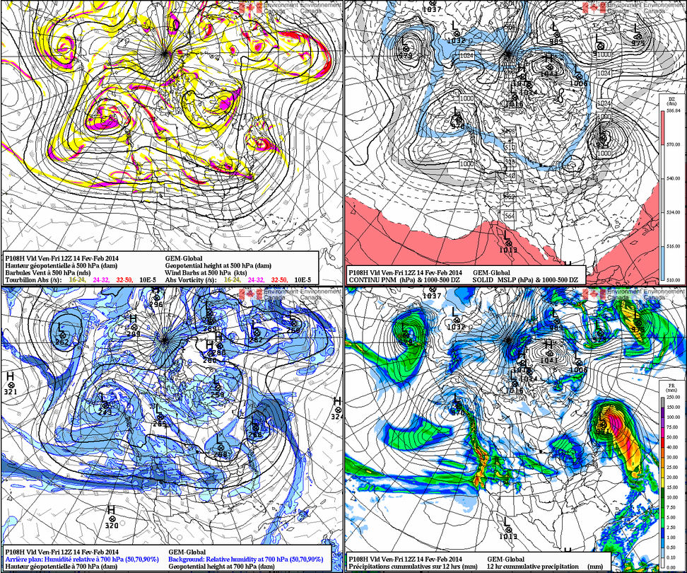
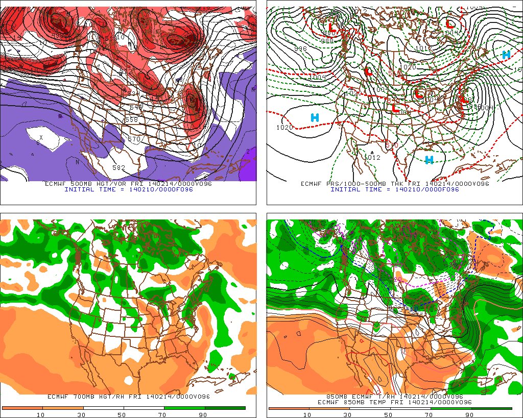
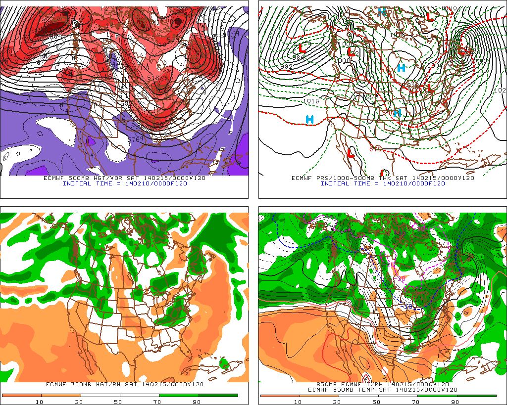
Our first chance of accumulating snow arrives Friday.  Both the European forecast model and Canadian forecast model agree on this, while the latest GFS takes the same energy through the Great Lakes, missing our region entirely.  We feel the GFS may be in error mode here.  While it’s possible the GFS may lead the way (anything is possible this far off), we feel the EC and Canadian have a better handle on things and we’ve based our forecast (post below) off a blend of these two models for Friday, including accumulating snow.

00_054_G1_north@america@zoomout_I_4PAN_CLASSIC@012_108f96

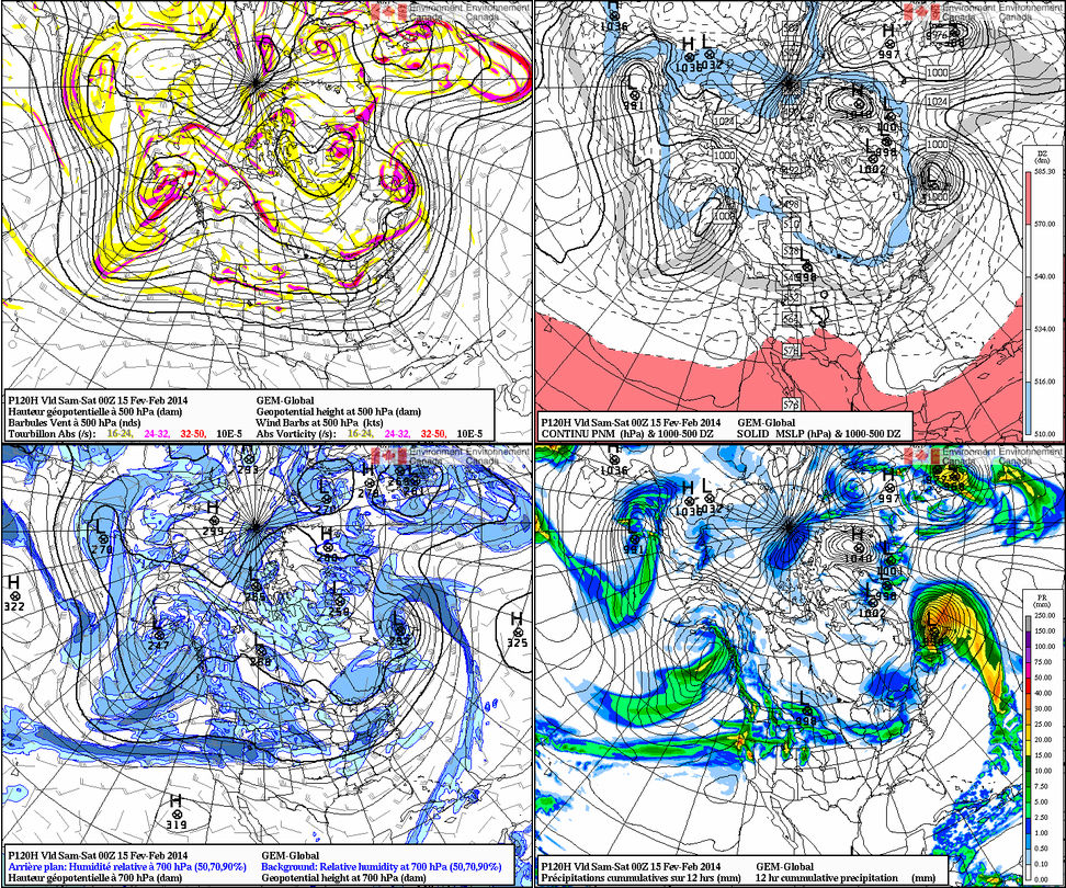
Our next shot of accumulating snow blows in Saturday.  All three models agree on this, but handle the track of the low, another clipper system, differently.  The Canadian tracks the low south of IND, strengthens it on it’s journey east and results in a full blown snow storm here Saturday.  The GFS and EC remain weaker and track the low across central or northern parts of the state, with much lighter snow amounts here.

00_054_G1_north@america@zoomout_I_4PAN_CLASSIC@012_120f120 gfs_namer_135_500_vort_ht_s

You can find your completed 7-Day forecast in the post below this one.  Finally, there are some signs the pattern may begin to relax and allow a milder brand of air into the region around the 20th.  We caution though that this won’t be a “suddenly it’s spring” pattern, but rather a tease of sorts as longer term signals suggest a wintry regime returns late February into March…

Permanent link to this article: https://indywx.com/2014/02/10/watching-the-pattern-turn-active-yet-again/

IndyWx.com