Thursday Morning Long Range Outlook…

Good morning!  We’ll have your full, updated, 7-day forecast posted here later this evening!  We wanted to discuss a few of the weather highlights as we move forward the next week, and beyond!

1.  A cold front will move through tonight and early Friday.  A shower or thunderstorm is possible as the front moves through, but won’t be a huge deal. Best rain/ storm chances appear to be across eastern portions of the region.

2.  Temperatures and humidity values will be at levels simply as pleasant as you can ask for this time of year Friday and Saturday.  Upper 60s to lower 70s during the afternoon and overnight lows in the upper 40s to lower 50s.  Hint of fall before true summer even begins?!  I’ll take it!

3.  Heat and humidity builds next week with ridging, but we continue to think this is a transient type pattern and seeds are already being planted for cooler times once past June 20th.  A couple days of 90 degree heat are possible mid to late next week.  Furthermore, with all of the moisture in the ground, humidity levels will be oppressive.  In other words, it turns hot and humid next week, but nothing too unusual for this time of year.  Like so many other times it’s tried to get hot this year, it seems as if the seeds for cooler are already being seen.

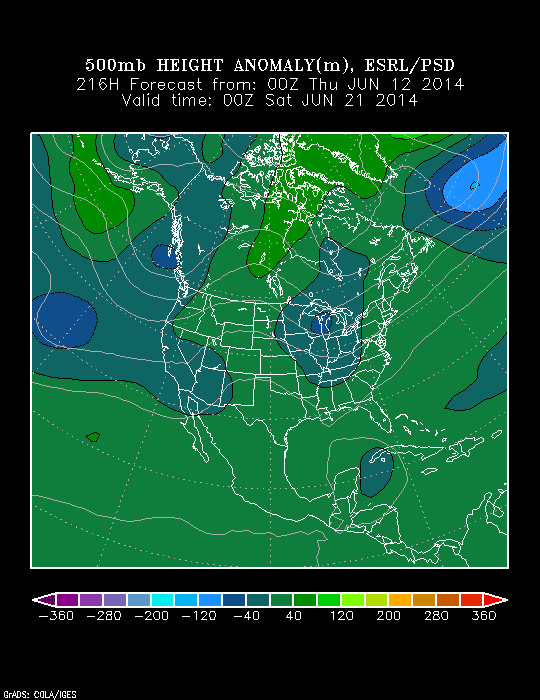
Lets examine some of the mid to long range model data.  We’ll start with a look at the 500 mb pattern off the GFS reforecast product from the Physical Science Division (PSD).  Note the riding that develops next week, but also note the trough and associated cooler pattern showing up just after the 20th.
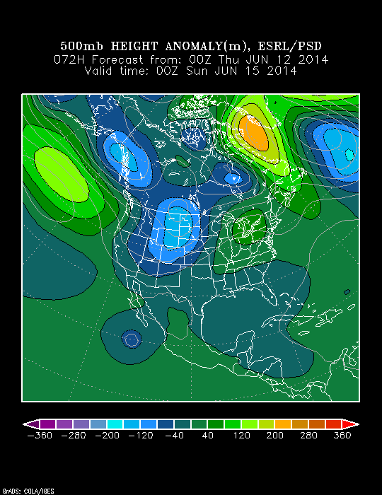
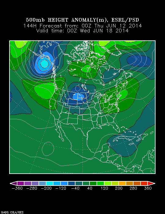
z500_anom_f072_ussmz500_anom_f144_ussmz500_anom_f216_ussm

The GFS ensembles show the warmth (they still aren’t representing the warmth to the magnitude in which we’re going to see in my opinion, but you get the overall idea) next week and the coming cooler pattern around, and after, the 20th, relative to normal.
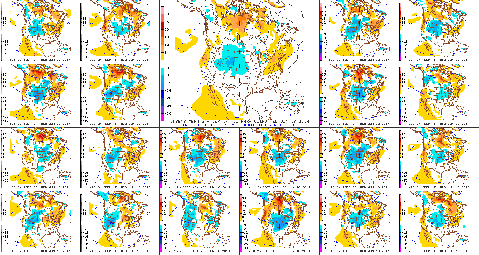
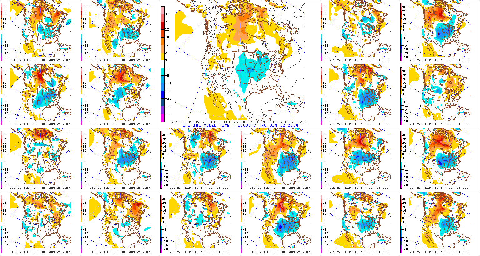
D6D9

The Canadian NAEFS product is next, outlining the temperature anomalies 6/20-6/27.  Note the warmer temperatures relative to normal (represented by the reds and orange hues) shifting off the east coast and the cooler temperatures (blue shades) developing and spreading east through the center of the country.
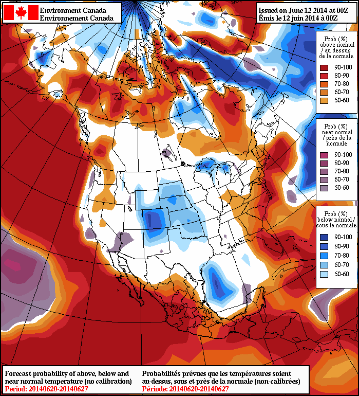
2014061200_054@007_E1_north@america_I_NAEFS@TEMPERATURE_anomaly@probability@combined@week2_198

Finally, let’s look at the CFSv2 weeks 3-4 product.  Again, we admit this model can be erratic at times, but we feel like it has a good handle on the coming pattern, as well, in this particular case.  The greens show the cooler than average pattern anticipated as we go through the back 7-10 days of June.

wk3.wk4_20140609.NAsfcT

As we close, it should also be noted that the overall active and wetter than normal pattern looks to continue as we put a wrap to the month of June.  We’re already off to a near-record pace for June rainfall across central Indiana and while we’ll have some dry days, the overall theme remains an active and wet one in the weeks ahead.

Much more with your full 7-day forecast later this evening!

Unsettled Wednesday…

Wed.

Thr.

Fri.

Sat.

Sun.

Mon.

Tue.

 Status-weather-showers-day-icon

 Status-weather-showers-day-icon

 Status-weather-clouds-icon

 Status-weather-clouds-icon

 Status-weather-clouds-icon

 Status-weather-showers-day-icon

 Status-weather-showers-day-icon

64/ 74

60/ 79

60/ 73

51/ 75

59/ 83

70/ 84

71/ 88 

Light

Light

– – –

– – –

– – –

Moderate

Moderate

The big ole’ area of low pressure that we’ve been talking about now for a few days will continue to influence our weather today.  It certainly won’t rain the entire time and we may even see some sunshine at times today. That said, locally heavy down pours in scattered rain bands can be expected yet again.  Drier air will slowly move in Thursday, but a cold front will blow through the area Thursday night into Friday morning and a thunderstorm is possible as this front blows across the region.  A much drier, cooler air mass will move in behind this boundary and set up a pleasant time of things Friday and Saturday.  As we move into another new week temperatures will warm dramatically and the hottest weather of the season will be accompanied by unsettled weather Monday and Tuesday.

Tuesday Evening Video Update!

Good evening and thank you for logging onto IndyWx.com!  Tonight’s video covers the unsettled time of things tonight into Wednesday morning as low pressure continues to have a hold on our area’s weather.  Also, we talk long range weather and give you an idea of what you can expect for the rest of the month of June, temperature-wise!  While we didn’t get into the precipitation side of things in tonight’s video for late month, I will say it continues to look very unsettled with above average rainfall anticipated to wrap up the month of June.  Anywhere from an additional 3-5″ of rain is possible as we go through the rest of the month here across central Indiana.

While the CFSv2 can be a bit erratic at times, we feel the model has a good handle on the way the overall pattern will evolve late June into July.

Soaking Rain Tuesday…

Tue.

Wed.

Thr.

Fri.

Sat.

Sun.

Mon.

 Status-weather-storm-night-icon

 Status-weather-storm-night-icon

 Status-weather-showers-day-icon

 Status-weather-showers-day-icon

 Status-weather-clouds-icon

 Status-weather-clouds-icon

 Status-weather-showers-day-icon

62/ 71

64/ 76

58/ 78

63/ 73

52/ 75

56/ 86

66/ 87 

Moderate

Light

Light

Light

– – –

– – –

Light

A slow moving, swirling, area of low pressure will impact the central Indiana region over the course of the next couple days.  This spells a more humid time of things with a deep southerly flow in place, but with all of the clouds around, expect temperatures to average below normal Tuesday and Wednesday.  We’re looking at steady rains pushing northeast early Tuesday morning and sticking around for the better part of the day, including periodically heavy down pours.  Rain will begin to scatter in coverage Wednesday, but the better part of the day will be wet, with continued embedded heavy rain.  We continue to think widespread rainfall totals of 1-2″ is a good bet over the course of the upcoming 48 hours.  Drier air will slowly begin to invade Thursday, but we can’t completely shake the shower chance.  Finally, as we get set to close out the work week, a cold front will move through the area. A shower or thunderstorm is possible Friday as the front slides through, but the bigger deal will be the punch of drier, cooler air behind the boundary. This will set the stage for yet another ideal Saturday, weather-wise!  Warmth and humidity will build late in the weekend and continue into the first part of next week.

Soaking Rain Ahead Tuesday Into Wednesday.

We still think most of today is dry and while we’re off to a cloudy start, the latest scan of the visible satellite image would suggest some brightening of the sky is a good bet from time to time late morning into the afternoon.

20140609_1145_sm_EVV_vis

Enjoy whatever sunshine you see today, as clouds begin to lower and thicken this evening and widespread rain won’t be far behind.  The simulated radar shows rain and embedded thunder will be rather widespread Tuesday.

6am Tuesday future radar product
11a Tuesday future radar product
2a Wednesday future radar product

Widespread rainfall totals of 1-2″ will be a good bet between Tuesday and Wednesday and we feel the short-term, high resolution, NAM forecast model has a good handle on the distribution of precipitation.  There will be locally heavier totals.

hires_t_precip_ky_20

We’ll have your complete 7-day forecast updated and posted later this evening!