
You must be logged in to view this content. Click Here to become a member of IndyWX.com for full access. Already a member of IndyWx.com All-Access? Log-in here.
Category: Forecast Discussion
Permanent link to this article: https://indywx.com/video-frigid-times-moderate-looking-ahead/
Jan 17
Frigid Air Relaxes; What Awaits?
2018 has opened on an absolutely frigid note. Indianapolis is running an amazing 11° below average through mid-month.
 Eight mornings so far this winter have plunged below zero. We’ll see if we can add another to that list this morning (IND is officially at 0° as we write this).
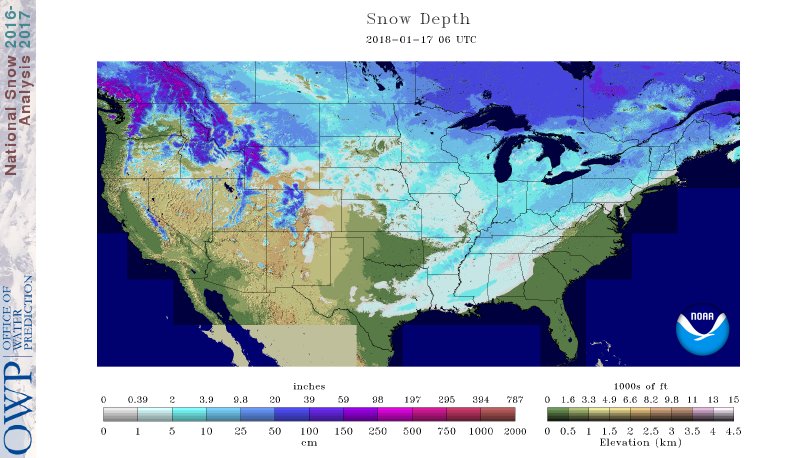
52% of the country is covered in snow. In fact, my old stomping grounds of Auburn, AL received 3″ of the white stuff overnight!
 If you’re sick and tired of the cold, wintry conditions relief is on the way. We’ll turn “less cold” through late-week and above normal over the weekend (around 40° Saturday and into the upper 40s Sunday).
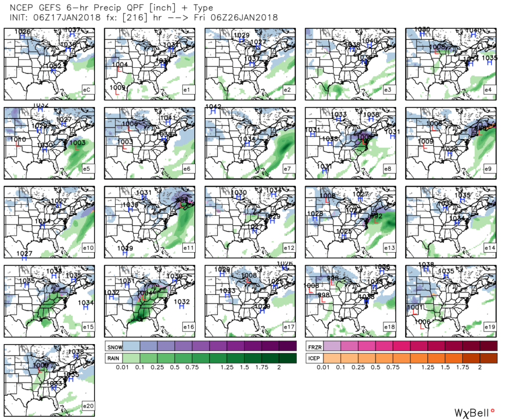
 A storm system will cut into the ridge Sunday with showers (image 1) followed by “backlash” snow showers and gusty winds Monday (image 2).

 Thereafter, models see another storm that will approach the region late next week. Since cold air won’t be readily available, it’ll take the perfect track to get impactful wintry conditions from this next event. We’ll monitor things closely next week. With this near Day 10, models will continue to struggle with timing, track, and intensity over the next few days.
 As a whole, the second half of January should run milder than average. However, as we all know, that doesn’t mean we won’t have wintry challenges to deal with. The upcoming (10) days illustrates that nicely. Looking ahead, we note the MJO is forecast to rumble through the warmer phases (especially if you’re reading this from the eastern regions of the country- where we expect warmth to be most anomalous into early February).

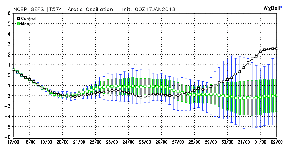
 Other teleconnections also support a relaxation of the cold, and warmer times, overall, with the exception of the Arctic Oscillation which remains negative through the period.
 It should be noted that the longer range data and overall trends, supported by our analogs, suggest winter roars back with authority as we get into February. In fact, winter might not be so quick to leave this year either. Data paints a cold, wintry open to meteorological spring this year, but we’re getting way ahead of ourselves. It is only mid-January, after all. 🙂
Permanent link to this article: https://indywx.com/frigid-air-relaxes-what-awaits/
Jan 14
VIDEO: Moderate To Heavy Snow Moves In Monday Morning…
You must be logged in to view this content. Click Here to become a member of IndyWX.com for full access. Already a member of IndyWx.com All-Access? Log-in here.
Permanent link to this article: https://indywx.com/video-moderate-to-heavy-snow-moves-in-monday-morning/
Jan 13
Another “Plowable” Snow Gives Way To Sub-Zero Cold…
With the exception of light lake effect snow showers today (noticing a couple of light bands just west of the city as we write this Saturday morning around 10a), most of today and Sunday will be dry and cold. We’ll top out around 20° today and Sunday with low temperatures tonight dropping into the 0° to 5° range.
Our next snow maker will arrive late Sunday night into Monday morning in the form of a clipper system.
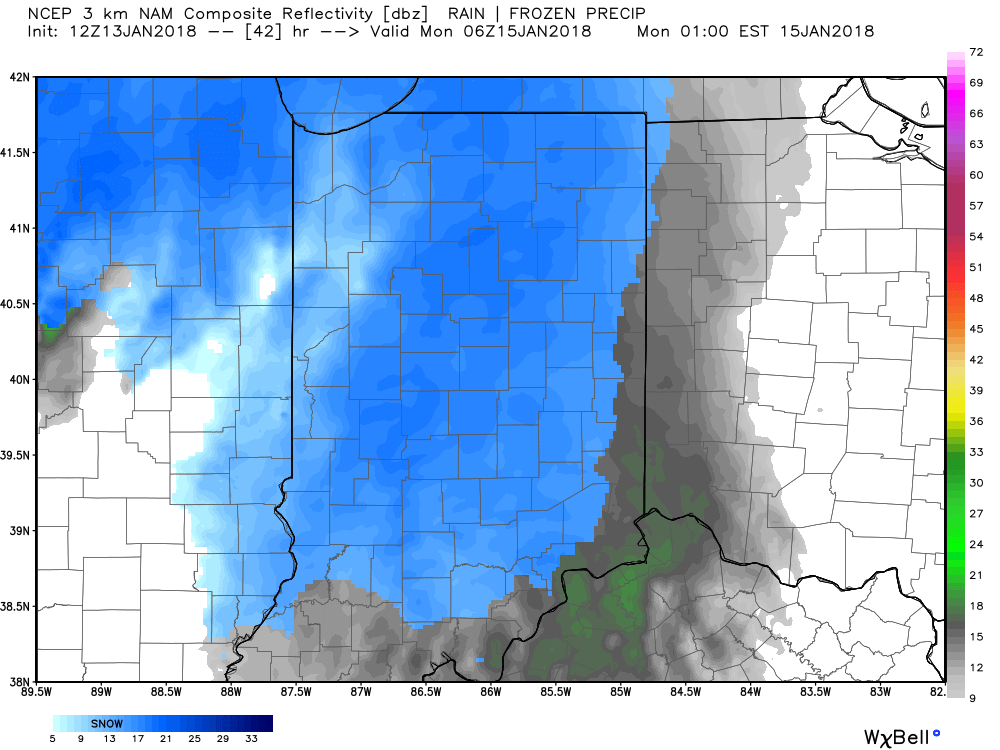
Forecast radar 1a Monday.
We expect light snow Monday morning to grow in overall coverage and intensity through the late morning and into the early afternoon hours.
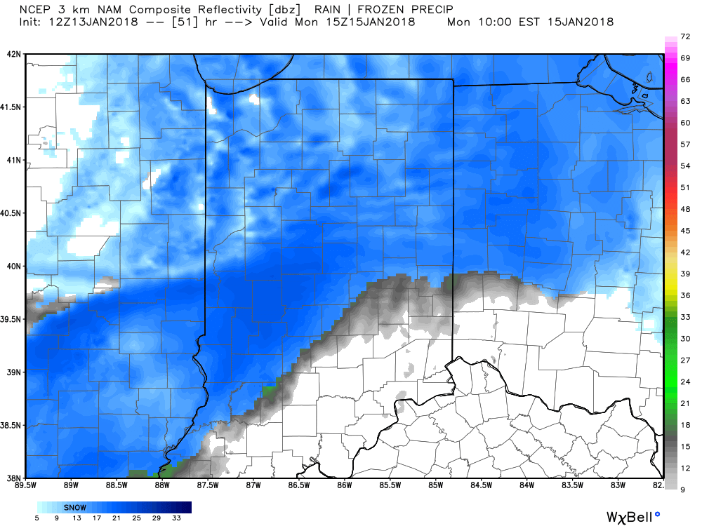
Forecast radar 10a Monday.
Accumulating snow will push off to the south Monday evening.

Forecast radar 7p Monday.
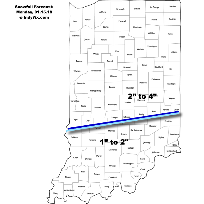
This will be a plowable event for central Indiana and we’ll also have to deal with blowing and drifting concerns Monday afternoon through Monday night as strong and gusty northwest winds arrive. Needless to say, to our snow removal and DPW crews out there, find a way to get some rest this afternoon and Sunday before another busy stretch to open the work week. We think additional snowfall of 2″ to 4″ is a good bet across the northern half of the state, with slightly lighter amounts of 1″ to 2″ across southern Indiana.
 Arctic high pressure will settle over a growing snowpack to help setup a frigid stretch through early and mid week. Multiple nights with below zero readings are expected beginning Tuesday morning where most will wake up to readings of 3° to 8° below zero (not counting the wind chill).

Permanent link to this article: https://indywx.com/another-plowable-snow-gives-way-to-sub-zero-cold/
Jan 11
VIDEO: Two Winter Events Impact Central Indiana Between Friday And Monday…
You must be logged in to view this content. Click Here to become a member of IndyWX.com for full access. Already a member of IndyWx.com All-Access? Log-in here.
Permanent link to this article: https://indywx.com/video-two-winter-events-impact-central-indiana-between-friday-and-monday/