
You must be logged in to view this content. Click Here to become a member of IndyWX.com for full access. Already a member of IndyWx.com All-Access? Log-in here.
Category: Forecast Discussion
Permanent link to this article: https://indywx.com/video-ready-for-wintry-fun-and-games/
Dec 12
Latest Thoughts On Early Next Week; Long Range Update Into Early Jan…
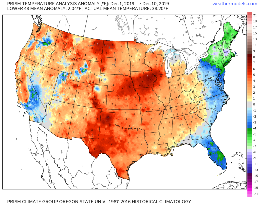
Through the 11th, December is running 1.6° above normal in Indianapolis. This milder than normal theme is rather widespread so far this month through the Lower 48.
As we look ahead, there are continued reasons to believe the pattern will begin to go through more of a transition towards an ultimately more sustained cold pattern as January evolves. We think that transition really started early this week and will feature plenty of “back and forth” over the the next 2-3 weeks before settling into the more sustained cold regime. There will be storms and “rumors of storms” that we’ll have to track through the transitional period, including smack-dab in the heart of the holiday season this year.
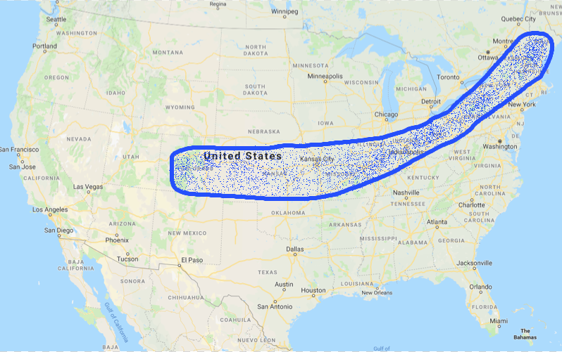
The latest JMA Weeklies (update each Thursday morning) shows this “fight” over the next 1-3 weeks.

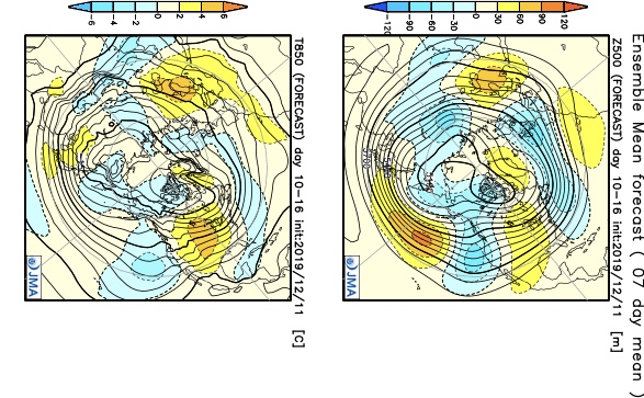
Without blocking in place, the way the JMA Weeklies handle the pattern is likely, but the Weeks 2-3 time period does have a chance to offer up a headache or two as the models may begin to adjust to an increasingly “blocky” time of things.
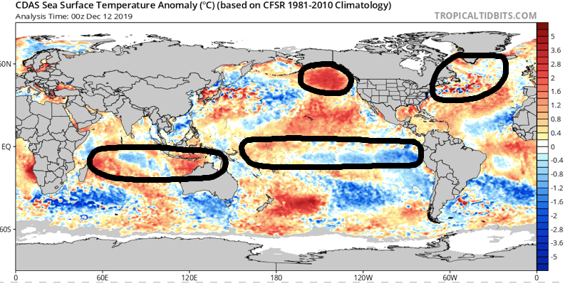
There are at least “hints” that some of the teleconnections that would promote more of a blocky pattern are beginning to align. We caution though that this does take time for these feature to mature and begin to ultimately have a greater impact on our pattern.

As we revisit the latest SST configuration, there’s continued reason to be very excited about this winter if you’re a fan of colder and snowier than normal conditions. We always knew December would be the tough month before the pattern settles into the mean winter pattern late December into March. Now, time to just sit back and watch things unfold. 🙂
Now, back to the short-term. Despite forecast models very much still in (2) separate worlds, we’ve dug into analogs and looked through countless similar patterns from the past. As model consensus develops (hopefully sooner rather than later), let’s see if they (speaking specifically to the GFS and European) converge on this similar solution for best chances of accumulating snow:
We still have many details to sort through and we caution that this system is far from being etched in stone. You’ll want to keep close tabs on latest developments over the next couple of days. With that said, we’re looking for potential wintry impacts here across central Indiana beginning Sunday night and continuing through Monday.
This evening’s video update will focus solely on the Sunday-Monday system, including the latest model developments from 12z. Have a great Thursday!
Permanent link to this article: https://indywx.com/latest-thoughts-on-early-next-week-long-range-update-into-early-jan/
Dec 11
Several Opportunities For Wintry Weather Over The Next Couple Of Weeks, But Many Details To Sort Through…
You must be logged in to view this content. Click Here to become a member of IndyWX.com for full access. Already a member of IndyWx.com All-Access? Log-in here.
Permanent link to this article: https://indywx.com/several-opportunities-for-wintry-weather-over-the-next-couple-of-weeks-but-many-details-to-sort-through/
Dec 10
Light Snow Chances Wednesday; Something More Exciting Late Weekend?
You must be logged in to view this content. Click Here to become a member of IndyWX.com for full access. Already a member of IndyWx.com All-Access? Log-in here.
Permanent link to this article: https://indywx.com/light-snow-chances-wednesday-something-more-exciting-late-weekend/
Dec 09
Something More Meaningful Lurking Around the Corner (From a Wintry Perspective)?
Our December thoughts remain unchanged, and the increasingly active 2nd half of the month will provide challenges. This is in the face of what should still be a relatively mild pattern- or only marginally cold for the most part. This is likely the beginning of the transition towards more sustained cold, wintry times as 2020 gets underway, but there will be a big fight in the midst of the transition.
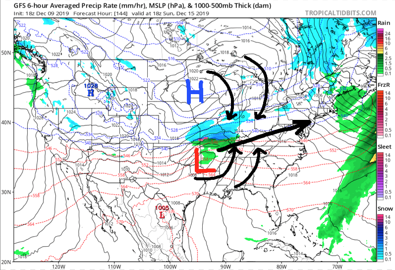
The first challenge awaits late in the weekend and early next week and today’s model data is in more agreement with the handling of a set of features that may produce a stripe of accumulating snow from the central Plains into the Ohio Valley during the aforementioned time period.
The set-up is one that should feature a surface wave develop in the central Plains (likely TX/ OK panhandle) Saturday afternoon. From there the wave of low pressure will scoot across Arkansas and into the lower Ohio Valley. There are some intriguing details present with this system that have been missing from other systems we’ve seen from late fall into the early portions of meteorological winter: 1.) Timing of the system with at least marginally cold air drilling in behind departing EC system. 2.) Position of the surface high funneling cold air into the system (as opposed to departing as the system arrives). 3.) Overall modeled favorable track.
Now, there are obviously some questions remaining that will have to be answered in the days ahead (always the case when a feature is 6-7 days away), but it’s most certainly something to keep close tabs on as we move forward. As things stand now, I’d monitor the Sunday-Monday time frame for possible wintry impacts across central Indiana.
This has our attention and subsequent updates will follow as we move forward.
Permanent link to this article: https://indywx.com/something-more-meaningful-lurking-around-the-corner-from-a-wintry-perspective/