Updated 02.06.22 @ 9:37a
You must be logged in to view this content. Click Here to become a member of IndyWX.com for full access. Already a member of IndyWx.com All-Access? Log-in here.

Feb 06
Updated 02.06.22 @ 9:37a
You must be logged in to view this content. Click Here to become a member of IndyWX.com for full access. Already a member of IndyWx.com All-Access? Log-in here.
Permanent link to this article: https://indywx.com/video-chilly-pattern-persists-with-fast-moving-clipper-systems-in-the-days-ahead/
Feb 05
Updated 02.05.22 @ 8a
You must be logged in to view this content. Click Here to become a member of IndyWX.com for full access. Already a member of IndyWx.com All-Access? Log-in here.
Permanent link to this article: https://indywx.com/video-short-term-update-and-long-range-pattern-discussion-to-close-out-february/
Feb 04
Updated 02.04.22 @ 7:30a
You must be logged in to view this content. Click Here to become a member of IndyWX.com for full access. Already a member of IndyWx.com All-Access? Log-in here.
Permanent link to this article: https://indywx.com/video-the-snowy-beat-goes-on-tracking-clipper-systems-in-an-almost-every-other-day-fashion/
Feb 03
Updated 02.03.22 @ 7:05a
You must be logged in to view this content. Click Here to become a member of IndyWX.com for full access. Already a member of IndyWx.com All-Access? Log-in here.
Permanent link to this article: https://indywx.com/video-let-it-snow-let-it-snow-let-it-snow/
Feb 02
Updated 02.02.22 @ 8:47p
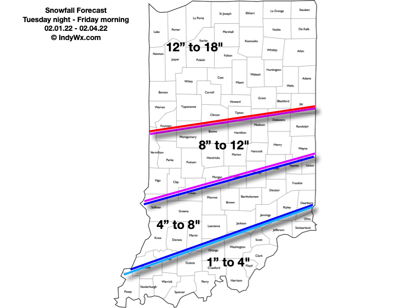
After reviewing the latest data, we have no reason to adjust our ongoing ideas from our latest Client Brief or this morning’s video discussion. Thursday will feature a prolonged period of heavy snow into the evening hours, along with an increasingly stiff NNE wind that will lead to significant blowing and drifting issues- especially during the afternoon and evening. Much more in the AM, friends!
Permanent link to this article: https://indywx.com/video-its-show-time/