Updated 02.19.22 @ 7:45a
You must be logged in to view this content. Click Here to become a member of IndyWX.com for full access. Already a member of IndyWx.com All-Access? Log-in here.

Feb 19
Updated 02.19.22 @ 7:45a
You must be logged in to view this content. Click Here to become a member of IndyWX.com for full access. Already a member of IndyWx.com All-Access? Log-in here.
Permanent link to this article: https://indywx.com/video-tracking-2-systems-next-week/
Feb 18
Updated 02.18.22 @ 7:35a
You must be logged in to view this content. Click Here to become a member of IndyWX.com for full access. Already a member of IndyWx.com All-Access? Log-in here.
Permanent link to this article: https://indywx.com/video-spring-fling-followed-by-opportunity-of-another-impactful-storm-system/
Feb 17
Updated 02.17.22 @ 7:35a
You must be logged in to view this content. Click Here to become a member of IndyWX.com for full access. Already a member of IndyWx.com All-Access? Log-in here.
Permanent link to this article: https://indywx.com/video-spring-fling-early-next-week-but-a-lot-of-winter-is-left-in-the-tank/
Feb 16
Updated 02.16.22 @ 8p
Type: Impactful Wintry Weather, Flooding, and Severe Storms

What: Impactful wintry weather; Localized flood threat; Severe storm potential downstate
When: Thursday
Temperatures: Lower 50s midnight Thursday crashing into the lower 20s by midnight Friday morning.
Wind: Variable 15-30 MPH
Blowing/ Drifting: Minimal (due to heavy, wet nature of the snow) across northern Indiana; non-existent elsewhere
Pavement Impacts: Plowing and salting will be required
Summary: A strengthening area of low pressure will move across the state Thursday afternoon, dragging a cold front southeast. Heavy rain will be widespread across the state Thursday morning. As cold air presses southeast, the 1st round of precipitation will transition to a wintry mix of sleet and freezing rain across far northern Indiana (along and north of a line from Rensselaer up to South Bend) mid to late morning. A secondary area of precipitation will then be blossoming off to our southwest and push northeast into the state through the afternoon. Central Indiana and points south will continue to deal with rain, along with falling temperatures, while downstate (Bloomington over to Greensburg and points south) gears up for the potential of severe t-storms in the 3p to 6p window. Any severe storms that do develop will be capable of producing damaging straight line winds.


Meanwhile, cold air will continue to settle southeast and lead to a transition from heavy rain to a wintry mix of sleet and freezing rain for northern Indy ‘burbs towards 3 or 4p, eventually making it into the city, itself, in time for the evening rush.
Before the transition to a wintry mix, widespread 1”-2” of rain with locally heavier amounts can be expected across central Indiana, including Indianapolis. Further north, heavy snow can be expected, including widespread 4”-8” amounts with locally heavier totals. I think the latest high resolution NAM is handling snowfall numbers quite well this evening and don’t see any reason to disagree with these numbers.
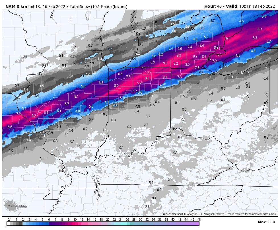
A dusting to coating of snow (less than half an inch) is possible into the city as the sleet and freezing rain mixture transitions to the white stuff prior to precipitation exiting the region Thursday night. As temperatures crash, a “flash freeze” is possible even into southern Indiana by Friday morning.
Confidence: High
Next Update: 7:30a Thursday
Permanent link to this article: https://indywx.com/client-brief-significant-and-multifaceted-storm-impacts-region-thursday/
Feb 16
Updated 02.16.22 @ 7:21a
You must be logged in to view this content. Click Here to become a member of IndyWX.com for full access. Already a member of IndyWx.com All-Access? Log-in here.
Permanent link to this article: https://indywx.com/video-significant-storm-delivers-a-wide-range-of-impacts-mjo-influence-on-the-longer-range/