As another wintry event comes to an end, most Hoosiers are ready for spring. As we look ahead at the upcoming couple of weeks, there are signs that at least a “taste” of spring awaits. But, as is typically the case, there are contradicting signals.
The consensus from our big player teleconnections would suggest a warm-up (compared to normal) in the 5-10 day period, but note that the trends are favorable for cooler than normal temperatures thereafter.
Ensemble guidance shows the transition over the upcoming couple weeks.
The Madden Julian Oscillation (MJO) argues that eastern warmth should come back with a vengeance towards mid-March after the potential of a brief cooler setback. We note guidance is in better alignment taking things into Phase 5 and that should result in an expanding eastern ridge between the 10th and 15th.
The JMA Week 2 500mb pattern looks pretty good to me based on the MJO activity. Meanwhile, unseasonably cold air is likely to dump into the West and we’ll have ti monitor thing the pattern drivers closely once passed mid-month for the possibility of colder air to ooze east.
The transitional theme to the overall pattern should promote wetter than normal conditions over the upcoming 14-16 days as a whole.
A light mixture of snow and freezing rain will overspread the region during the evening, continuing into the overnight hours.
What: Impactful wintry weather
When: Tonight and Thursday morning and Thursday afternoon through predawn Friday
Temperatures: Middle 20s to lower 30s
Wind: East Northeast 10-20 MPH, shifting to the north late Thursday
Blowing/ Drifting: Minimal across n-central Indiana
Pavement Impacts: Plowing and salting will be required across n-central Indiana and points north. Salting required across southern and central Indiana.
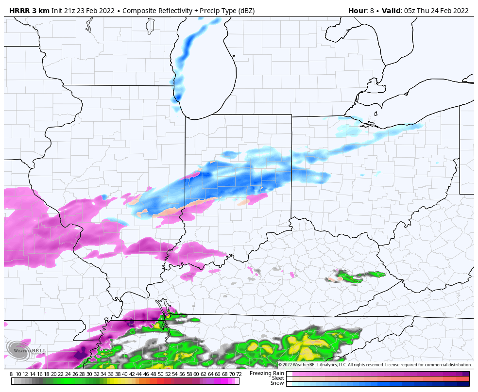
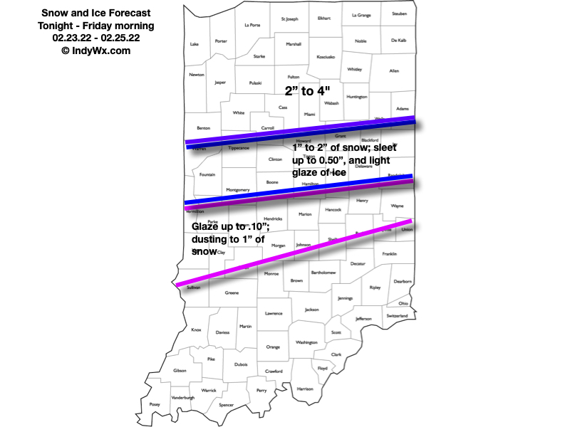
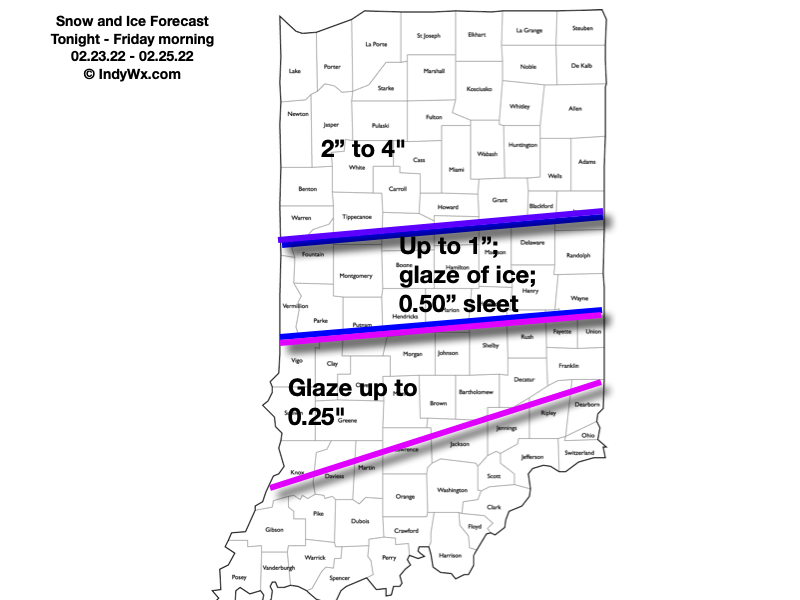
Summary: (2) waves of moisture will stream over central Indiana between this evening and predawn Friday. The initial, lead wave of precipitation will feature a mixture of light snow, light sleet, and light freezing rain. “Light” is the key word, but area roadways will likely become slick through the evening and into tonight- including in and around Indianapolis-proper. In and around the I-70 corridor and points north, this precipitation is expected to primarily fall in the form of snow. Further south, a mixture of sleet and freezing rain is anticipated. While this will be light in nature, precipitation should be rather persistent, lasting up until, or just after, sunrise. By sunrise, areas in and around Indy and points north can expect between 0.50″ and 1.50″ of snow (should sleet mix in, amounts will be closer to the lighter end of the spectrum vs. if we stay mostly snow, amounts closer to 1.5″ can be expected). Further south, a light glaze (up to 0.1″) and light sleet is expected to be the predominant precipitation type with this initial wave of moisture.
We’ll then undergo a “lull” in the action mid morning into the early afternoon hours, but low pressure will be organizing off to our southwest and have eyes set on a northeast trek into the southern portion of the state Thursday evening. This will be when we anticipate the heavier precipitation to move across the region. Across southern IN, this should primarily fall in the form of a cold rain, but further north the same can’t be said: a wintry mix of sleet and freezing rain is expected to redevelop Thursday afternoon and continue into the night before ending as light snow. Across n-central IN and points to the MI/ IL state line, all snow is anticipated.
Precipitation will diminish from southwest to northeast predawn Friday with high pressure regaining control of our weather to close out the work week (just a few light lingering snow showers are expected Friday). Please see our updated snow and ice forecast below that includes total amounts for both parts of this event.
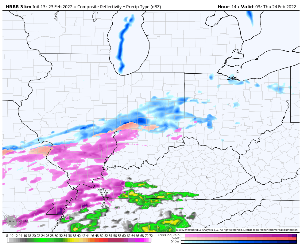
As we analyze downstream radar trends and fresh high resolution, short-term guidance, it appears as if the initial burst of precipitation is speeding up. It now looks like a mixture of light snow and light sleet will arrive into central Indiana between 7p and 10p.
Forecast radar at 10p Wednesday.
Along and north of the I-70 corridor, this should fall primarily as snow (up to 1”). Further south, a mixture of sleet and freezing rain is expected this evening (where things remains all freezing rain, a light glaze, perhaps up to 0.1”. is expected to develop on elevated surfaces by sunrise).
Our updated client brief will be posted later this evening and include additional thoughts as the 12z data streams in.