Category: Forecast Discussion

Couple Dry Days Ahead Of Friday Storms; Weekend Cool Down…

Wed.

Thr.

Fri.

Sat.

Sun.

Mon.

Tue.

 Status-weather-clouds-icon

 Status-weather-clouds-icon

 Status-weather-showers-day-icon

 Status-weather-showers-day-icon

 Status-weather-clouds-icon

 Status-weather-clouds-icon

 Status-weather-showers-day-icon

63/ 84

62/ 87

67/ 89

58/ 73

51/ 74

51/ 75

56/ 79 

Dry Time…Sun-filled days can be expected after morning fog burns off across outlying areas both today and Thursday.  Temperatures will be a touch above normal.

Friday Night Storms Ahead Of Big Cool Down…A cold front will pass the state early Saturday.  Ahead of this front, a line of strong to severe storms will be possible Friday night.  We’ll fine tune timing as we progress through the next day or two.  A blast of much cooler, drier air will then pour into the state over the weekend.  It’ll feel very much like fall around these parts…

Next Rain Maker…We’ll enjoy another dry and seasonably cool couple days before our next potentially significant rain maker gears up for the middle of next week.  Both the GFS and European forecast models are hinting this could be a significant rain maker, but caution this is still early and fine tuning will be required.

7-Day Precipitation Forecast:

  • 7-Day Rainfall Forecast: 0.50″ – 1.00″
  • 7-Day Snowfall Forecast: 0.00″

Farmer Paul of Full Circle Farm sent in this beautiful fog bank shot this morning.  Full Circle Farm is located across southern Boone County in Whitestown.  We encourage you to check out their web site if you haven’t already.  Thanks, Paul!

BwmoKzlIEAAPEAN


Permanent link to this article: https://indywx.com/2014/09/03/couple-dry-days-ahead-of-friday-storms-weekend-cool-down/

Wet Pattern Looks To Continue Into Mid Month…

I was out and about earlier today and taking note that local lawns are much greener than they typically have been over the past few years by early September.  We can thank recent rains and warmth, but it’s been a wet year, overall, to date.  Think back to all of the winter snows and then add the copious spring and summer rains.  The end result so far?  2014 is running close to 2″ above normal precipitation at IND.

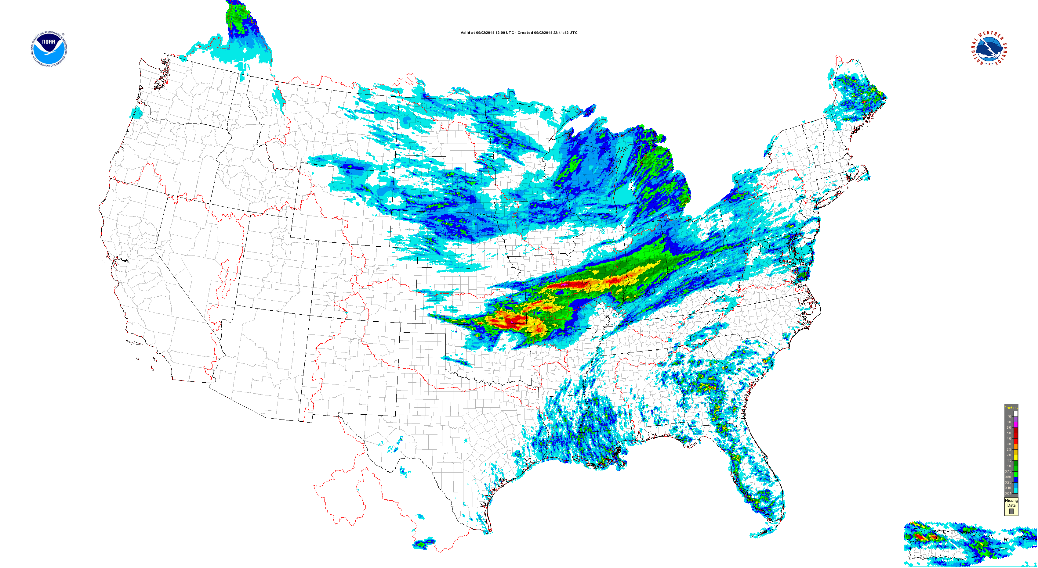
Overnight rains went close to forecast.  We picked up 1″ on the dot in the city, including northern ‘burbs.  (IndyWx.com HQ in southern Boone County also picked up 1″).  Heavier rains and localized flash flooding took place down state.

A look at today’s rainfall:

conus_precip-composite_hi_res

Moving forward, the pattern over the upcoming (2) weeks appears wetter than normal.

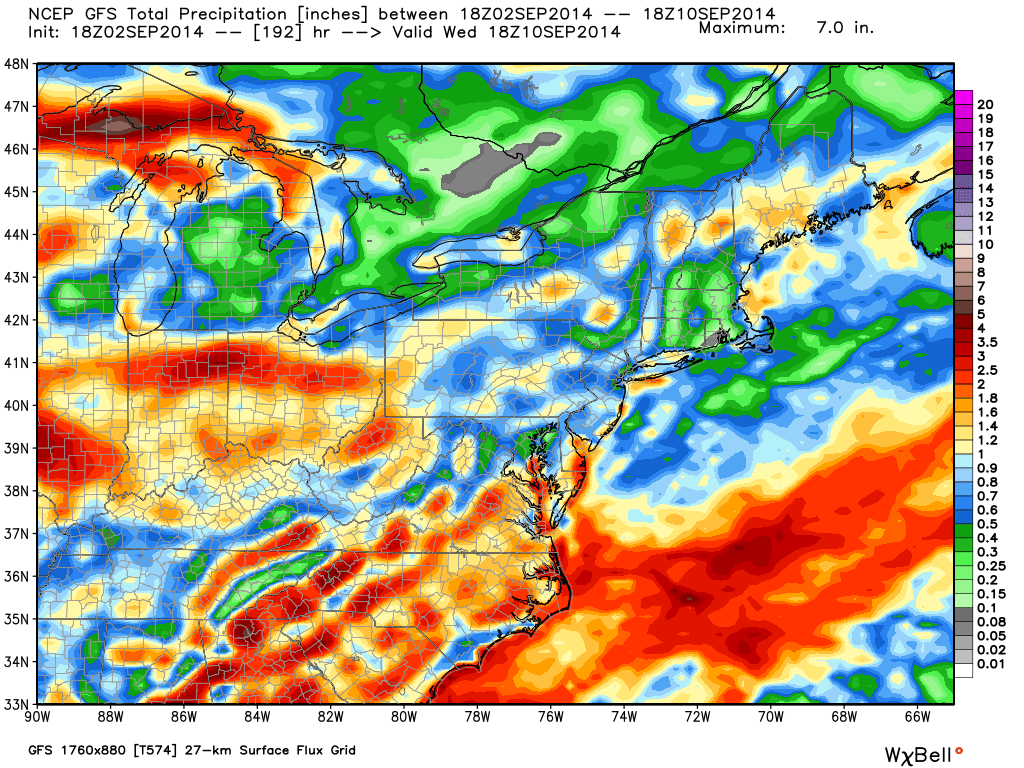
In the shorter term, the GFS and Canadian paint a wet picture out by Days 7-10 (BTW- the European agrees).

gfs_tprecip_ma_65


cmc_total_precip_ma_41

Modeling suggests 2-3″ type rainfall is possible over the upcoming 7-10 day period.  A transient pattern can be thanked for the overall wet forecast.

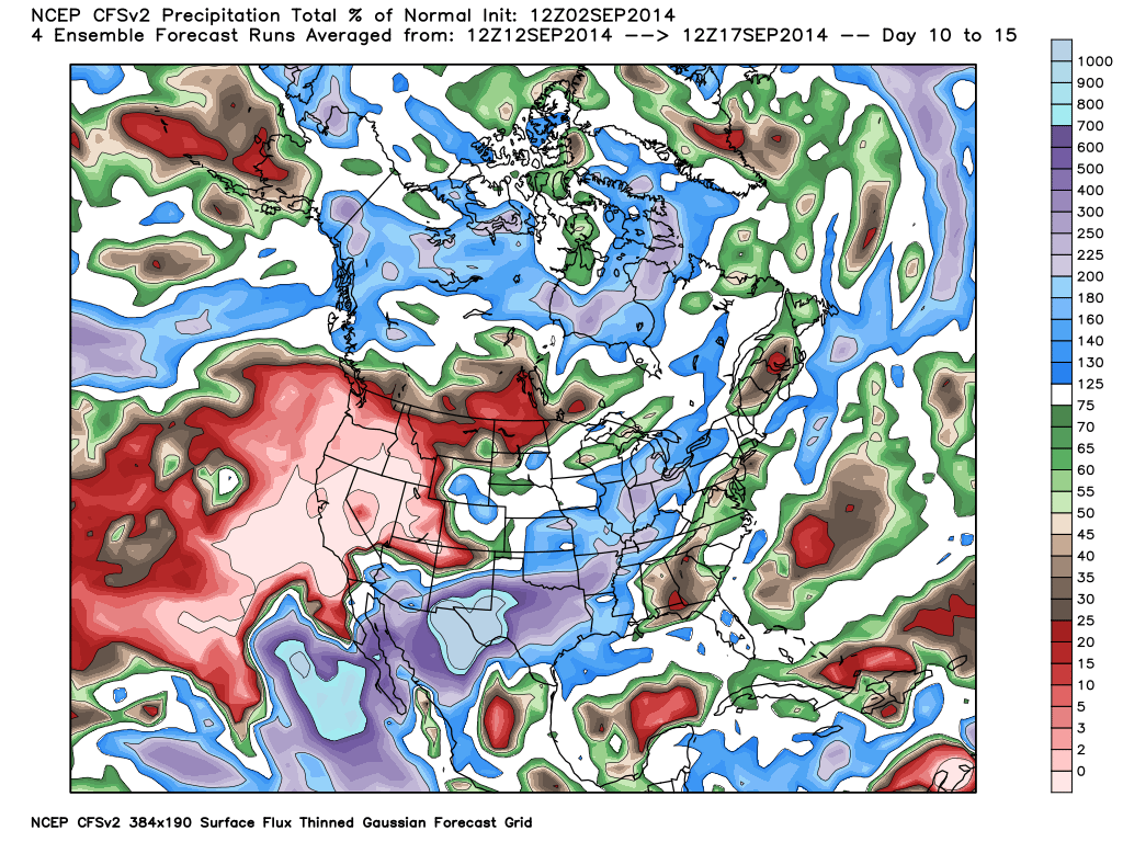
The CFSv2 also suggests precipitation runs 150%-200% of normal levels through mid September.

cfs_tprecip_anom_noram_2014090212_61

As harvest begins across some Hoosier farm lands, note the increased wetness in the pattern through the upcoming 14 days, or so.

The region will remain in an active pattern through the next couple weeks, at least, as we lie in the battle ground between a stubborn southeastern ridge and an increasingly active early fall northern stream.  A wetter than normal mid west will ensue…

Permanent link to this article: https://indywx.com/2014/09/02/wet-pattern-looks-to-continue-into-mid-month/

Improving Weather Through The Day…

Tue.

Wed.

Thr.

Fri.

Sat.

Sun.

Mon.

 Status-weather-showers-day-icon

 Status-weather-clouds-icon

 Status-weather-clouds-icon

 Status-weather-showers-day-icon

 Status-weather-clouds-icon

 Status-weather-clouds-icon

 Status-weather-clouds-icon

67/ 80

60/ 83

64/ 87

69/ 89

55/ 73

49/ 73

51/ 76 

Decreasing Rain Coverage; Increasing Sunshine…A shield of moderate to heavy rain encompassed the state during the overnight.  This shield of rain is slowly moving east, southeast and we’ll be looking at improving weather through the day.  There’s still the chance of a widely scattered thunderstorm late morning or early afternoon as a frontal boundary slides through the region.

Sunny Days…As we progress through the mid and late week stretch, we’ll enjoy dry skies and plentiful sunshine.  Normal lows and highs are in the lower 60s and lower 80s this time of year, so we’ll be very close to that Wednesday before moderating temperatures take us warmer than average to wrap up the work week.

Late Week Cold Front; Autumn Feel This Weekend…A cold front will slice into the warm and humid air mass Friday evening and lead to the possibility of a broken line of strong to potentially severe thunderstorms.  A MUCH cooler air mass will then invade the region behind the boundary, leading to a true fall-like feel this weekend!

7-Day Precipitation Forecast:

  • 7-Day Rainfall Forecast:  0.50″ – 0.75″
  • 7-Day Snowfall Forecast: 0.00″

John Salewicz sent us this beautiful sunrise photo Saturday morning before storms invaded portions of central Indiana.  Thanks, John!

BwSIn32CIAAqYL7


Are you craving cooler air to go along with that early season pumpkin spice latte? You'll be in luck this weekend as a true fall-like air mass invades...

Are you craving cooler air to go along with that early season pumpkin spice latte? You’ll be in luck this weekend as a true fall-like air mass invades…

Permanent link to this article: https://indywx.com/2014/09/02/improving-weather-through-the-day/

Beneficial Steady Rains Coming Overnight…

I’m just getting settled back in from Auburn, AL, but wanted to update a couple of items before a complete 7-day post in the morning.

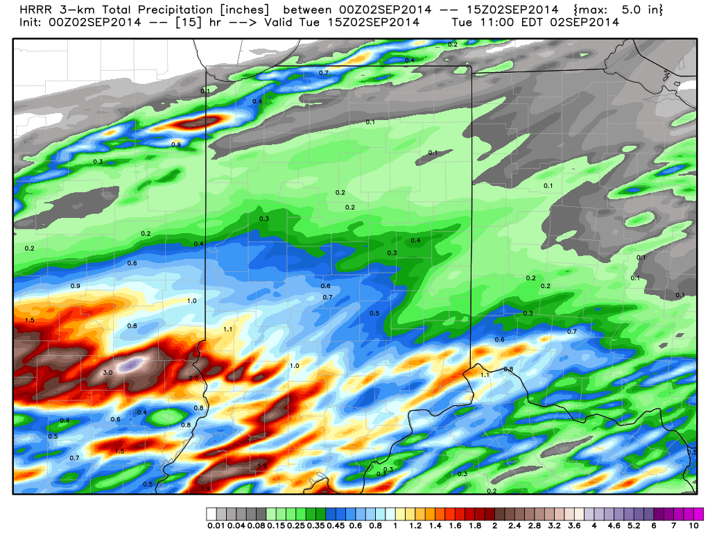
1.) Rain is continuing to become more widespread to our southwest and will overspread southern and central Indiana during the overnight into the wee morning hours Tuesday.  Most communities will accumulate 0.50″-1.00″ of needed rain, but a few locally heavier totals (closer to 2″) can be expected.  The HRRR forecast rainfall totals by 11am (when most of the rain will be ending across even our eastern counties) looks solid and we agree with this for the most part.  Note the heavier forecast totals across southwestern Indiana.

hrrr_t_precip_indy_16

2.)  A cold front will sweep the state Friday night into Saturday morning and result in a MUCH cooler weekend.  Temperatures will fall to well below normal levels (by 5-8 degrees on average) over the weekend and result in a perfect, early fall-like, feel!  Highs Saturday through Monday will likely only range in the lower to middle 70s with overnight lows in the lower 50s (a few readings into the 40s can be expected outside the city).

gfs_t2max_a_f_conus2_51

Permanent link to this article: https://indywx.com/2014/09/01/beneficial-steady-rains-coming-overnight/

Muggy And Potentially Stormy IndySportsReport.com Football Forecast

Good morning football fans! Your IndySportsReport.com high school football forecast promises to be a warm and humid one with storm potential… A warm front will lift north through the region…

You must be logged in to view this content. Click Here to become a member of IndyWX.com for full access.  Already a member of IndyWx.com All-Access?  Log-in here.

Permanent link to this article: https://indywx.com/2014/08/29/muggy-and-potentially-stormy-indysportsreport-com-football-forecast/

Slightly Less Humid; Still Can’t Rule Out A Storm…

Thr.

Fri.

Sat.

Sun.

Mon.

Tue.

Wed.

 Status-weather-showers-day-icon

 Status-weather-showers-day-icon

 Status-weather-showers-day-icon

 Status-weather-showers-day-icon

 Status-weather-showers-day-icon

 Status-weather-showers-day-icon

 Status-weather-clouds-icon

65/ 87

69/ 89

68/ 88

70/ 83

70/ 87

69/ 83

58/ 82 

Break In Humidity Won’t Last Long…A briefly drier air mass will filter into the region tonight into Thursday, but won’t last long.  Heat and humidity will return to wrap up the work week and move into the weekend.  A couple of storms will be possible Thursday, but most should remain rain-free.

Better coverage of showers and thunderstorms will develop Friday through Sunday.  We’re not talking about a weekend wash out by any means and there will be more dry hours than stormy.

Early Week Cold Front…A cold front will move through the area Tuesday evening and feature a cooler and drier brand of air for mid week.  Stormy times continue beforehand with shower and thunderstorms in our Monday and Tuesday forecast before we dry things out Wednesday.

7-Day Precipitation Forecast:

  • 7-Day Rainfall Forecast: 1.50″ – 2.00″
  • 7-Day Snowfall Forecast:  0.00″
A briefly drier air mass will move into the region late tonight into Thursday.  Humidity will return quickly to wrap up the work week.

A briefly drier air mass will move into the region late tonight into Thursday. Humidity will return quickly to wrap up the work week.

Permanent link to this article: https://indywx.com/2014/08/27/slightly-less-humid-still-cant-rule-out-a-storm/

Front Moves In This Evening…

Tue.

Wed.

Thr.

Fri.

Sat.

Sun.

Mon.

 Status-weather-showers-day-icon

 Status-weather-showers-day-icon

 Status-weather-clouds-icon

 Status-weather-showers-day-icon

 Status-weather-showers-day-icon

 Status-weather-showers-day-icon

 Status-weather-showers-day-icon

69/ 90

69/ 87

64/ 86

65/ 89

68/ 88

69/ 86

70/ 88 

Frontal Boundary Leads To Better Shower And Storm Coverage…A cold front will slip through central Indiana later this evening. This will be a focal point in better coverage of showers and thunderstorms today, especially this afternoon and evening.  Locally heavy downpours can be expected though rainfall amounts won’t be uniform (rarely are this time of year).

The boundary will move just south of the region Wednesday before stalling out. It’ll remain close enough to maintain mention of scattered thunderstorms into your mid week forecast with a drier forecast Thursday.  Temperatures will slip backwards a couple of notches and humidity values will improve to a degree mid week.

Stormy Times Return…After a somewhat drier time of things mid week, unsettled times will return late week into the Labor Day weekend. No all day rains are anticipated, but there will be periods of storminess into and through the weekend.

7-Day Precipitation Forecast:

  • 7-Day Rainfall Forecast: 1.50″-2.00″
  • 7-Day Snowfall Forecast: 0.00″

We received a couple colorful sunrise pictures this morning from Boone County, highlighted by cloud shots from storms ongoing to our north.  Thanks to John (T) and Paul (B) for these great photos this morning! 

Bv9ahviIYAAWd7Z

Bv9coEGCYAEcfGY


Rainfall totals will be far from uniform today, but more locally heavy downpours can be expected.

Rainfall totals will be far from uniform today, but more locally heavy downpours can be expected.

Permanent link to this article: https://indywx.com/2014/08/26/front-moves-through-this-evening/

Monday Evening Rambles…

1.) What exciting news we had the pleasure of sharing earlier this morning.  We’re pumped for our partnership with the fine folks over at IndySportsReport.com!

2.)  The steering current will keep us on our toes over the coming days as periodic storm clusters threaten.  It’s tough to pin point precise timing or location where these storm complexes will track, but it’s safe to say the overall region will be a focal point for additional storminess in the days ahead.

stormtrack


3.) Heat and humidity remain in the oppressive range through late week, before a potential punch of slightly cooler/ drier air.  Admittedly, ridges can be difficult to move this time of year and models are struggling in handling the details in the mid range.  We’ll keep an eye on things. As of now, we don’t see any sort of major push of cool/ refreshing air through at least the short to mid range period.  The Canadian is the most bullish on a period of cooler air as we get into September.  Stay tuned.

4.) We’ve made up for lost time in the rainfall department over the past week, or so.  What was, initially, a bone dry August has improved.  We’re now only running a little more than three tenths behind where we should be, officially.

Permanent link to this article: https://indywx.com/2014/08/25/monday-evening-rambles/

Continued Steamy; Afternoon Storms In Spots…

Sat.

Sun.

Mon.

Tue.

Wed.

Thr.

Fri.

 Status-weather-showers-day-icon

 Status-weather-showers-day-icon

 Status-weather-clouds-icon

 Status-weather-clouds-icon

 Status-weather-showers-day-icon

 Status-weather-showers-day-icon

 Status-weather-showers-day-icon

70/ 89

70/ 88

71/ 90

70/ 90

 71/ 90

70/ 88

68/ 85 

Steamy…Plan for plenty of heat and humidity this weekend.  Sunshine can be expected both days, but evening and nighttime storms will be scattered about the region.  We don’t anticipate as widespread coverage as compared to late last week, but some locally heavy downpours will be around Saturday and Sunday, including the chance of more localized flooding.

Hot, Hot, Hot…The ridge will expand early next week and this will essentially eliminate rain chances Monday and Tuesday (only isolated coverage at best).  Additionally, this will allow temperatures to reach the lower 90s for many communities across central Indiana.

Late Week Cold Front…We forecast more unsettled weather to develop late next week as a cold front draws closer to the area and the ridge begins to break down.  Scattered to numerous showers and thunderstorms lie ahead once past mid week, with best rain chances in the forecast period above likely arriving Friday.

7-Day Precipitation Forecast:

  • 7-Day Rainfall Forecast: 0.50″-1.00″ (locally heavier totals)
  • 7-Day Snowfall Forecast: 0.00″
Highs may reach 90 in a couple spots today, but we forecast Indy's official Saturday high at 89.

Highs may reach 90 in a couple spots today, but we forecast Indy’s official Saturday high at 89.

Permanent link to this article: https://indywx.com/2014/08/23/continued-steamy-afternoon-storms-in-spots/

Cooler To Open September?

As we move through the next week, we continue to think we’ll cool things off as we wrap up August. We’re not talking about any sort of major unseasonably cool…

You must be logged in to view this content. Click Here to become a member of IndyWX.com for full access.  Already a member of IndyWx.com All-Access?  Log-in here.

Permanent link to this article: https://indywx.com/2014/08/22/cooler-to-open-september/

IndyWx.com