Category: Forecast Discussion

Weekly Outlook: Cool And Overall Dry

We’re going to begin writing an overview on the weekends (Saturday or Sunday depending on what time allows) of the upcoming week ahead. This won’t serve as a substitute for…

You must be logged in to view this content. Click Here to become a member of IndyWX.com for full access.  Already a member of IndyWx.com All-Access?  Log-in here.

Permanent link to this article: https://indywx.com/2014/09/13/weekly-outlook-cool-and-overall-dry/

Storms Intensify Coming East

The stage is set for a stormy evening across central Indiana. The Storm Prediction Center (SPC) has issued a Tornado Watch for all of central Indiana until 9pm. We covered…

You must be logged in to view this content. Click Here to become a member of IndyWX.com for full access.  Already a member of IndyWx.com All-Access?  Log-in here.

Permanent link to this article: https://indywx.com/2014/09/10/storms-intensify-coming-east/

Active Weather Day

A strong fall cold front will slice into an increasingly warm and muggy air mass across our region tonight. Associated surface low pressure will track into the Great Lakes region.…

You must be logged in to view this content. Click Here to become a member of IndyWX.com for full access.  Already a member of IndyWx.com All-Access?  Log-in here.

Permanent link to this article: https://indywx.com/2014/09/10/active-weather-day/

Increasing Storm Chances Mid Week; Turning Cool Late Week…

Tue.

Wed.

Thr.

Fri.

Sat.

Sun.

Mon.

 Status-weather-showers-day-icon

 Status-weather-storm-night-icon

 Status-weather-showers-day-icon

 Status-weather-clouds-icon

 Status-weather-showers-day-icon

 Status-weather-clouds-icon

 Status-weather-clouds-icon

56/ 80

65/ 85

54/ 69

52/ 69

52/ 62

44/ 64

43/ 67 

Storms To Our Northwest This Morning…A complex of showers and embedded thunderstorms is moving into extreme northwest portions of the state this morning.  We have a very dry and stable air mass in place locally and these storms will weaken as they continue to sag southeast.  Most will remain rain-free today, but some light rain will be possible across northwestern and north-central portions of the state later this morning. (NOT a big deal).

Severe; Heavy Rain Threat Wednesday…A strong cold front will push into central Indiana Wednesday night. A warm and humid air mass will be in place and as the front moves through the region, widespread showers and thunderstorms will move over the area.  Locally heavy rainfall will be likely and embedded strong to severe thunderstorms will be possible.  Damaging wind and hail is our biggest concern, but a quick spin-up tornado can’t be ruled out.  We target Wednesday evening and nighttime for greatest chances of thunderstorms across our immediate area.

MUCH Cooler…An October-like air mass will filter into the region late week and as we go into the weekend.  A reinforcing shot of cool air will arrive Saturday with a passing shower possible.  Hope you’re ready for some true fall-like weather!

7-Day Precipitation Forecast:

  • 7-Day Rainfall Forecast: 1.50″ – 2″
  • 7-Day Snowfall Forecast: 0.00″

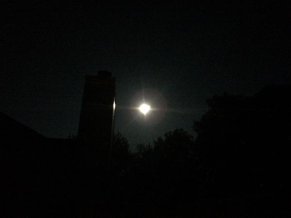
Hopefully you had a chance to see the last ‘super moon’ of the year last night.  John Salewicz and Brian Jessen caught the super moon in Zionsville (top) and Brownsburg (bottom).  Thanks, guys!

BxFeLeoCIAAfrk8.jpg-large

BxDquNcIQAAZpGm


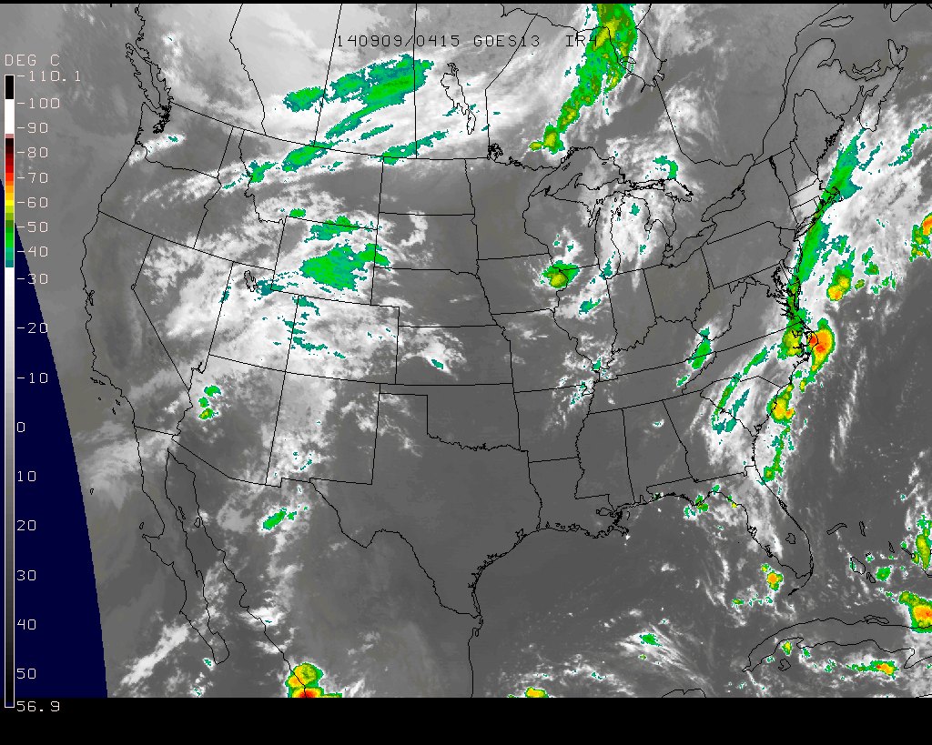
Blow off clouds will move into central and northern portions of the state this morning as a weakening area of showers and thunderstorms pushes closer.

Blow off clouds will move into central and northern portions of the state this morning as a weakening area of showers and thunderstorms pushes closer.

Permanent link to this article: https://indywx.com/2014/09/09/increasing-storm-chances-mid-week-turning-cool-late-week/

Stormy/ Rainy Wednesday Shaping Up…

The Storm Prediction Center continues to outline our region for severe potential Wednesday. Early indications suggest we’re eyeing another evening and nighttime storm threat, but there remain questions in regards…

You must be logged in to view this content. Click Here to become a member of IndyWX.com for full access.  Already a member of IndyWx.com All-Access?  Log-in here.

Permanent link to this article: https://indywx.com/2014/09/08/stormy-rainy-wednesday-shaping-up/

Nice Now, But Stormier Times Loom…

What a beautiful Sunday underway across central Indiana. We made the suggestion earlier today to get outside and watch the opening Sunday of NFL if at all possible (btw, we…

You must be logged in to view this content. Click Here to become a member of IndyWX.com for full access.  Already a member of IndyWx.com All-Access?  Log-in here.

Permanent link to this article: https://indywx.com/2014/09/07/nice-now-but-stormier-times-loom/

Gearing Up For A Busy Weather Week…

Sun.

Mon.

Tue.

Wed.

Thr.

Fri.

Sat.

 Status-weather-clouds-icon

 Status-weather-clouds-icon

 Status-weather-showers-day-icon

 Status-weather-storm-night-icon

 Status-weather-showers-day-icon

 Status-weather-clouds-icon

 Status-weather-clouds-icon

54/ 75

53/ 78

52/ 81

63/ 85

58/ 71

50/ 65

45/ 64 

Beautiful Close To The Weekend…Canadian high pressure will supply plentiful sunshine and pleasantly cool temperatures as we close out the weekend.  Even though today is the first Sunday to the NFL season, we’d suggest finding a way to watch your favorite game outside.

Lots of sunshine and mild temperatures continue Monday.

Mid Week Heavy Rain And Storms…A warm front will move north through central Indiana Tuesday and supply an increasingly humid feel to our air mass.  As the warm front lifts north, a couple showers or isolated thunderstorms will be possible Tuesday afternoon/ evening.  Most communities should remain rain-free, however.

Much better chances of showers and thunderstorms will arrive Wednesday as an area of low pressure and associated strong cold front impact the state.  Some of the storms could reach severe levels and locally heavy rainfall is also a good bet.  Stay tuned.

Bring Out The Jackets…A big push of unseasonably chilly air will blow into town as we wrap up the work week and head into next weekend. Well below normal temperatures will combine with sunny skies to create a classic fall weekend.  May not be a bad idea to plan on a pot of chili at some point next weekend… Just sayin’!

7-Day Precipitation Forecast:

  • 7-Day Rainfall Forecast: 1.5″ – 2″
  • 7-Day Snowfall Forecast: 0.00″

A little rain didn’t dampen the spirit of those in the Zionsville Fall Festival parade Saturday.  Thanks to John Salewicz for the photo!

Bw5HntqCAAAv0VI.jpg-large


D6

Craving some truly chilly autumn air? Hang in there for late week. Well below normal temperatures (more like October levels) will blow into town later this week.

Permanent link to this article: https://indywx.com/2014/09/07/gearing-up-for-a-busy-weather-week/

IndySportsReport.com Football Forecast Highlights Nighttime Storms…

Good morning football fans (best time of year, IMO)!  Your IndySportsReport.com High School Football Forecast features one more warm and humid evening highlighted by an increasingly stormy look as the evening transitions into the nighttime hours.

A cold front will slice into a very warm and humid air mass Friday night.  After a mostly quiet weather day across central Indiana, conditions will begin to go downhill Friday evening and night as the front draws closer.  We’ll monitor a line of thunderstorms approaching the region later tonight and a few of these could be strong to severe.  This shouldn’t be a major severe weather episode, but it only takes one strong to severe storm to make a mess of things.

We'll target 7p to midnight for a line of strong to potentially severe storms to move through central Indiana. Folks attending high school football games should monitor radar and weather conditions.

We’ll target 7p to midnight for a line of strong to potentially severe storms to move through central Indiana. Folks attending high school football games should monitor radar and weather conditions.

Dew points will be oppressive (in the lower 70s) and lead to a muggy feel.  Precipitable water values will reach 2″ in spots and suggest a locally heavy rainfall threat within the stronger storms.

hires_pwat_indy_34

Official IndySportsReport.com high school football forecast for Friday, Sept 5th:

Increasingly cloudy, warm, and humid.  Coverage of showers and thunderstorms will increase from north to south through the evening and nighttime hours.  A few of the storms may become strong to severe and produce vivid cloud-to-ground lightning, locally heavy rain, and strong winds.  Rainfall potential tonight will range from 0.25″ to 0.50″, but some local downpours may push totals closer to 1″ in localized spots.  Temperatures will begin in the mid to upper 80s before slowly falling through the game.

Permanent link to this article: https://indywx.com/2014/09/05/indysportsreport-com-football-forecast-highlights-nighttime-storms/

1-2 Punch Of Cool Coming…

September so far has been dominated by a southeast ridge, presenting a warmer and more humid than average feel to our air- stark contrast from the better part of the…

You must be logged in to view this content. Click Here to become a member of IndyWX.com for full access.  Already a member of IndyWx.com All-Access?  Log-in here.

Permanent link to this article: https://indywx.com/2014/09/04/1-2-punch-of-cool-coming/

Hot And Humid Before A Big Weekend Cool Down…

Thr.

Fri.

Sat.

Sun.

Mon.

Tue.

Wed.

 Status-weather-showers-day-icon

 Status-weather-showers-day-icon

 Status-weather-showers-day-icon

 Status-weather-clouds-icon

 Status-weather-clouds-icon

 Status-weather-clouds-icon

 Status-weather-showers-day-icon

65/ 87

69/ 89

59/ 73

52/ 73

51/ 76

52/ 77

57/ 76 

Watching Storms To Our Northwest This Morning…Today is a bit of a tricky forecast.  A complex of showers and thunderstorms is tracking through northern Illinois this morning and we’ll monitor this area of showers and storms in the event it begins to shift south of a due east track.  Additionally, outflow boundaries from this complex may trigger additional development of showers and thunderstorms later today.  Best rain/ storm chances should remain across northern Indiana, but we’ll keep an eye on things.  With all of that said, we think most folks here across central Indiana will remain rain-free, including lots of sunshine today.

Cold Front Ushers In A Much Cooler Weekend…A cold front will move through the region early Saturday morning. Ahead of this boundary, a broken line of strong to severe thunderstorms will likely blow through central Indiana Friday night.  We continue to fine tune timing, but thinking at this point highlights 8p to 1a Friday night and Saturday morning (we’ll “tighten” that time line up later tonight).

A few left over showers are possible into Saturday along with a MUCH cooler, fall-like, feel that will continue into next week!

Big Blast Of Cool Air Mid Month…Good model agreement remains on a big blast of cool air blowing in later next week.  Once again, rain and storms will remain in the forecast as the strong cold front blows through.  Behind the boundary, some truly chilly air would arrive… More details to come as we move forward, but it may be a good idea to go ahead and pull those jackets and sweaters out if you haven’t already.

7-Day Precipitation Forecast:

  • 7-Day Rainfall Forecast: 0.50″ – 1.00″
  • 7-Day Snowfall Forecast: 0.00″
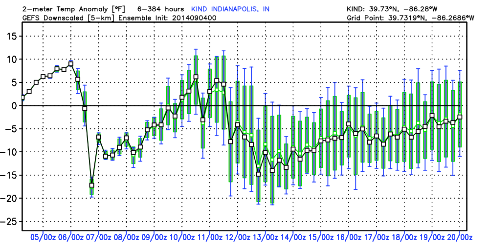
GEFS temperature anomalies over the next two weeks show the 1-2 punch of cool air coming. Time to think about pulling out those jackets!


GEFS temperature anomalies over the next two weeks show the 1-2 punch of cool air coming. Time to think about pulling out those jackets!
Permanent link to this article: https://indywx.com/2014/09/04/hot-and-humid-before-a-big-weekend-cool-down/

IndyWx.com