 Highlights:
- Sunshine finally returns
- Big time rain maker early next week
- Trending colder to open December
Sunshine Slowly Returns…We’ve been socked in with clouds, chilly conditions, and overall gloomy weather for the past several days. Thankfully, sunshine will eventually return this weekend. Today has started with overcast skies, but slow improvements should provide an increasingly sunny sky as the day wears on. Seasonable temperatures can be expected today.
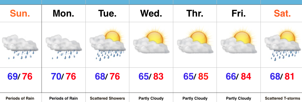
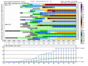
The second half of the weekend will feature more in the way of sunshine, but our next storm system will be awaiting on deck by this point. Southwest winds will turn increasingly breezy by the PM and clouds will quickly increase yet again. Those clouds will yield rain as early as the wee morning hours Monday (well before sunrise). Periods of heavy rain can be expected Monday and even a thunderstorm by afternoon/ evening.
Most of the heavy rain will fall Monday, but we’ll maintain mention of showers in our forecast Tuesday and Wednesday. A second wave of low pressure will develop along a pressing front the middle of next week and spread moisture northeast. The “leader” storm system is much easier to forecast than the “follower” in this scenario. The details are muddy at this point concerning the extent of how far west precipitation can make it. Know that we’re keeping a close eye on things. For the sake of this particular forecast, we’ll include mention of rain showers mixing with snow showers as colder air moves in Thursday. Stay tuned.
The end of the week will feature a colder trend as we usher in December.
One final item on the agenda this morning- with this being Iron Bowl Saturday, we can’t leave you without wishing you an energetic WAR EAGLE!
Upcoming 7-Day Precipitation Forecast:
- Snowfall: Trace
- Rainfall: 1.25-1.75 (locally heavier totals)
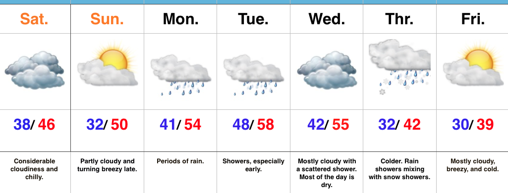
 2.) A cold front will pass through our neck of the woods as we put a wrap on the work week. While moisture is limited with the front, a much cooler air mass will greet us out the door Saturday morning. A light shower is possible Friday afternoon or evening, but this won’t be a big deal and most high school football games will remain dry. Temperatures Saturday morning will be in the 40s with lingering low clouds and areas of fog possible. We should shake the morning low cloudiness and allow for sunshine most of the day. Temperatures will remain crisp; generally in the lower to middle 60s for highs.
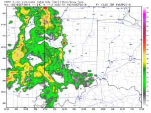 Periods of scattered showers and thunderstorms will continue Saturday. The good news? After the initial round of showers this afternoon, most high school football games could very well be dry tonight.
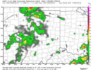
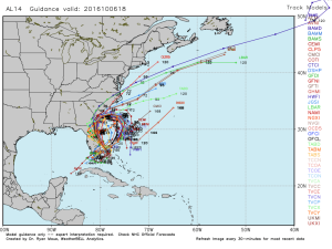
 It won’t rain the entire time Saturday, but scattered storms are a good bet through the day. Some locally heavy rainfall is likely, but rain amounts won’t be uniform. On average 0.75″-1″ is a good bet.
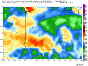
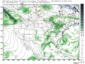
 Sunday will be the pick of the weekend as high pressure builds in and supplies a drier air mass. Flipping the page to next week, the big story will be a late season push of summer heat followed by a significant cold front next weekend. Behind this front, a true push of bonafide autumn air will push in. Sweaters and jackets will likely be needed as we put a wrap on September…