Updated 07.17.22 @ 9:15a
You must be logged in to view this content. Click Here to become a member of IndyWX.com for full access. Already a member of IndyWx.com All-Access? Log-in here.

Jul 17
Updated 07.17.22 @ 9:15a
You must be logged in to view this content. Click Here to become a member of IndyWX.com for full access. Already a member of IndyWx.com All-Access? Log-in here.
Permanent link to this article: https://indywx.com/video-wet-sunday-gives-way-to-a-dry-and-progressively-hotter-rest-of-the-week/
Jul 08
Updated 07.08.22 @ 7:30a
0.14″. That’s it in the rainfall department, officially recorded at IND, for the month so far. While several neighborhoods have seen much more rainfall than that, it reiterates just how dry it’s been here for most immediate central Indiana communities. In fact, we have to go all the way back to June 12th to find the last 24 hour period where IND recorded anything close to even half an inch of rain (0.49″).
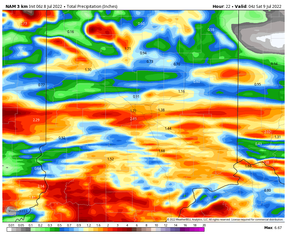
With all of that said, a combination of ingredients should come together to finally allow a widespread chunk of central Indiana to accumulate hefty rain totals as we get set to close out the work week.
I. We have added forcing from a cold front and wave of low pressure that will move along the boundary as it sags south this evening. This will aid in helping more widespread coverage of rain and thunderstorms fire, especially as we progress into the afternoon and evening.

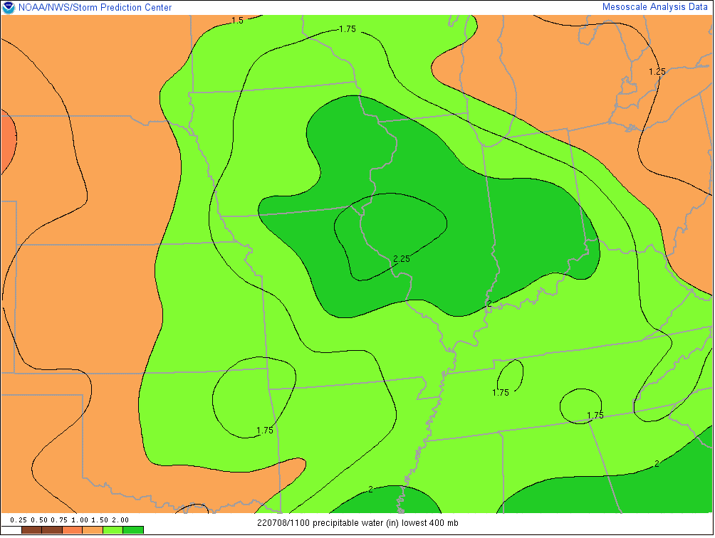
II. A truly tropical airmass engulfs the region this morning and this will remain in place until the cold front clears the area late tonight. Precipitable water values in excess of 2″ combined with dew points in the lower to middle 70s will allow rain and storms to feed off the juicy air this afternoon and evening. Rainfall rates of 2″+ per hour will be common in the heavier cells. Should storms train over the same areas, flash flooding will likely develop.

III. As the wave of low pressure moves across the state this afternoon and evening, it could help enhance the threat of severe weather, especially along and south of the I-70 corridor. A quick spin-up tornado isn’t out of the realm of possibility but the bigger severe threats appear to be from wet microbursts (damaging wind/ hail).

We anticipate many central Indiana neighborhoods to accumulate at least an inch of rain today with some communities seeing locally heavier totals. Again, where heavier cells train, localized flash flooding will develop.

Eventually the front will settle south and clear the state tonight. This will allow drier and MUCH less humid to return to the region just in time for the weekend. We expect plentiful sunshine, low humidity, and cooler temperatures to dominate through the day Monday.
Permanent link to this article: https://indywx.com/central-indiana-poised-to-finally-cash-in-on-heavy-rains/
Feb 17
Updated 02.17.22 @ 7:35a
You must be logged in to view this content. Click Here to become a member of IndyWX.com for full access. Already a member of IndyWx.com All-Access? Log-in here.
Permanent link to this article: https://indywx.com/video-spring-fling-early-next-week-but-a-lot-of-winter-is-left-in-the-tank/
Feb 16
Updated 02.16.22 @ 8p
Type: Impactful Wintry Weather, Flooding, and Severe Storms

What: Impactful wintry weather; Localized flood threat; Severe storm potential downstate
When: Thursday
Temperatures: Lower 50s midnight Thursday crashing into the lower 20s by midnight Friday morning.
Wind: Variable 15-30 MPH
Blowing/ Drifting: Minimal (due to heavy, wet nature of the snow) across northern Indiana; non-existent elsewhere
Pavement Impacts: Plowing and salting will be required
Summary: A strengthening area of low pressure will move across the state Thursday afternoon, dragging a cold front southeast. Heavy rain will be widespread across the state Thursday morning. As cold air presses southeast, the 1st round of precipitation will transition to a wintry mix of sleet and freezing rain across far northern Indiana (along and north of a line from Rensselaer up to South Bend) mid to late morning. A secondary area of precipitation will then be blossoming off to our southwest and push northeast into the state through the afternoon. Central Indiana and points south will continue to deal with rain, along with falling temperatures, while downstate (Bloomington over to Greensburg and points south) gears up for the potential of severe t-storms in the 3p to 6p window. Any severe storms that do develop will be capable of producing damaging straight line winds.


Meanwhile, cold air will continue to settle southeast and lead to a transition from heavy rain to a wintry mix of sleet and freezing rain for northern Indy ‘burbs towards 3 or 4p, eventually making it into the city, itself, in time for the evening rush.
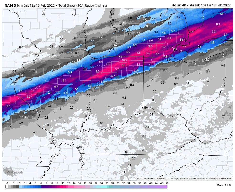
Before the transition to a wintry mix, widespread 1”-2” of rain with locally heavier amounts can be expected across central Indiana, including Indianapolis. Further north, heavy snow can be expected, including widespread 4”-8” amounts with locally heavier totals. I think the latest high resolution NAM is handling snowfall numbers quite well this evening and don’t see any reason to disagree with these numbers.

A dusting to coating of snow (less than half an inch) is possible into the city as the sleet and freezing rain mixture transitions to the white stuff prior to precipitation exiting the region Thursday night. As temperatures crash, a “flash freeze” is possible even into southern Indiana by Friday morning.
Confidence: High
Next Update: 7:30a Thursday
Permanent link to this article: https://indywx.com/client-brief-significant-and-multifaceted-storm-impacts-region-thursday/
Feb 16
Updated 02.16.22 @ 7:21a
You must be logged in to view this content. Click Here to become a member of IndyWX.com for full access. Already a member of IndyWx.com All-Access? Log-in here.
Permanent link to this article: https://indywx.com/video-significant-storm-delivers-a-wide-range-of-impacts-mjo-influence-on-the-longer-range/