Updated 03.31.25 @ 7:59a In the immediate term, the focus is squarely on Wednesday evening and night as another significant severe weather outbreak looks to be on deck, including damaging…
You must be logged in to view this content. Click Here to become a member of IndyWX.com for full access. Already a member of IndyWx.com All-Access? Log-in here.
Permanent link to this article: https://indywx.com/video-midweek-severe-threat-transitions-to-flooding-concerns-late-week-pattern-takes-a-colder-shift/
Updated 03.30.25 @ 7:57a We’re tracking 2 storm systems that will deliver a risk of severe weather, including tornadoes, this afternoon/ evening and again Wednesday. The pattern then will shift…
You must be logged in to view this content. Click Here to become a member of IndyWX.com for full access. Already a member of IndyWx.com All-Access? Log-in here.
Permanent link to this article: https://indywx.com/video-week-opens-with-a-couple-of-severe-threats-before-we-transition-focus-to-excessive-rain-turning-much-colder-next-week/
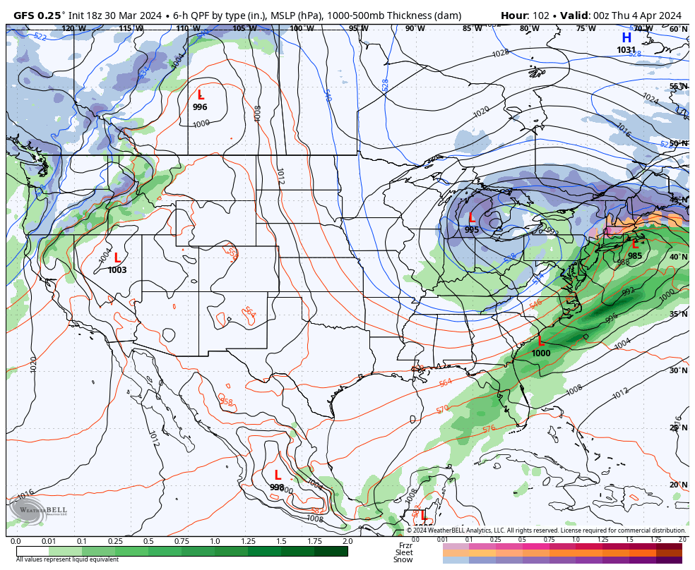
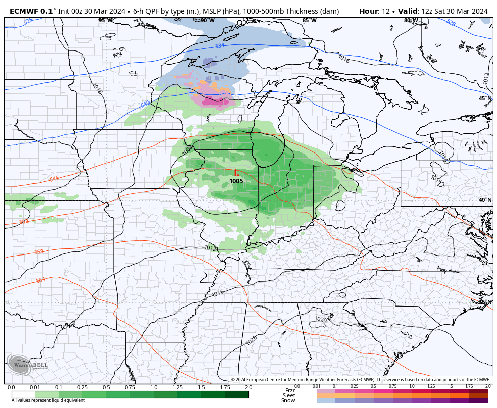
Updated 03.28.25 @ 8:15a The pattern is absolutely loaded over the course of the upcoming 10 days (and likely beyond). We’ll go from running below normal in the rainfall department…
You must be logged in to view this content. Click Here to become a member of IndyWX.com for full access. Already a member of IndyWx.com All-Access? Log-in here.
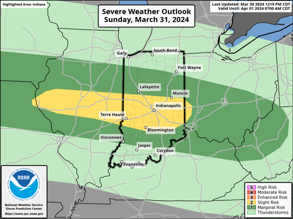
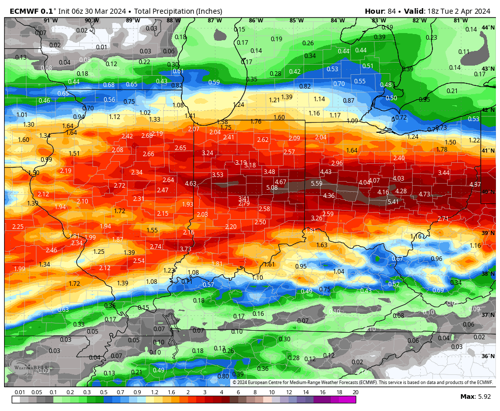
There’s not much, if anything, to change regarding the setup and anticipated outcome of the Easter Sunday through Tuesday timeframe. Periods of heavy rain will get going Sunday PM and we’ll also need to watch for the threat of severe storms not only tomorrow afternoon/ evening but again Monday.
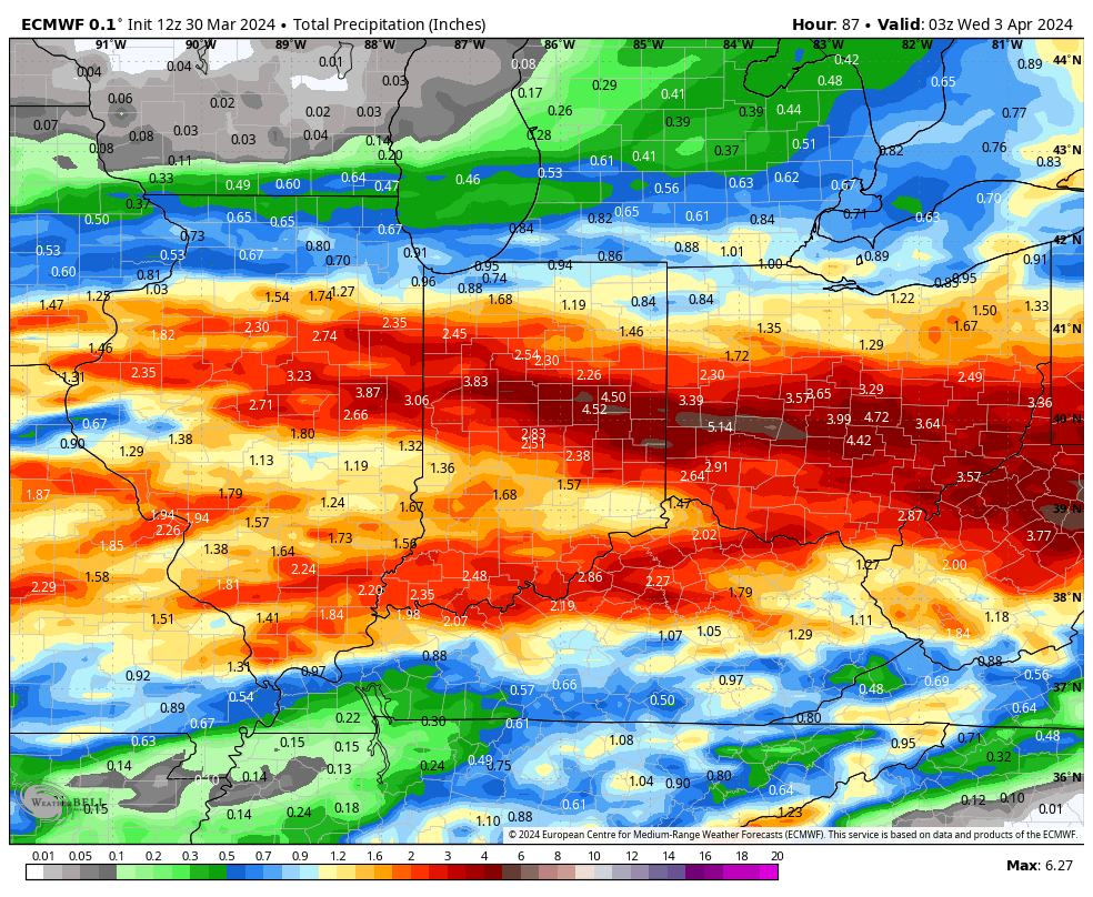
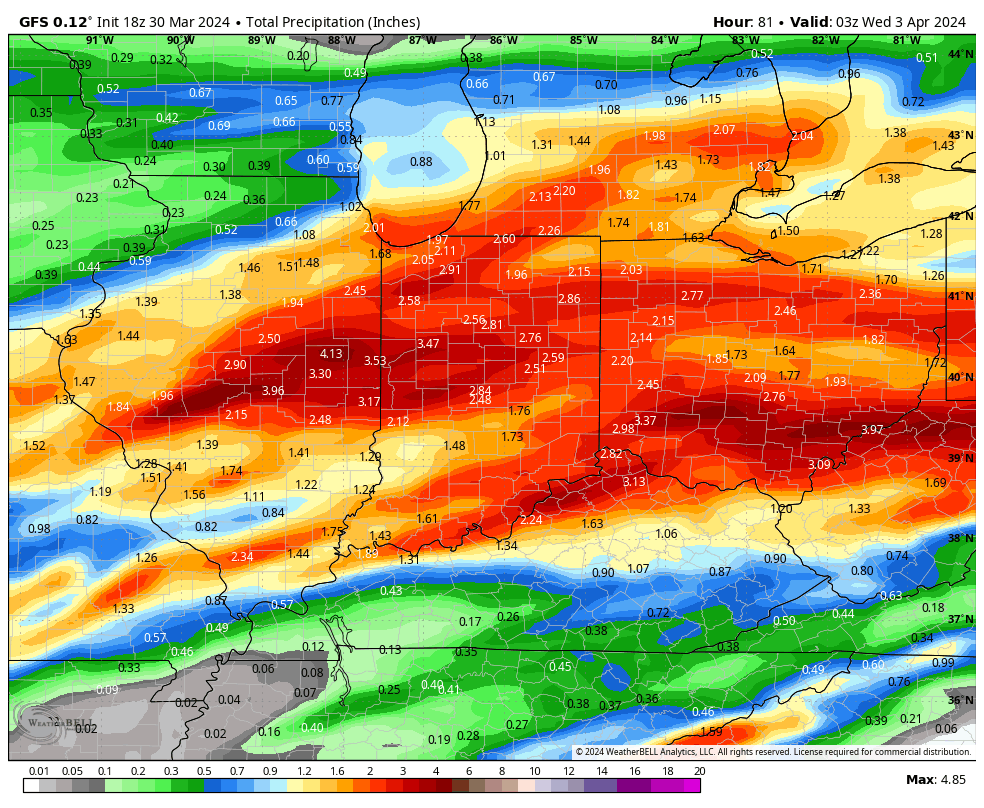
Midday models are latching onto a widespread 2”-4”+ event.
The Storm Prediction Center (SPC) has increased the threat area tomorrow afternoon. Large hail is greatest concern but an isolated tornado can’t be ruled out.
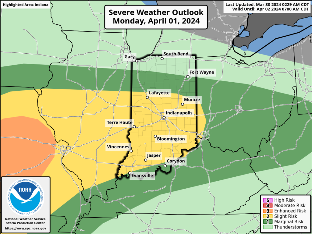
All modes of severe are on the table Monday, including tornado potential once again.
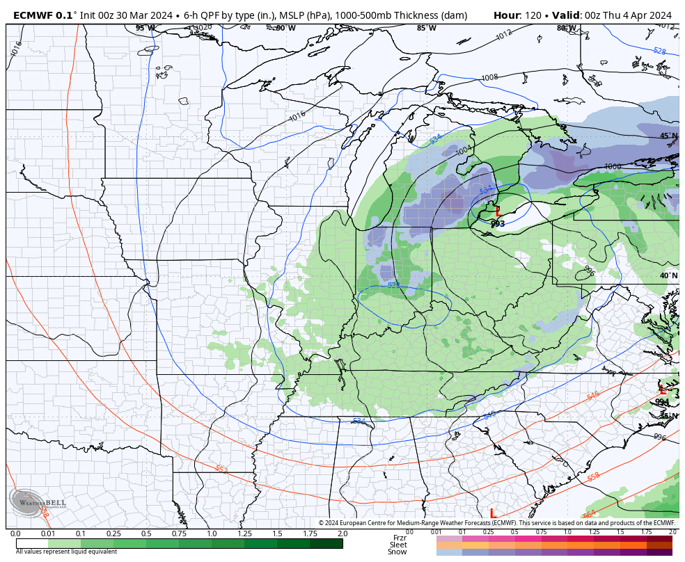
If all this wasn’t enough already, a much colder air mass will plunge into the region by midweek allowing rain to mix with and change to wet snow Wednesday evening into Thursday morning. The snow may even be heavy enough for slushy accumulations in spots.
Spring at its finest across the great Hoosier state…
The combination of a quasi-stationary frontal boundary, increasingly warm and humid air, and multiple waves of low pressure riding along the aforementioned boundary will lead to several rounds of locally heavy rain and also pose a strong to severe storm risk as we go through the early stages of the new week.
Precipitable water values (PWATs) will approach 1.5” to 2” at times early week (a tough feat to come by this time of year). This only raises confidence in the opportunity for this setup to generate periods of heavy, and eventually excessive, rainfall.
Widespread 3”+ totals can be expected by the time all is said and done, with locally heavier amounts.
If the heavy rain event wasn’t enough, we also need to be on guard for the threat of severe storms Sunday and Monday.
In particular, it’s Monday’s risk of severe that has us most concerned, including all modes (hail, wind, and a TOR threat). We recommend reviewing your family’s severe weather safety plan and make sure to have a way to receive any warnings that may be issued.
The heavy rain event will come to an end by Tuesday evening, but if we didn’t have enough to track already, we’ll add in the potential of rain to mix with wet snow Wednesday. Regardless, expect a much colder and blustery time of things as this bigger storm departs by midweek.