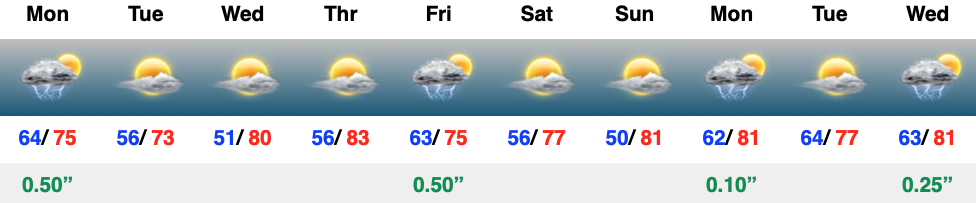
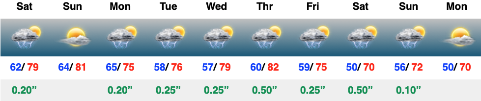
Category: Ensemble Discussion

Pre-Christmas Weather Rambles…

I. While we certainly aren’t talking about significant weather events between now and Christmas Day, there will be a couple of impulses of upper level energy that may be just strong enough to produce snow showers and flurries at times.  We’re tracking (2) weak disturbances that stand a chance to get a couple of snow showers going Sunday evening and again Christmas Day.  The one on Christmas, itself, will be a bit stronger and may have a shield of more organized precipitation- likely that would start as wet snow before transitioning to rain before ending.

II. A much stronger storm system will wrap up to our northwest Wednesday night and Thursday.  We’ll notice an increasingly strong southerly breeze during this time period and rain will be on the increase as we progress through the day Thursday.  The trade-off?  Highs between 55° and 60° to close the week- though those temperatures may actually come Thursday evening before cooler air begins to slip in here during the day Friday.

As things stand now, both the GFS and European models, courtesy of Weathermodels.com, aren’t overly excited on rainfall amounts with this storm system, but I think they’ll trend wetter as time goes on.  We’ll continue to forecast amounts between 0.50″ and 1″.

III. All attention is squarely focused on a significant pattern change that takes shape as we head into the new year.  As mentioned in previous posts and discussions, the transition is likely to be a stormy one, but it’s far too early to talk precipitation types.  A combination of ingredients appears to be aligning to create a colder than normal (and potentially significantly so) pattern at the traditionally coldest time of year (mid-Jan).

In the more immediate term, we note the latest GEFS showcases a classic “horse shoe” block that will favor a wintry regime across the east to open the new year- thanks to Tropicaltidbits.com.

Permanent link to this article: https://indywx.com/2018/12/22/pre-christmas-weather-rambles/

Deeper Look Into The Long Range…

You must be logged in to view this content. Click Here to become a member of IndyWX.com for full access.  Already a member of IndyWx.com All-Access?  Log-in here.

Permanent link to this article: https://indywx.com/2018/12/20/deeper-look-into-the-long-range/

New Month; New Pattern (In Some Aspects) Around The Corner…

October got off to a warm start, but unseasonably chilly conditions have dominated over the past couple of weeks.  In fact, we’re on a stretch of (12) consecutive days below average after the summer-like start.  The other common theme?  Dry, dry, dry.  Officially, IND is running close to 1″ below average through the first few weeks of the month.  Changes loom- at least to some extent.

We notice the ensemble data (both the European and GFS) is painting a more active, wetter regime as we move through early November.  Given the upper air pattern, we would tend to agree.

European data, courtesy of Weathermodels.com, paints a much more active picture early November.

GFS data, courtesy of Tropicaltidbits.com, shows the return of a wetter pattern for early November.

While confident on the return of wet conditions as we traverse the first week or two of November, data is struggling to get a handle on the PNA past the short-term.  The PNA, or Pacific North American Pattern, teleconnection is one of our favorites this time of year to “key in” on the medium range pattern.  While the NAO and AO get a lot of attention the deeper we get into the cold season, the PNA can be a tremendous tool during transition seasons.  We note latest data is trending significantly more towards a positive PNA (compared to previous runs)- which is a colder signal.

To no surprise, data has trended chillier during today’s 12z update.

To close, bank on a return of the wet conditions as we move into the mighty month of November.  From a temperature perspective, the forecast is much tougher for the first half of November.  As things stand now, we continue to favor a relaxation of the anomalous chill overall, but can certainly see where “pops” of cold air can easily sweep in behind what should be an active storm track from the mid-south up into the Mid West and Ohio Valley.  Stay tuned.

Permanent link to this article: https://indywx.com/2018/10/23/new-month-new-pattern-in-some-aspects-around-the-corner/

Welcome To Fall (Finally)!

You must be logged in to view this content. Click Here to become a member of IndyWX.com for full access.  Already a member of IndyWx.com All-Access?  Log-in here.

Permanent link to this article: https://indywx.com/2018/09/21/welcome-to-fall-finally/

VIDEO: Taste Of Fall Is Replaced With Resurgent Summer Heat…

You must be logged in to view this content. Click Here to become a member of IndyWX.com for full access.  Already a member of IndyWx.com All-Access?  Log-in here.

Permanent link to this article: https://indywx.com/2018/08/21/video-taste-of-fall-is-replaced-with-resurgent-summer-heat/

VIDEO: Friday Opens Quiet, But Ends Stormy For Some…

You must be logged in to view this content. Click Here to become a member of IndyWX.com for full access.  Already a member of IndyWx.com All-Access?  Log-in here.

Permanent link to this article: https://indywx.com/2018/08/10/video-friday-opens-quiet-but-ends-stormy-for-some/

VIDEO: Foggy Open To August; Discussing Rain Chances Ahead…

You must be logged in to view this content. Click Here to become a member of IndyWX.com for full access.  Already a member of IndyWx.com All-Access?  Log-in here.

Permanent link to this article: https://indywx.com/2018/08/01/video-foggy-open-to-august-discussing-rain-chances-ahead/

Time To “Buck The Trend” On The Dry Summer?

Summer has been dry, thus far, for central Indiana.  With the last month of meteorological summer on the doorstep, will that continue?

Before we discuss further, let’s check-up on precipitation anomalies at IND (through July 28th).

  • June: finished the month 0.26″ below average
  • July: 2.69″ below average, month-to-date
  • (This comes after a May that featured a 3.63″ deficit).

We have discussed the upcoming shift to a wetter regime that will develop Sunday into the first half of next week.  A Saturday evening update continues to point towards increasing rain chances arriving as we rumble into Sunday evening.  As expected, this morning’s high resolution NAM was likely a bit too excited on the initial wave of moisture and has come around to a “more realistic” idea in our opinion.

Rain and embedded thunder will likely be rather widespread early Monday, especially across the southern half of the state.

Data continues to point towards the greatest coverage of rainfall arriving Monday night and Tuesday.  We still expect a widespread 1″ to 2″ rain for central Indiana before things begin to wind down mid to late week.  There will be locally heavier totals.

As we look ahead, we think the balance of the month of August will feature an upper ridge across the western portion of the country that will keep our immediate region in an active northwesterly flow aloft.  Perhaps the GEFS is seeing this best at the moment (important to note the model has been consistent with respect to run-to-run updates as of late).  This is a wet signal this time of year…

The model has support of a return to wetter times as noted from the latest JMA Weeklies, CFSv2, and European ensemble.

While the cool will relax as we rumble past the first couple days of the month (we’re in the “dog days” after all), I still think the worst of the heat is over for the summer and the headline for August will likely be a situation where we begin to make up for lost time in the precipitation department.  That upper ridge centered to our west in the means will likely result in a continuation of rather active times from a precipitation perspective through the month and our idea is that we finish August with above normal precipitation across central Indiana for the first time since April…

Permanent link to this article: https://indywx.com/2018/07/28/time-to-buck-the-trend-on-the-dry-summer/

VIDEO: Closing Out July And Looking Ahead To August…

You must be logged in to view this content. Click Here to become a member of IndyWX.com for full access.  Already a member of IndyWx.com All-Access?  Log-in here.

Permanent link to this article: https://indywx.com/2018/07/22/video-closing-out-july-and-looking-ahead-to-august/

Looking Ahead…

With the first week of July in the books, we wanted to touch base on what we believe the remainder of the month has in store. In short, there’s no change to our ongoing idea of a transitional period July 10th through 20th followed by a more pronounced shift to cooler temperatures as we wrap up the month: roughly the 21st through 31st.

In some aspects, the transitional period has already begun- just a couple of days earlier than originally expected. Thankfully, the early month heat has subsided, giving way to a couple days of very refreshing conditions. After a slight rebound in humidity to open the work week, a cold front will slip through central Indiana Tuesday. This will offer up the potential of a thundershower followed by a return of the refreshing easterly flow we’re currently enjoying.

Our latest 7-day forecast reflects this slightly cooler air mass and the associated “pull back” in humidity over the midweek stretch.

Heat and humidity will then build again during the late week period ahead of an approaching cold front that will likely offer up more in the way of scattered to numerous storms next weekend.  Note the “ups and downs” over the upcoming 7-10 day period.  While sustained heat isn’t expected, there will be a few hot days thrown in the mix for good measure as the overall pattern works through its’ transition.

After the upcoming 10-day stretch, we notice the data becoming more aligned in a manner that will pull the worst of the heat, relative to average, west and put the Mid West and Ohio Valley in a position to turn cooler with more authority, as well as more active to close the month.  We have to give a hat tip of the cap to the JMA Weeklies for first seeing this a couple of weeks back, and while we weren’t ready to jump on the idea of a sustained trough setting up over the Great Lakes in what will now be the Week 2-3 time period, the model did see the pull back before the majority of other data.

The new GEFS this afternoon sees something similar:

Again, along with the expected cooler shift, the model is painting a wet pattern emerging as we put the wraps on the month of July.  With the developing northwest flow aloft, it’s tough to disagree with this overall more active look.

Enjoy this pleasant early-July weather and have a great weekend!  Additional updates will arrive here and on our social media outlets throughout the weekend.

Permanent link to this article: https://indywx.com/2018/07/07/looking-ahead-2/

IndyWx.com