Storms Rumble In This Evening; Warm Open To Meteorological Summer…

A stalled frontal boundary remains draped across the Ohio Valley this morning.  We note ongoing showers across northern Indiana and Illinois, along with considerable cloudiness in association with the front.  Also of interest is the disturbed weather off the FL peninsula this morning.  Models differ on the evolution of things, but both the GFS and European model suggest we may have a tropical depression or weak tropical storm on our hands by the Memorial Day weekend.  Is it more of a threat to the central Gulf Coast region, such as the European implies, or more of a Carolina event?  It’s simply too early to know, but it’ll be fun to watch things play out this week.

Back here on the home front, a quiet start to our Monday will turn stormy at times this evening as the front nears.  We think best coverage of showers and thunderstorms will come between 5p and 10p.  There will be some winners and losers when it comes to rainfall amounts by midnight.  Some can expect over an inch in the stronger storms while others may only see a tenth of an inch, or so.  Something that must be taken into forecasts moving forward is the tendency of most model data (high resolution and global data alike) to “over forecast” rainfall amounts as of late.  Also of note is for the potential of a couple of strong to severe storms to develop this evening.  We always have to be wary of fronts draped across central Indiana as they’ve been known to help tornadic activity spin up.  We’ve lost count of how many slight risk days with warm fronts nearby that turn busy…  If you’re planning to be outdoors this evening, please have a means of receiving the latest watches and potential warnings that may be issued.

High pressure will build in for the midweek period and supply plentiful sunshine along with continued warmer than average conditions.  Overnight lows will fall into the upper 50s (couple of degrees above average) with the drier air mass in place, but afternoon highs will continue to climb into the lower and middle 80s (around 10 degrees above average).

Good news this morning for all of the Race Day and Memorial Day weekend activities is that forecast models are backing off (seeing a common theme?) on the magnitude and overall coverage of showers and thunderstorms associated with our next system.  While we’ll maintain widely scattered thunderstorms in our Saturday-Monday forecast, much more of the time period will be free of any rain and storm activity.

Longer term, thoughts are shifting towards the open to meteorological summer (where is this year going?!).  The GFS ensemble suggests the overall warm pattern remains intact as we open a new season with widespread warmth expected through the first few days of the June.

More Unsettled Weekend Ahead And Closing Out May…

An upper level low pressure system will track northeast today into tonight, and as it does, look for more numerous showers and embedded thunder to develop.  Some localized heavier downpours are a good bet this evening across central Indiana.

Otherwise, look for considerable cloudiness and highs topping out in the lower 70s today.

While we’ll have to contend with a few showers Saturday, overall, the day should be drier compared to today and what lies ahead Sunday.  Speaking of Sunday, we’re monitoring the potential of a couple of storms reaching strong to severe levels to close the weekend.  The Storm Prediction Center includes central portions of the state in a “marginal” risk of severe with their update Friday morning.  It wouldn’t surprise us if a portion of the marginal risk is upgraded to a “slight” risk in future updates.  We’ll fine tune storm timing over the next 24 hours.

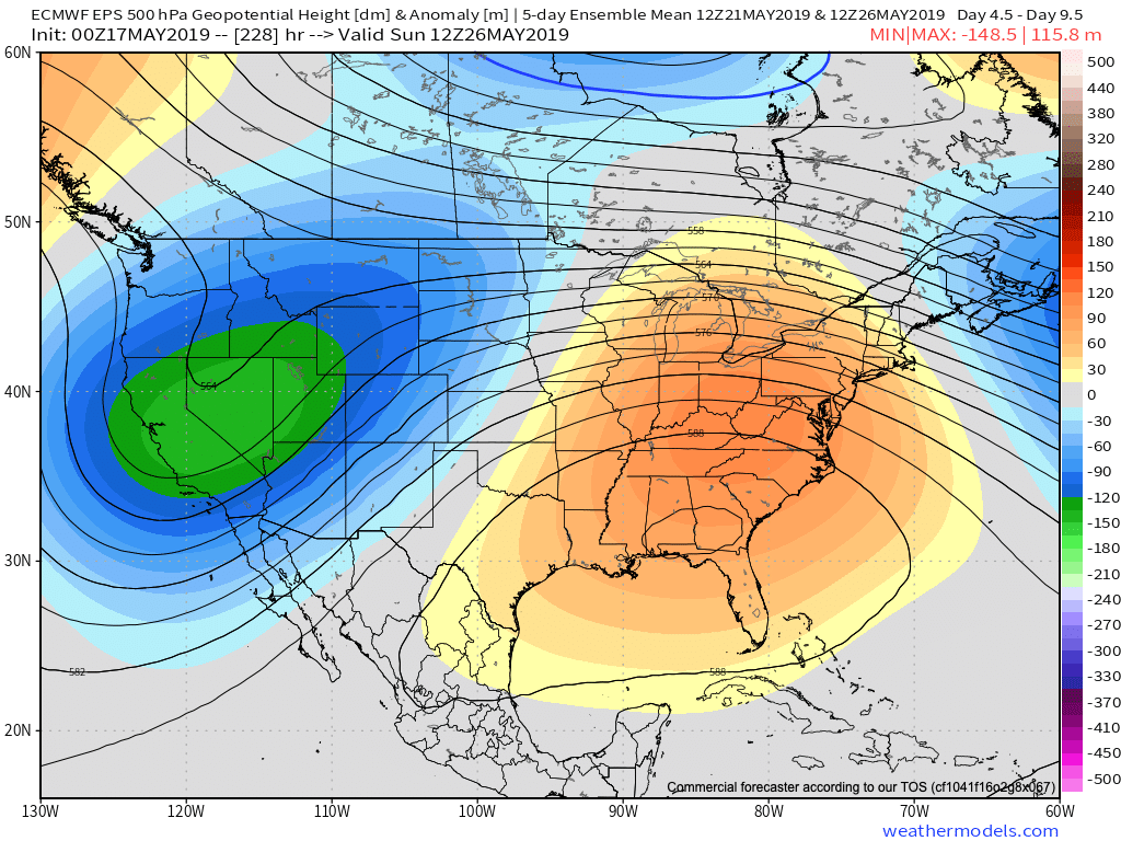
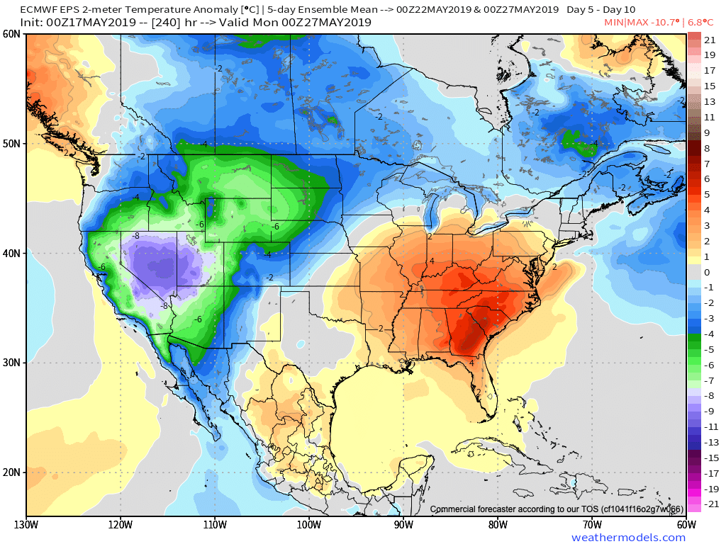
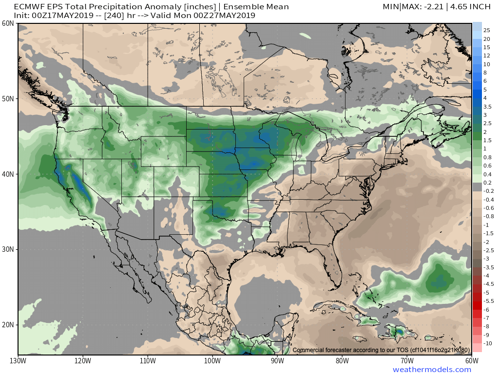
As we look ahead to the end of May, there really aren’t any significant changes to the overall warmer than normal theme we’ve enjoyed so far this month.  Longer range guidance off of the European ensemble continues to support broad scale upper ridging across the Mid West and Ohio Valley and a corresponding warmer than average regime.  From a precipitation perspective, the next couple of weeks do look more active compared to the dry start to the month.  Case in point, the balance of the upcoming week will be dominated by a stalled frontal boundary.  While we’ll have to fine tune exactly where the front stalls, daily chances of showers and thunderstorms (scattered fashion) can be expected.

Wednesday Morning Rambles…

1.) A narrow, but persistent band of downpours continues to fall just south of the metro this morning.  Places from Martinsville to Trafalgar and Shelbyville are enjoying needed rain this morning.

2.) Overall, a drier air mass will build into central Indiana today and Thursday (cooler, too) before moisture returns to close the week.  Scattered showers and embedded thunder are more likely Friday and again late Sunday into Monday.

3.)  Looking ahead, we notice a more active pattern is presented off the overnight GEFS model.  The heat ridge backs west and sets up a busy “ring of fire” pattern with a northwest flow aloft across our region.  We have a ways to go before developing consistency and overall confidence, but this is at least an encouraging sign.  The end result, should this come to fruition, would be a significantly wetter open to June.

Quick Evening Notes: Warm Pattern Grabs The Headlines In The Longer Range…

As we look over the 12z long range guidance, we see a common theme: warmer (dare I say “hotter”) than average.  Additionally, most data paints a drier than normal trend Days 10-20, as well.

The GEFS shows eastern ridging gaining control during the period which favors a warmer than normal pattern.  Consensus of other data is similar in the upper levels.

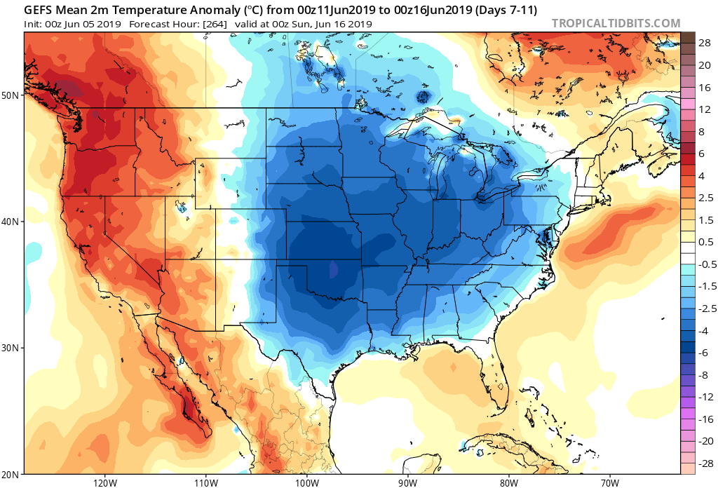
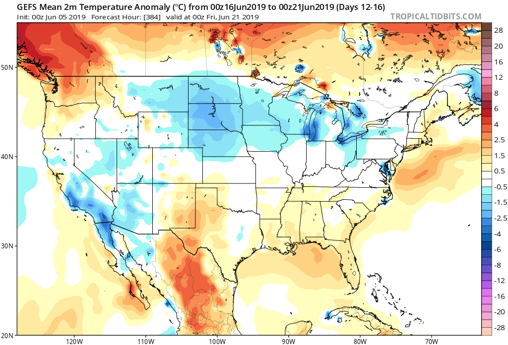
At the surface, all three major global models agree on warmth in the long range period, including the GEFS, EPS, and CFSv2:

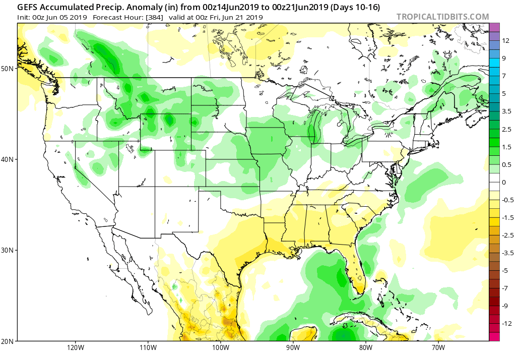
Guidance suggests below average precipitation during the period.  With broad scale ridging in place, we agree on a drier theme compared to normal.  While trying to put our finger on the flip from the prolonged cold to warmer was difficult to nail down from March and April, May always looked like a drier than average month from several weeks out.  (One note is the potential of active times across the Great Lakes region as “sudden summer” gains steam to the south and stubborn chill refuses to let go to our north.  The gradient would promote heavier than normal precipitation relative to average).

Given the agreement in the data, along with some additional pattern drivers, we continue to believe the medium to longer term period (including mid and late May) will feature an overall warmer than average pattern along with drier than normal conditions.

More on the short-term in the morning, including what will be a summer-like feel by late week.

VIDEO: Saturday Morning Thoughts On Late March…

In the midst of trying to keep Bo, our youngest golden doodle, from becoming a tremendous distraction in this morning’s video, here are some thoughts on what lies ahead over…

You must be logged in to view this content. Click Here to become a member of IndyWX.com for full access.  Already a member of IndyWx.com All-Access?  Log-in here.