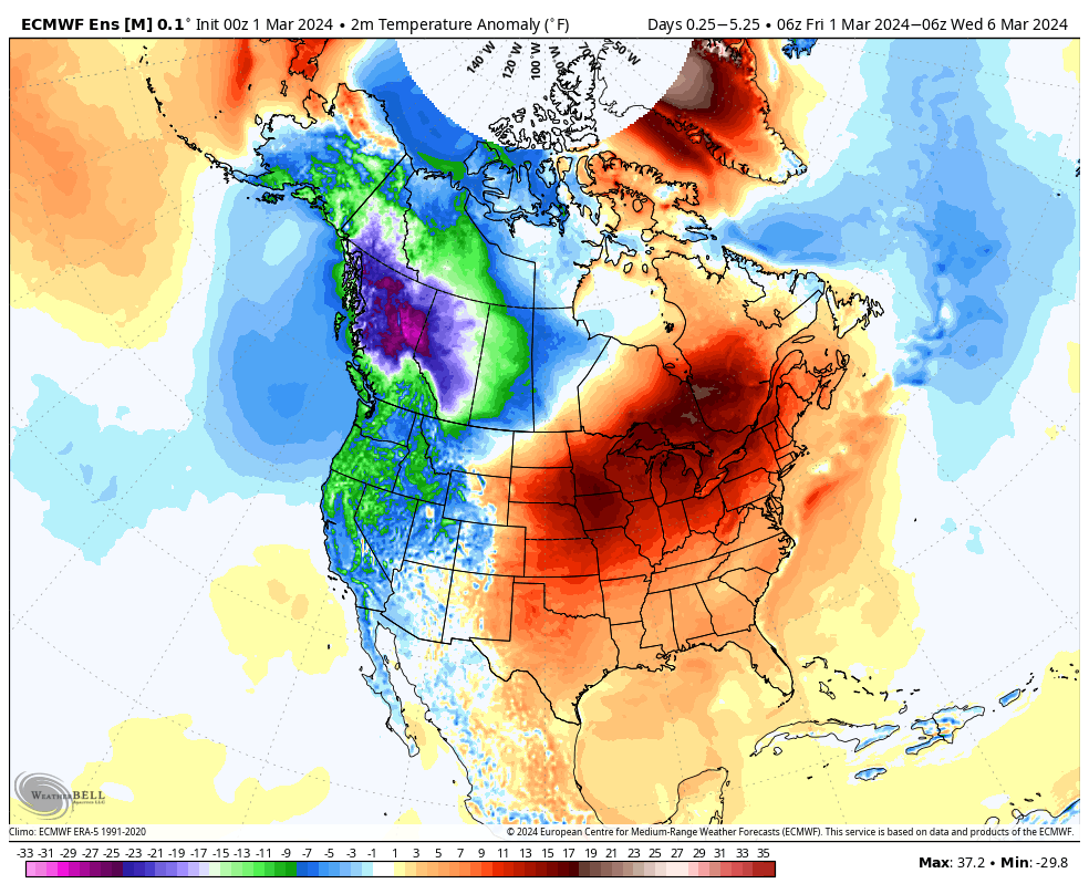
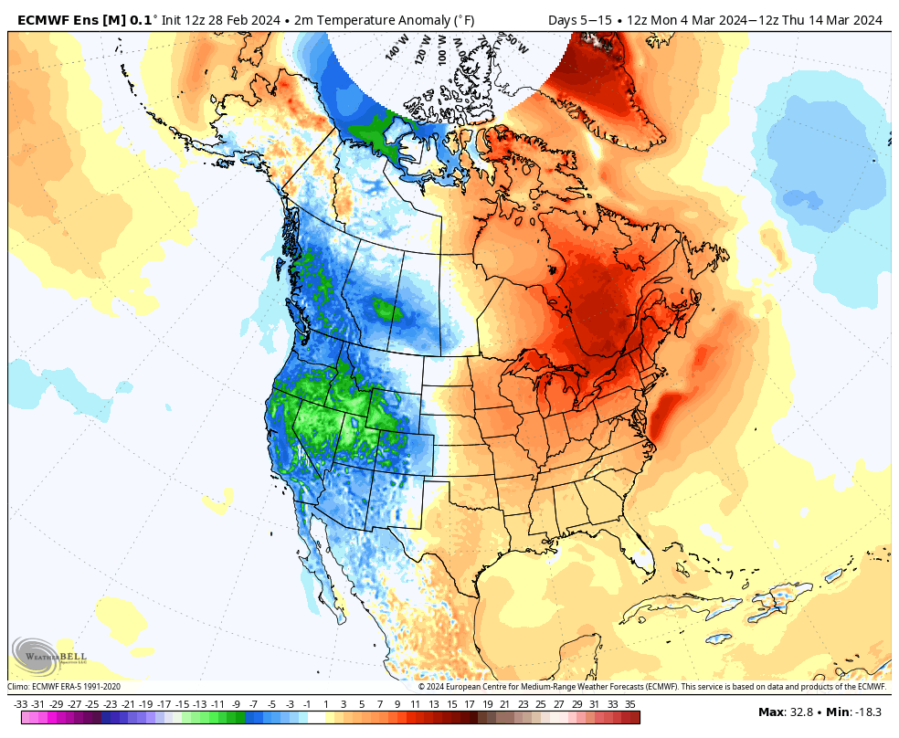
Despite a rather gloomy and seasonally chilly Friday, the remainder of the upcoming 7-day period will feature nothing but unseasonably warm conditions. We’re set to open meteorological spring like we closed out meteorological winter: well above normal in the temperature department.
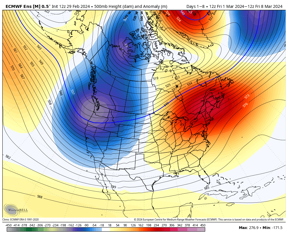
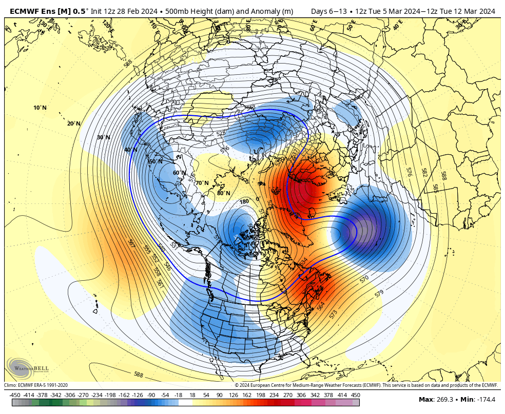
After a perfect weekend (at least by early-March standards), we’ll see periods of unsettled weather as an anomalous upper air pattern remains locked in. Note the deep western trough and expansive, strong eastern ridge.
We’ll push 60° Saturday, 70° Sunday, and zip well into the 70s Monday. (Monday’s record is 78°, set back in 1983, just in case you were wondering).
Dry conditions should remain until we get to Monday night and Tuesday morning.
It’s all the start of an unsettled pattern. An upper low will lift north into the OHV Wednesday with additional showers, followed by a new cold front and associated surface low set to impact our neck of the woods mid and late week.
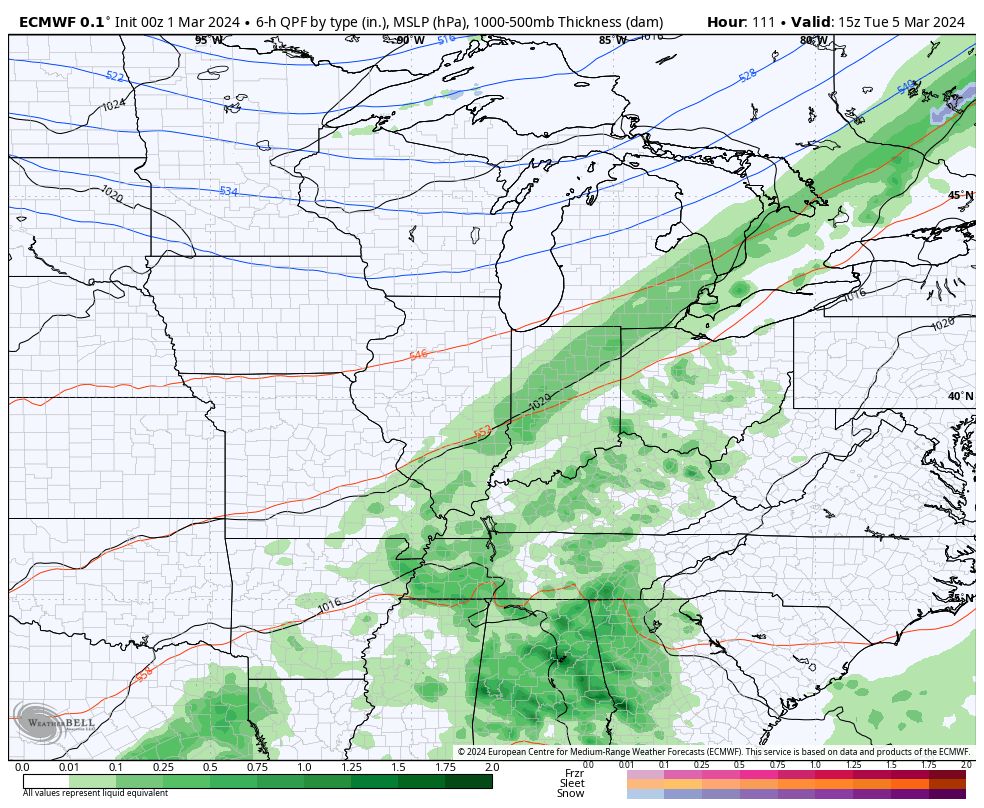
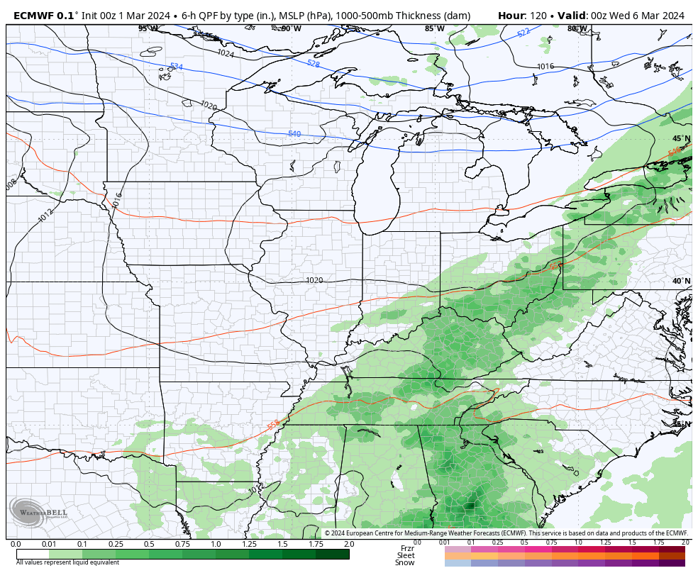
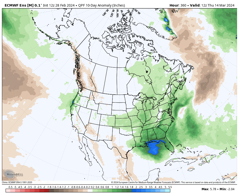
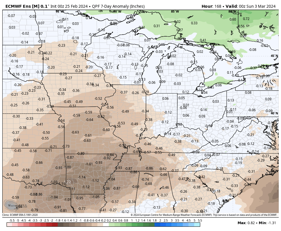
By the time we get to next weekend, widespread 1”+ rain totals can be expected from a combination of the systems.
Tomorrow we’ll welcome in meteorological spring and the first couple weeks of March appear to continue the unseasonably warm trend. At times, additional warm records will likely fall.
A ‘mean’ eastern ridge (and strong western trough) will dominate the 1st half of March.Well above average temperatures are expected through the 1st half of March.
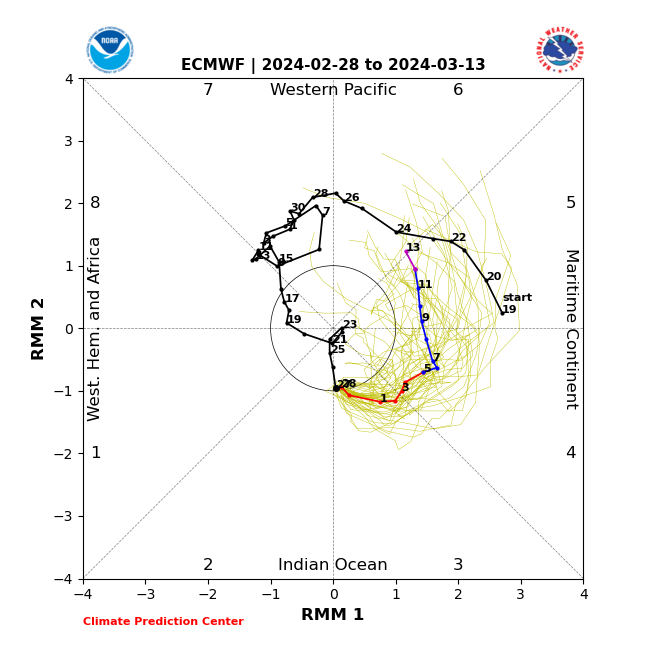
This is strongly correlated with the Madden-Julian Oscillation highly amplified in the classic warm phases this time of year. (You can absolutely say goodbye to any sort of sustained cold prospects this time of year with the MJO in phases 4, 5, and especially 6). Now, down the road, we’ll want to watch and see if we can maintain this amplitude and rumble into the transitional colder Phase 7 before a potential opportunity to see cold grow more impressive should we *finally get into Phase 8 late month. Remember that we made an attempt at that back in mid-February before things instead collapsed into the neutral phase. Moral of the story for folks longing for one more bout of sustained cold prior to the warmer months ahead, “don’t hold your breath.” The trend certainly isn’t your friend.
Back to the present. No matter what the teleconnections say, an amplified MJO will always win out. And the current MJO forecast to roll through the phases listed above screams that our recent warm times will “keep on keepin’ on” as we navigate the 1st half of March.
MJO forecast through March 13th
The Phase 5 and Phase 6 composite analogs at 500mb (upper air pattern) for an El Niño March:
What this should also result in is an active first half of the month, including above normal rainfall and likely at least another early season strong to severe weather event before we get to mid month.
It’s a classic pattern that should feature low pressure systems ejecting out of the Southwest and South-central into the Plains and western Great Lakes region. That puts our neck of the woods on the warm/ wet (and at times stormy) side of the equation.
As we move into late-March and early April, we’ll have our eyes focused on the MJO and whether or not we can, indeed, get into those traditionally colder phases. Stay tuned.
Updated 02.28.24 @ 7:44a Today will serve as a reminder we are still in winter, after all, but another quick warm-up will get underway as we head through the weekend…
You must be logged in to view this content. Click Here to become a member of IndyWX.com for full access. Already a member of IndyWx.com All-Access? Log-in here.
Though a bit earlier than usual this year, it’s time to “dust off” our dedicated weekly post aimed solely at looking at the potential of severe weather in the week ahead. You can expect this to be posted each Sunday morning moving forward through the spring and summer before sunsetting for another year come late September.
An anomalous pattern will dominate the period as we close February and open March. The eastern ridge will become stronger in response to a digging trough across the Western CONUS.
Well above average temperatures can be expected for the Plains and Eastern CONUS through the upcoming week. Cooling behind our midweek frontal passage will be brief before another significant warm-up late week.
The upcoming 2-week period should yield above average precipitation to the majority of the forecast area (to well above average across the Southeast).
Forecast period: 02.25.24 through 03.03.24
The “headliner” system in the forecast period is an area of low pressure tracking into the Great Lakes region Tuesday into Wednesday (02.27 and 02.28). This will drag a trailing cold front through the Ohio Valley Wednesday morning into the afternoon (west to east).
The Storm Prediction Center includes most of the region in some sort of risk of severe weather Tuesday. The greatest risk of severe appears to include an area north and west of a rough line from Evansville northeast to Bloomington and Toledo, OH. While all modes of severe weather are in play, we remain most concerned for the threat of damaging straight line winds Tuesday PM.
Ingredients aren’t off the charts (rarely are this time of year), but parameters are sufficient enough to warrant the chance of strong to severe storms Tuesday into very early Wednesday morning before the cold front moves through the region and results in falling temperatures and a much more stable airmass engulfing the entire OHV through the day. Stay tuned as we continue to fine tune specific timing of storms.
Beyond this point, an area of high pressure will settle overhead, resulting in a much more stable pattern to close the week and head through the weekend. Expect sunshine to return and another quick warm-up to get underway during this period. Highs will zoom back into the 60s next weekend.
Looking ahead, we’ll need to monitor the threat of another potential strong-severe storm window during the early to middle stages of next week. Far too early for specifics, but similar ingredients appear in play which isn’t shocking given the ‘mean’ upper air pattern shown to open this post. We also want to reiterate the above to well above average precipitation expected throughout meteorological spring. Image 3 above highlights the wet look over the upcoming couple weeks.
Updated 02.24.24 @ 8a Any lingering light snow showers will quickly come to an end this morning and we’ll welcome sunshine back into the picture later today. Sunday will feature…
You must be logged in to view this content. Click Here to become a member of IndyWX.com for full access. Already a member of IndyWx.com All-Access? Log-in here.