Updated 02.05.24 @ 6p Potential is on the increase for a period of notable cold during late-February. We look into this along with the staying power, and early thoughts on…
You must be logged in to view this content. Click Here to become a member of IndyWX.com for full access. Already a member of IndyWx.com All-Access? Log-in here.
You must be logged in to view this content. Click Here to become a member of IndyWX.com for full access. Already a member of IndyWx.com All-Access? Log-in here.
First, if you didn’t have a chance to see our thoughts after the European Weeklies came in, you can check that out here.
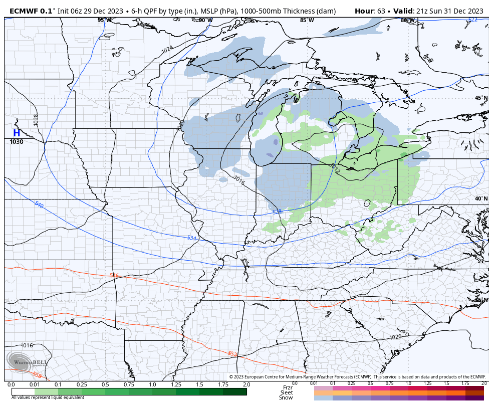
After the snow across portions of western and southern Indiana the past couple days (thank you for all of the reports, by the way), the next feature we’re tracking has to do with a clipper system that will dive southeast across the upper Mid West and into the Ohio Valley New Year’s Eve. This will certainly be moisture-starved, but should have just enough to work with to generate snow flurries and scattered snow showers by late Sunday morning, continuing in off an on fashion into the afternoon and evening.
A weak clipper system will offer up a few snow showers New Year’s Eve.
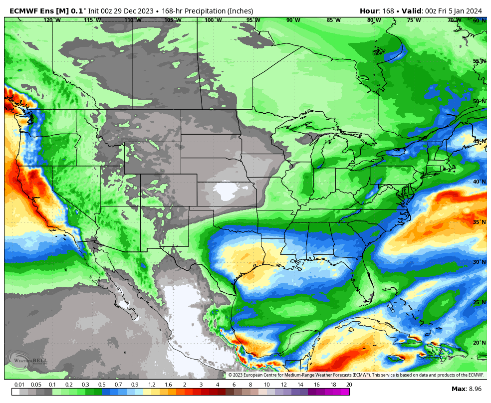
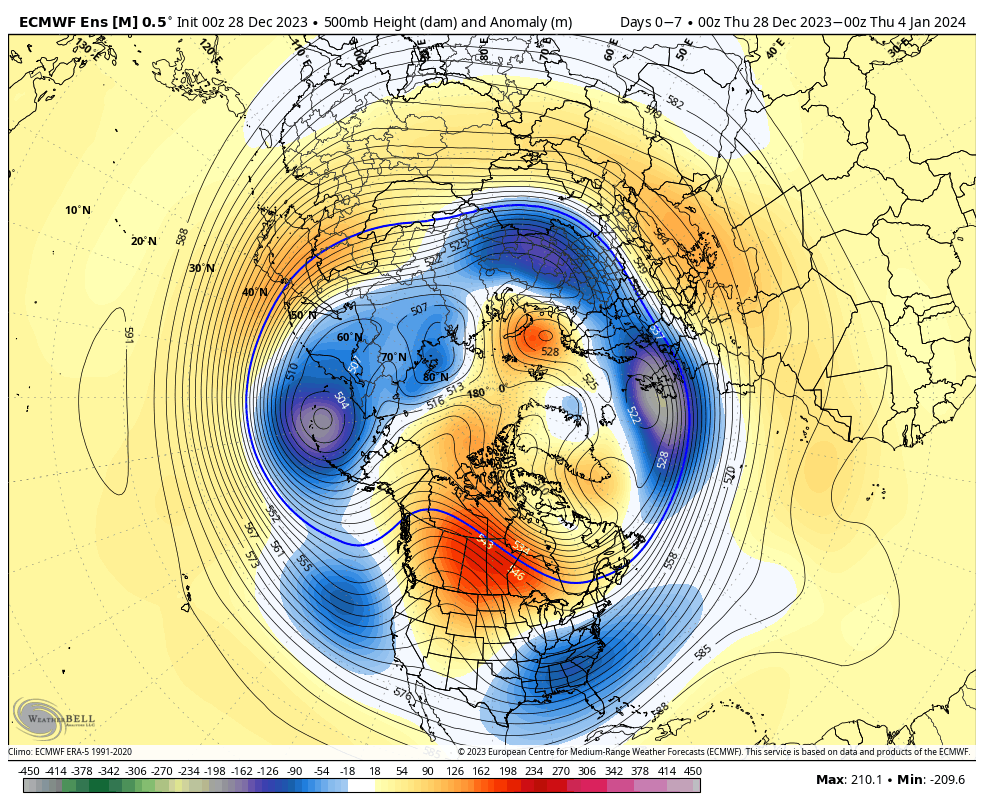
That’s really all there is to track, locally, over the upcoming 7-day period. The predominant storm track will shift off to the south during this time frame as an active, El Niño induced, southern jet takes hold. The one potential feature of interest is out towards the end of next week. We’ll keep an eye on it, but as of now, it looks like the phasing of energy will take place just a little too far east for anything of “excitement” here.
Temperatures will continue to cool closer to seasonal averages and perhaps a bit below normal over the upcoming 10-14 days. Greatest cool anomalies will be located across the western and southern tier during this timeframe.
Updated with European Weekly thoughts 12/29/23 @ 7:09a
There’s no reason to change any of our thoughts concerning how things play out over the next 24 hours with our upper level low pressure system. That idea from yesterday is available here. In short, it still appears as if parts of west-central Indiana are still greatest at risk of seeing light wet snow accumulation (of course some of our friends in southwest Indiana are already enjoying waking up to snow on the ground this morning).
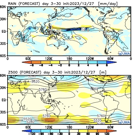
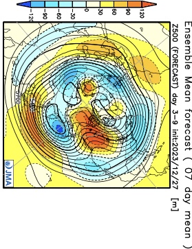
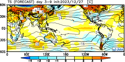
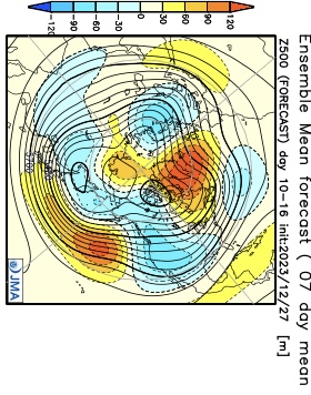
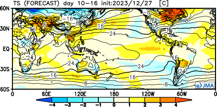
As we look ahead to the upcoming 3-4 weeks (will add to this post later tonight after having a chance to see the updated Euro Weekly teleconnections), it appears as if we’re heading right towards more of a predominant El Niño regime with an active southern storm track and most persistent cold, relative to average, taking up residence across the southern tier. The updated JMA Weekly model portrays this best over the course of the upcoming 28 days:
Modeling continues to struggle with the MJO evolution over the upcoming 2 week period. While this doesn’t impact the idea of colder times in the short-term period, it does have great implications beyond mid-January. The kind of amplitude shown off the American guidance (image 1 below) would threaten to deliver a much warmer than average period, locally, beyond mid-month. Meanwhile, the European (image 2 below) continues to suggest a collapse into the neutral phase.
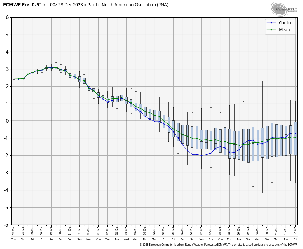
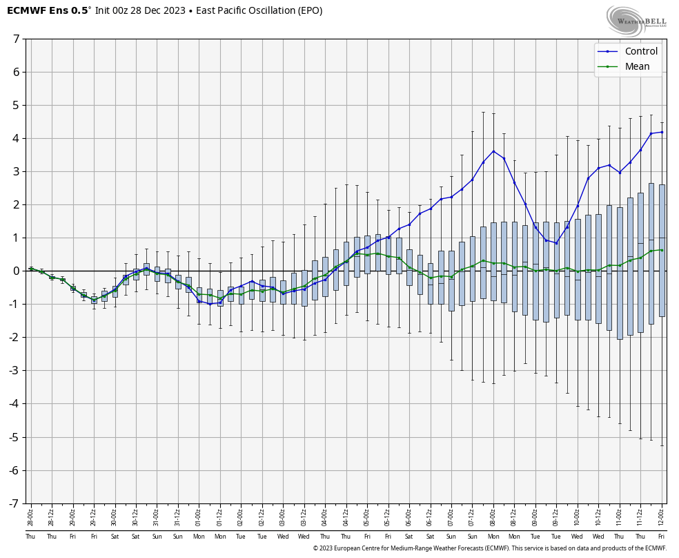
The 2 primary other pattern drivers include the PNA and EPO through mid-January. Beyond this point, we’ll start to incorporate the likes of the NAO and AO into our forecast (hence another reason why we’re interested in seeing how the Euro Weeklies show this later today).
Simply based on how the PNA/ EPO combo is forecast, the first week would open with cooler temperatures transitioning into the region and then we would likely see moderation in the week 2 to early week 3 timeframe.
Week 1
Week 2
While we’re certainly transitioning to a cooler and more active pattern over the upcoming couple weeks, compared to where we’ve been to this point in meteorological winter, it’s not yet to a point where anything looks excessively cold or, for that matter, snowy.
That doesn’t mean that there won’t be a couple storms to track that could offer up some meaningful winter weather potential here, but I just don’t see a sustained cold, snowy pattern taking foot through mid-January. Beyond that point, we’ll have to monitor which more extreme solution plays out. Based on everything going on by that point, it’s still likely to be a situation where either more persistent (and significant) cold or warmth develops.
European Weekly update 12/29/23
The new European Weeklies show a warmer option for the 2nd half of January, but contradict their own teleconnections during this time frame. The model goes to a strong negative AO, positive PNA, negative NAO, and a neutral EPO. Of course we’ll have to see what the MJO ultimately ends up doing but that combo strongly argues for the colder option for the 2nd half of January.
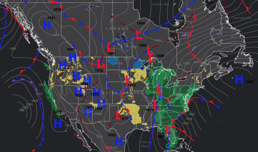
An area of low pressure and associated cold front will continue to move east across the state this morning. Morning showers will come to an end from west to east over the next couple of hours. Speaking of rain, most area rain gauges picked up around half an inch of precipitation overnight. (Thank you for all of your reports)!
Meanwhile, our big coastal low will continue to deepen on its’ journey north along the eastern seaboard over the next 24 hours. Major impacts from high surf, heavy rain, and strong winds can be expected up and down the East Coast, along with significant airport impacts Monday. – Certainly not the start to the pre-Christmas week of travel many may hope for. As colder air pours in on the backside, a heavy, wind-whipped snow event will unfold from the high ground of those beautiful east TN and western NC mountains, up into the interior portions of the Northeast.
Surface Map Sunday Morning
Back here on the home front, we still anticipate a piece of upper level energy to accompany a brief “jab” of arctic air to open up the last work week before Christmas.
This will help snow showers develop Monday morning with some locally intense snow squalls impacting the region late morning through the afternoon. These squalls will be most widespread north and east of the city, itself, but even into Indianapolis, I’d anticipate a couple heavy bursts of snow and briefly reduced visibilities Monday. While a dusting to perhaps as much as a half inch of snow is all we can expect across immediate central Indiana, areas downwind of Lake Michigan (north-central and northeast Indiana, including portions of east-central Indiana) can expect 1″ to 2″ with locally heavier amounts in spots where more persistent lake bands take hold.
While we’re not envisioning any sort of plowable snows locally, the brief more intense squalls will be capable of producing slick spots at times. Plan to allow extra time to safely reach your destination. Snow removal Clients, salting will be required across central and east-central Indiana Monday.
Snow showers and heavier squalls will increase through the day Monday.
Wind will be the other component Monday, along with falling temperatures. We expect northwest gusts to approach 35 MPH at times. Wind chills will fall into the 10s.
Just as quickly as the snow and wind hits Monday, it’ll leave. High pressure will build in overhead Tuesday allowing sunshine to return in full force. After a cold day, temperatures will begin to moderate through midweek.
An increasingly moist, but milder, southwesterly flow will take hold late week which will lead to increasingly cloudy and gloomy conditions with rain returning. Unfortunately from this distance, it still appears that we’ll remain socked in with clouds and rain at times Christmas along with highs in the upper 40s to around 50. Areas of fog can also be expected at times.
Rain will return Thursday night and remain with us periodically through the Christmas holiday.
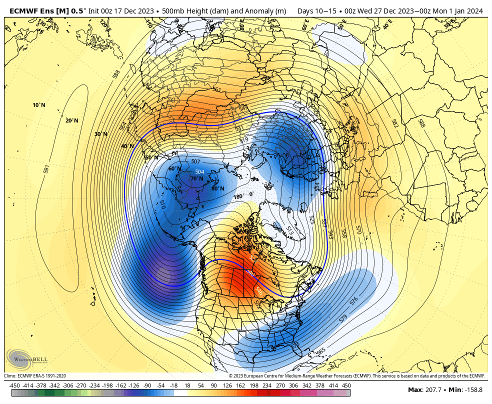
Longer term, all systems are “a go” for a more substantial pattern shift towards colder and potentially wintry fun and games as we close out the year and head deeper into January. Model guidance over the weekend has grown more intriguing with not only the idea of a slower MJO rotation through the classic cold phases, and the EPO is also showing more and more signs of going negative.
While still not ready to say we’re primed for any sort of arctic outbreak, the thought here remains that we go slightly colder than normal early January with an active southern stream of the jet. Based off what the EPO and MJO do beyond this point (along with the AO/ NAO combo come mid-month), and the potential of laying a snowpack down will determine how cold we can go beyond mid-Jan.
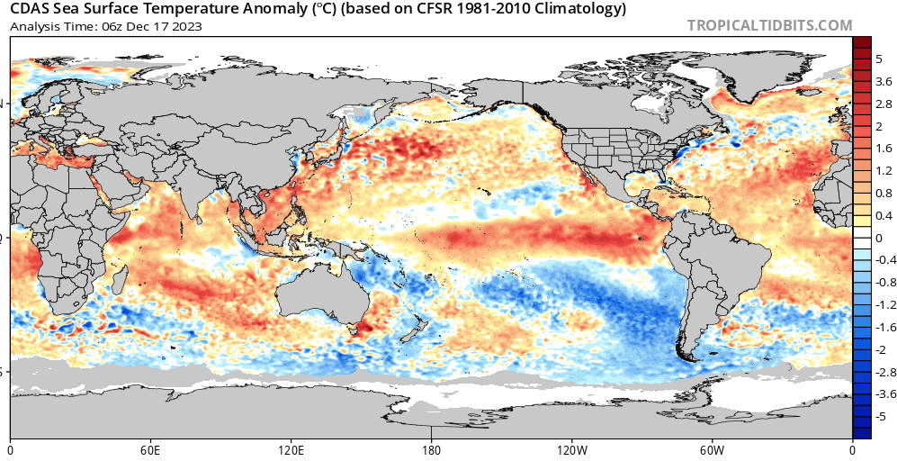
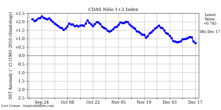
You don’t need us to tell you that our El Nino is alive and kicking. What’s of interest is the cooler trends that continue in earnest in region 1+2. Should this continue, then the plot will thicken late winter and spring for the possibility of continued colder trends. . .