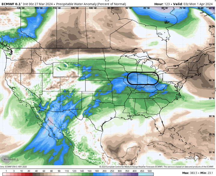
Today is gorgeous. The good news is next Tuesday will also feature gorgeous conditions. Unfortunately, there’s not a lot of gorgeous weather in-between. Modeling continued to trend wetter overnight and it’s becoming increasingly likely that portions of our area will have to deal with flooding once again by early next week as a result…
Updated 04.15.25 @ 7:39a Seasonably cool conditions will be with us through our Tuesday with a few showers developing (most numerous north-central and east-central parts of the state) late morning…
You must be logged in to view this content. Click Here to become a member of IndyWX.com for full access. Already a member of IndyWx.com All-Access? Log-in here.
Updated 04.13.25 @ 8:52a We’ll close the weekend out with quiet and pleasantly mild conditions. A weak, moisture-starved system will scoot through the Ohio Valley to open the work week,…
You must be logged in to view this content. Click Here to become a member of IndyWX.com for full access. Already a member of IndyWx.com All-Access? Log-in here.
High pressure will build overhead and allow increasing sunshine through midweek. Enjoy that Vitamin D while you can, as a wet pattern emerges for the Easter weekend and into early next week. Multiple rounds of heavy rain may eventually lead to a flood risk by early next week.
Permanent link to this article: https://indywx.com/video-briefly-calmer-pattern-midweek-takes-on-a-wet-unsettled-look-over-the-easter-weekend-and-early-next-week/
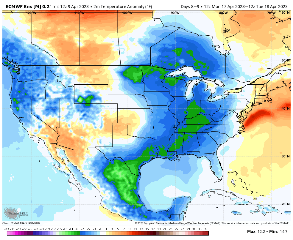
First and foremost, here’s wishing you and your family a very happy and blessed Easter Sunday! The week ahead doesn’t offer up much “excitement” in the weather department, but that comes to a screeching halt early week 2 as a potent storm system finally delivers a return of precipitation, and perhaps more notably, an unseasonably cold “jab” of air!
In the short-term, high pressure will dominate the upcoming work week, including a “rinse and repeat” regime of sunny days along with moderating temperatures.
Highs will climb into the mid to upper 70s by the 2nd half of the work week. Dry conditions will prevail.
It’s not until this weekend when unsettled weather will return to central Indiana and the Ohio Valley as a whole. This is all thanks to a cold front and associated area of low pressure.
Though early, model consensus shows a “cut off” low developing early next week, keeping unsettled conditions in play. It’s not just the likelihood of lingering precipitation, but a significant push of late season chilly air is also dialed up to plunge into the region. In fact, it wouldn’t be surprising to see the air grow cold enough where rain showers may mix with and change to wet snow showers.
Regardless if we’re talking snow or not, highs in the 40s with lows in the 20s will be a bitter pill to swallow after the extended stretch of pleasant (and increasingly warm) weather we’ll continue enjoying through the week…
We’re targeting early next week for a “jab” of unseasonably cold air.
Needless to say, this system will be a topic of discussion through the upcoming week. More in our Client video discussion Monday morning!