You must be logged in to view this content. Click Here to become a member of IndyWX.com for full access. Already a member of IndyWx.com All-Access? Log-in here.
Category: Client
Permanent link to this article: https://indywx.com/2019/03/24/sunday-evening-video-update-heavy-rain-strong-storms-expected-for-southern-in-tonight/
Mar 24
Heavy Rain, Couple Strong Storms Possible Across Southern IN Tonight…
Scattered showers will spread across central Indiana at times through the day. Most of this rain will be light in nature through the afternoon hours, but a couple of moderate showers are also possible.
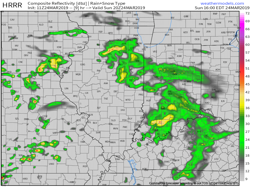
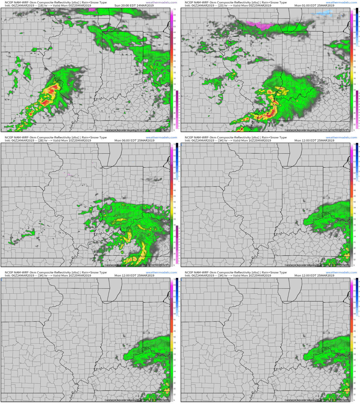
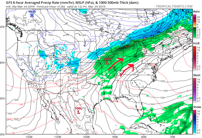
A surface low will track east across the lower Ohio Valley tonight and this will result in more concentrated heavy rain falling across the southern portion of the state this evening into early Monday morning. This is a bit further south than model guidance suggested yesterday. Additionally, a couple of strong thunderstorms are also possible tonight across far southern Indiana.
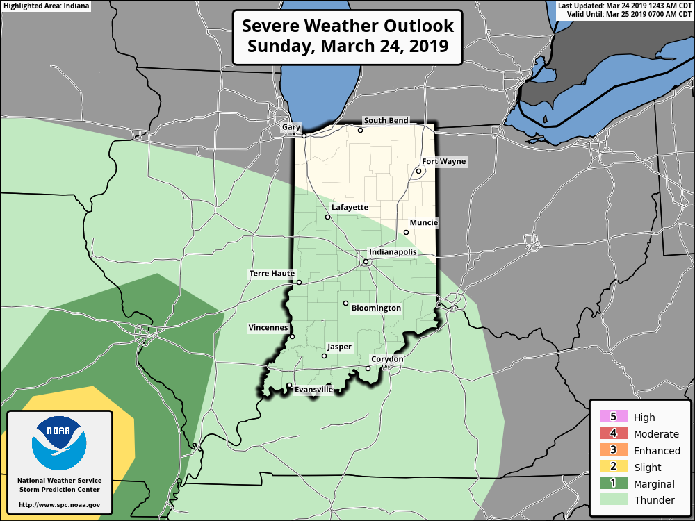
It wouldn’t surprise us to see the Storm Prediction Center (SPC) include portions of southern Indiana in a ‘Marginal’ or ‘Slight’ risk of severe weather tonight with future updates.
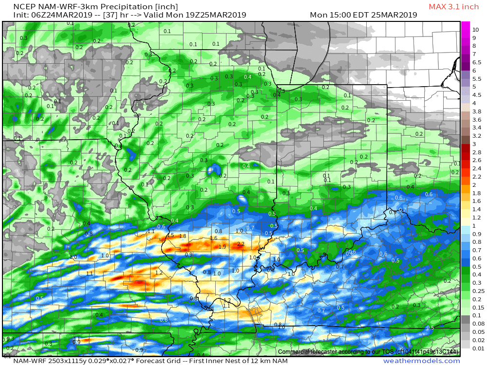
With the more southern track now expected from this storm system, the corridor of .50″ to 1″ rainfall totals will settle across the southern portions of Indiana, with 0.10″ to 0.25″ expected for central Indiana on average.
Rain will come to an end for all of the state by mid to late morning Monday with dry conditions returning Monday evening into the middle of the week, thanks to high pressure.
Dry and pleasant conditions will remain in place through the daytime hours Thursday before a storm system approaches Thursday night into Friday. The gusty southwesterly air flow in advance of this storm will help pull warmer conditions northeast into the Ohio Valley. Highs between 65-70 are on tap by Thursday afternoon. Unsettled weather is anticipated to remain through next weekend along with progressively colder conditions.
Permanent link to this article: https://indywx.com/2019/03/24/heavy-rain-couple-strong-storms-possible-across-southern-in-tonight/
Mar 23
Spring Flood Outlook…
It’s been since 2013 since the Lower 48 has seen greater snow cover on the 23rd of March.

Officially, 25.4% of the Lower 48 is currently snow covered, including crucial areas that feed downstream rivers in the north-central Plains and upper Midwest.
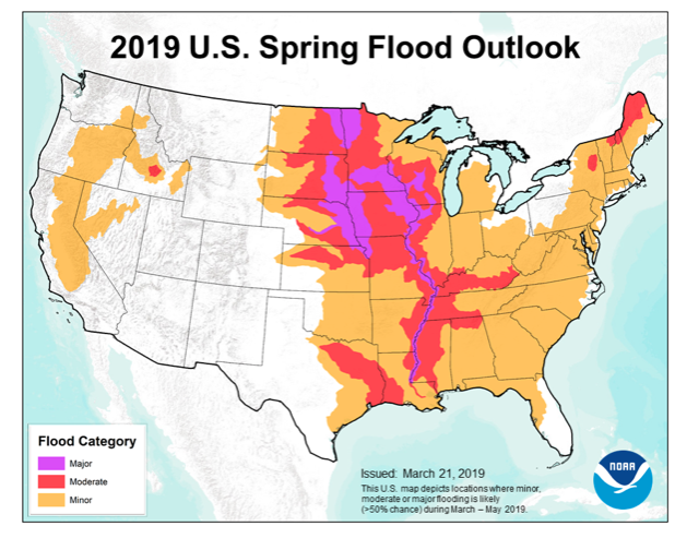
NOAA released their Spring Flood Outlook Friday. This shows major to moderate flooding expected on area rivers from the northern Plains south along the MS River. Even moderate to minor river flooding is anticipated across the east, including the Ohio Valley.
The full report can be found here.
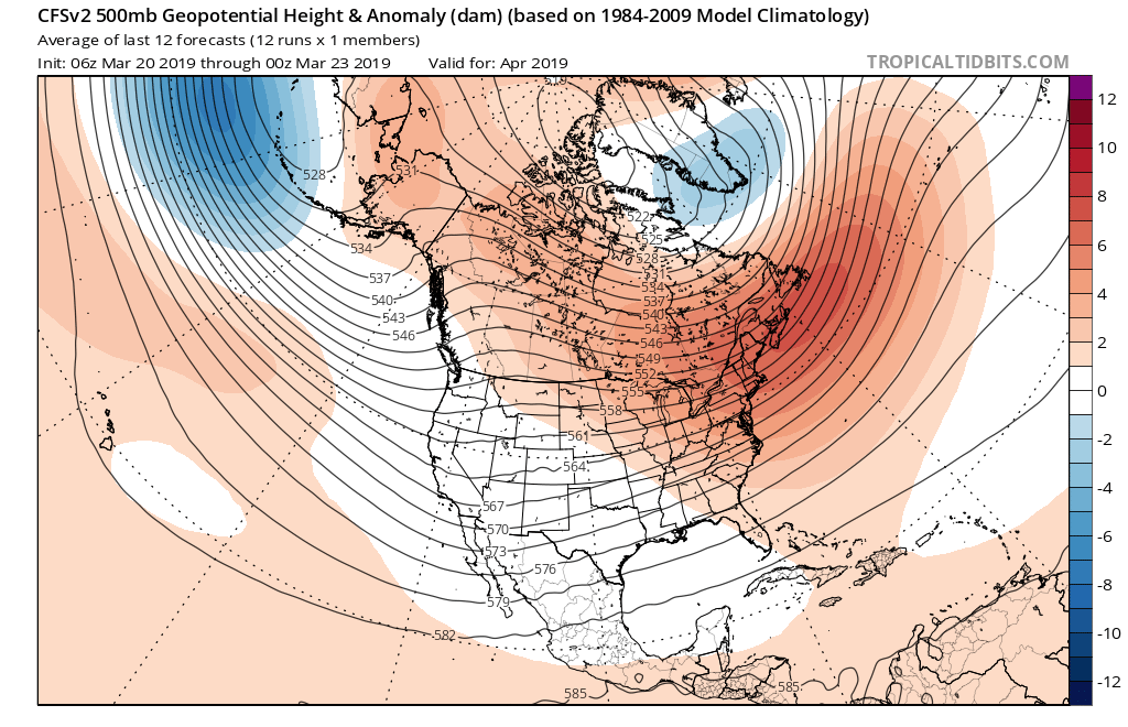
As we move into April, a ridge is expected to back west and result in an active storm track from the west into the Mid West and Great Lakes. The end result will be a favorable pattern for above average precipitation. Factor that in with the above average late season snowpack currently in place across the exact same region, and the stage is set for moderate to significant river flooding through the remainder of the spring.
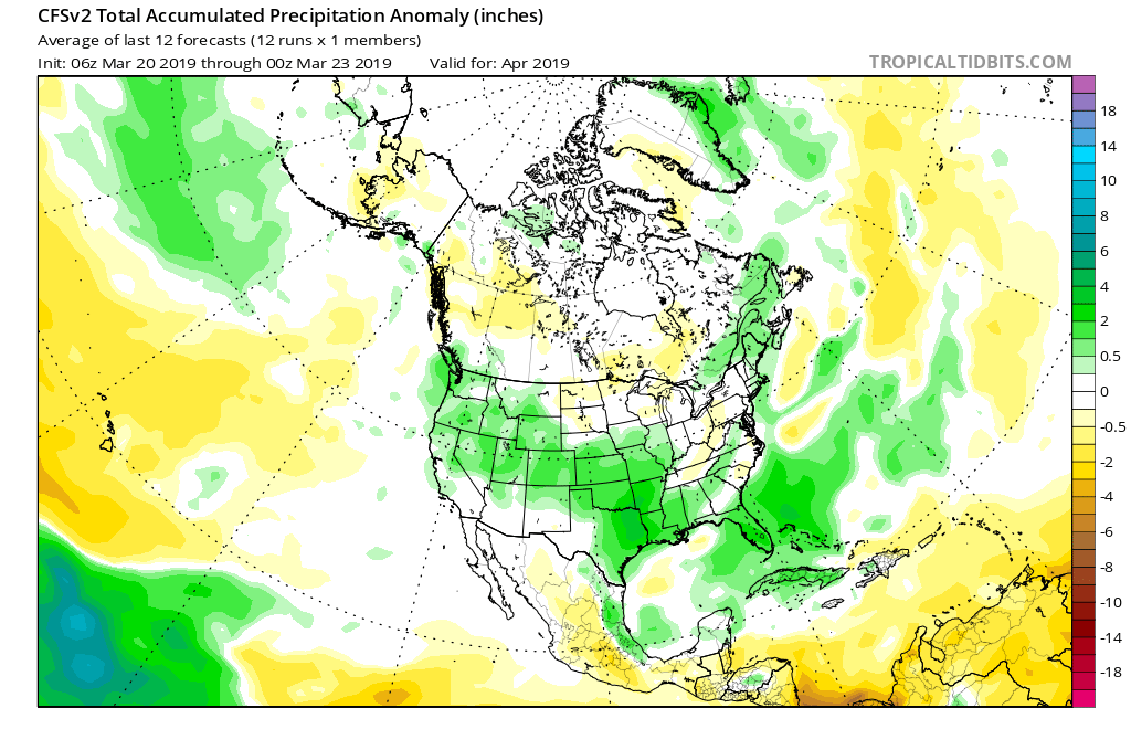
More specific to central Indiana, we also expect an active spring storm track- including precipitation that is around “average” from the March through May (meteorological spring) period. As warmth expands as we move into mid-April, expect an uptick in severe weather episodes further north during the 2nd half of April into May.
Permanent link to this article: https://indywx.com/2019/03/23/spring-flood-outlook/
Mar 23
Gorgeous Saturday; Active Pattern Awaits…
You must be logged in to view this content. Click Here to become a member of IndyWX.com for full access. Already a member of IndyWx.com All-Access? Log-in here.
Permanent link to this article: https://indywx.com/2019/03/23/gorgeous-saturday-active-pattern-awaits/
Mar 22
Timing Arrival Of Our Late Month Storm Systems…
A beautiful open to the weekend awaits and while we’re currently enjoying calmer times, we wanted to go ahead and time out the arrival of storm systems as we move through next week and the end of March.
Sunday, 3.24.19 into Monday, 3.25.19
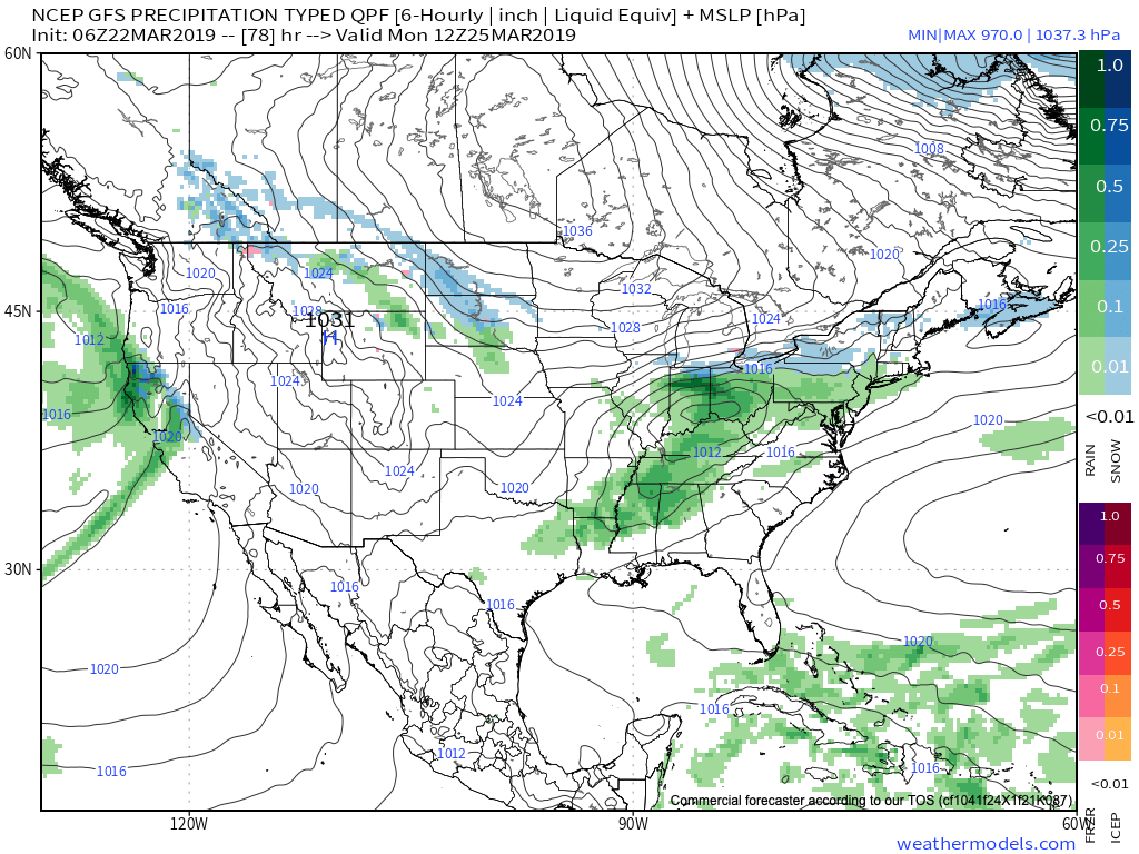
Clouds will increase Saturday night and precipitation will follow Sunday in the form of light rain that will continue into Monday. As colder air presses south, rain may mix with or change to light snow across northern areas before ending, but this doesn’t appear to be a major deal (more of a nuisance than anything else). Rainfall totals around half an inch on average can be expected with this system before drier air arrives (and sunshine) Tuesday.
Thursday, 3.28.19 into Saturday, 3.30.19
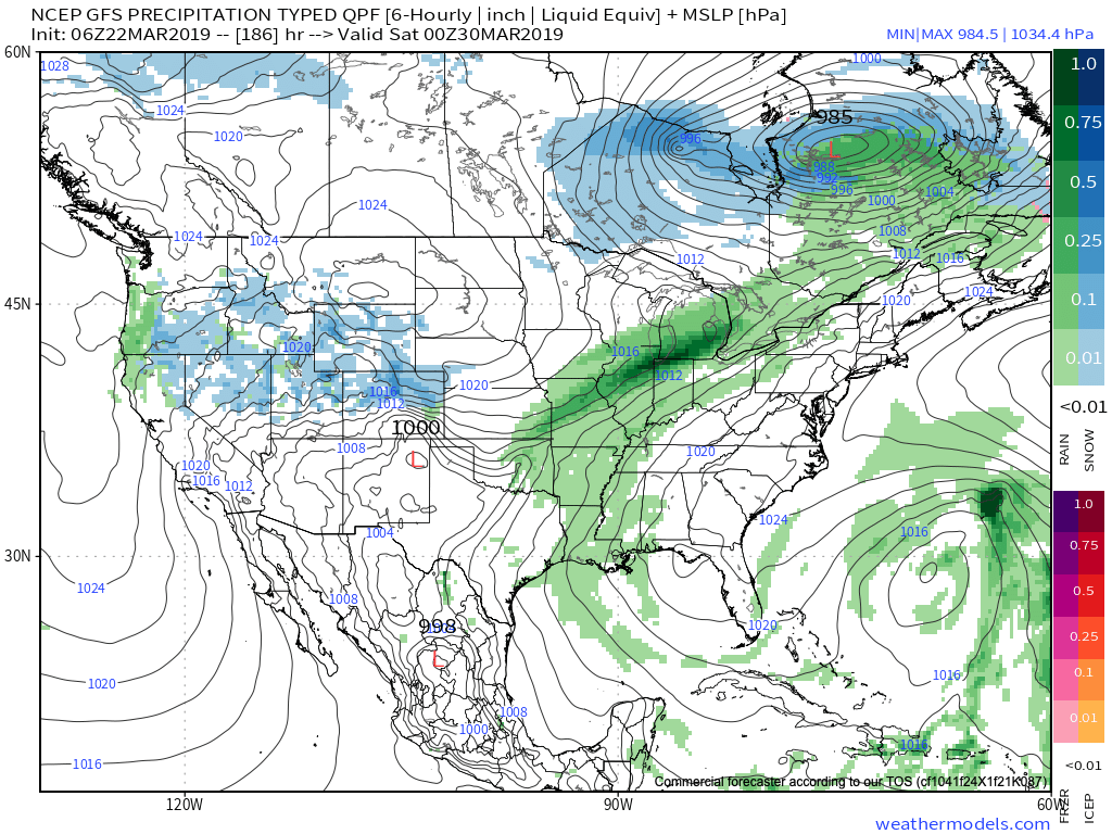
After a drier stretch of weather the middle of next week, rain will return Thursday evening into early next weekend. There are differences with the way models handle the frontal passage next weekend (couple of solutions stall the front to our south and bring another wave of moisture up along the boundary that would potentially lead to renewed wet conditions next Sunday into next Monday). The early call here is that this system will have more moisture to work with than it’s predecessor.
Yet another storm system will approach the middle parts of Week 2.
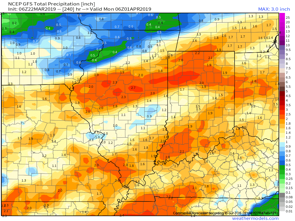
Current projected rainfall totals off of the latest GFS forecast model look decent from this distance over the upcoming (10) days.
Permanent link to this article: https://indywx.com/2019/03/22/timing-arrival-of-our-late-month-storm-systems/
Mar 22
Friday Morning All-Access Video: Pattern Turns More Active Next Week…
You must be logged in to view this content. Click Here to become a member of IndyWX.com for full access. Already a member of IndyWx.com All-Access? Log-in here.
Permanent link to this article: https://indywx.com/2019/03/22/friday-morning-all-access-video-pattern-turns-more-active-next-week/
Mar 21
More On The Late March-Early April Pattern And Reviewing The NEW JMA Weeklies…
As we look ahead, a persistent western Canada/ Alaska ridge continues to show up on the medium to long range data. The downstream implications are for cooler than normal temperatures, overall, across the eastern and central portions of the country into early April.
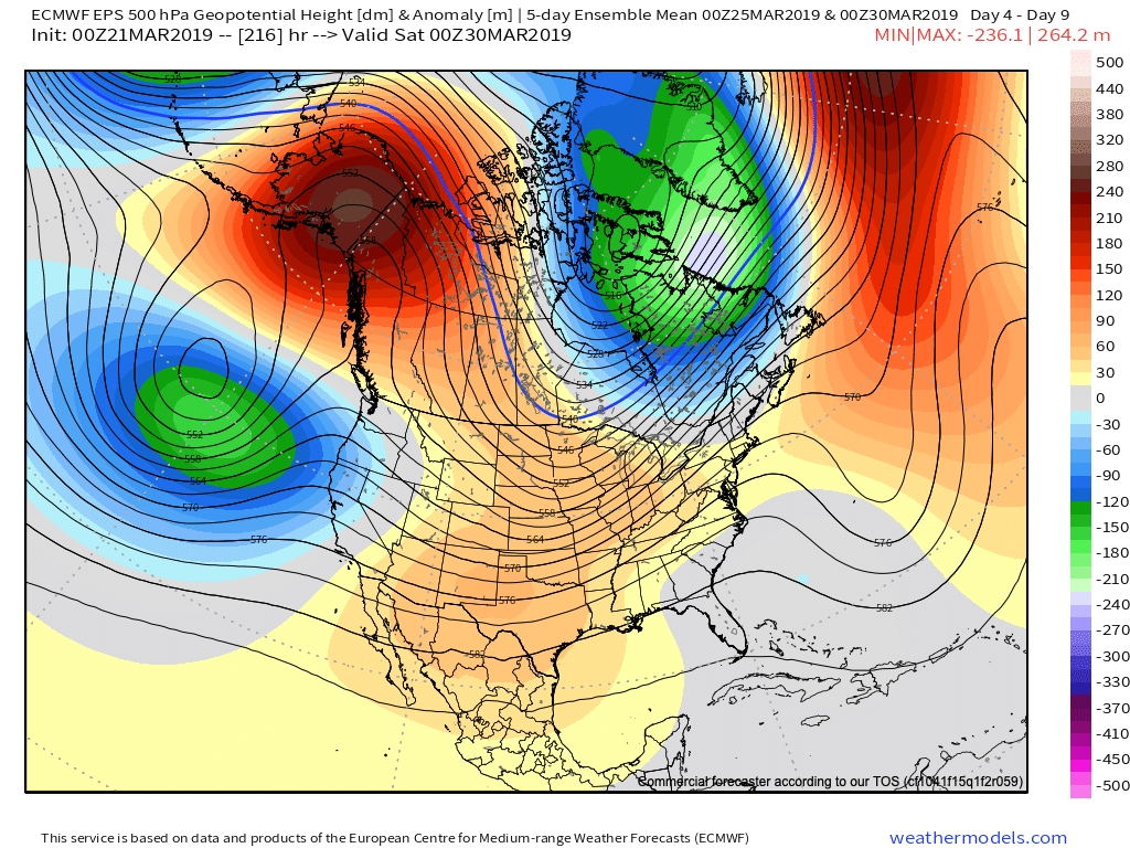
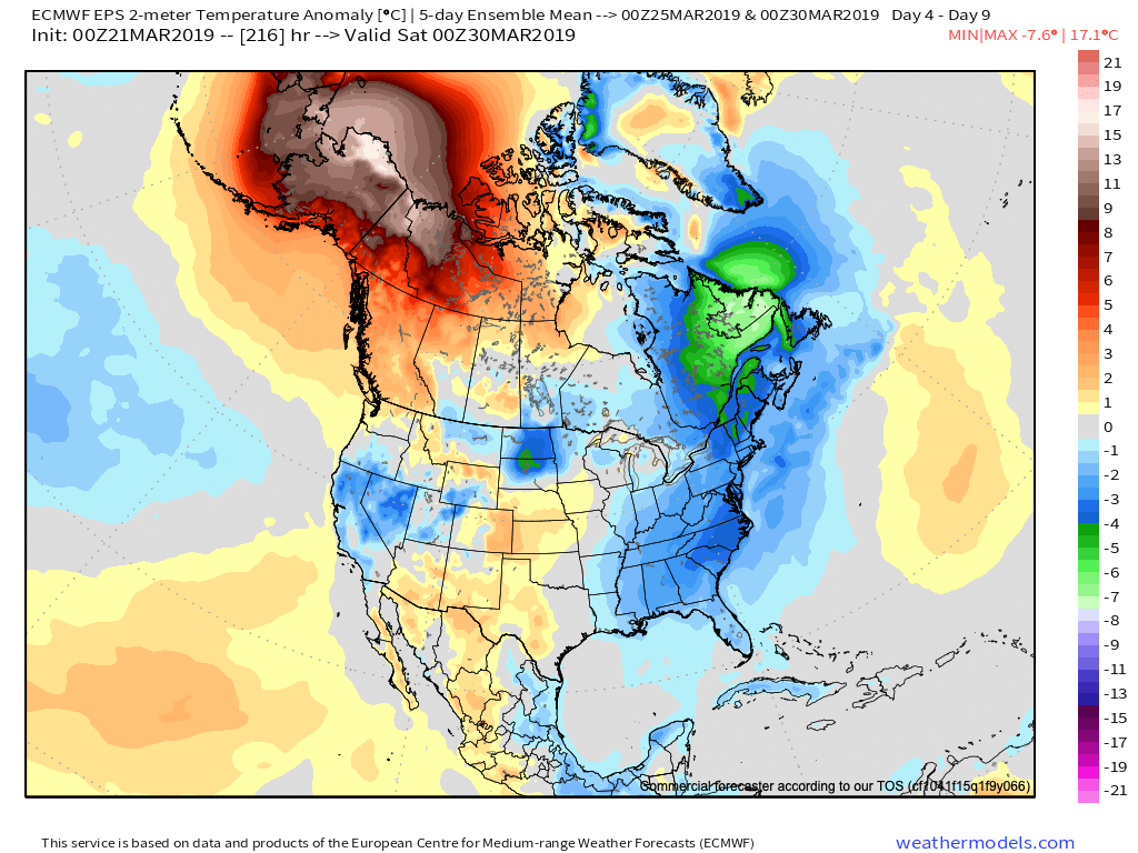
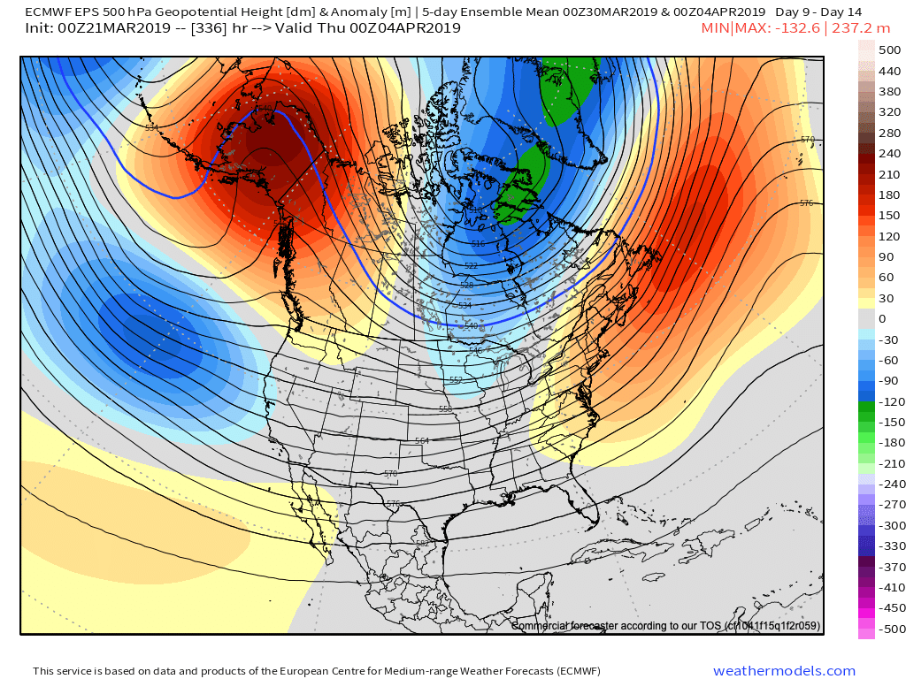
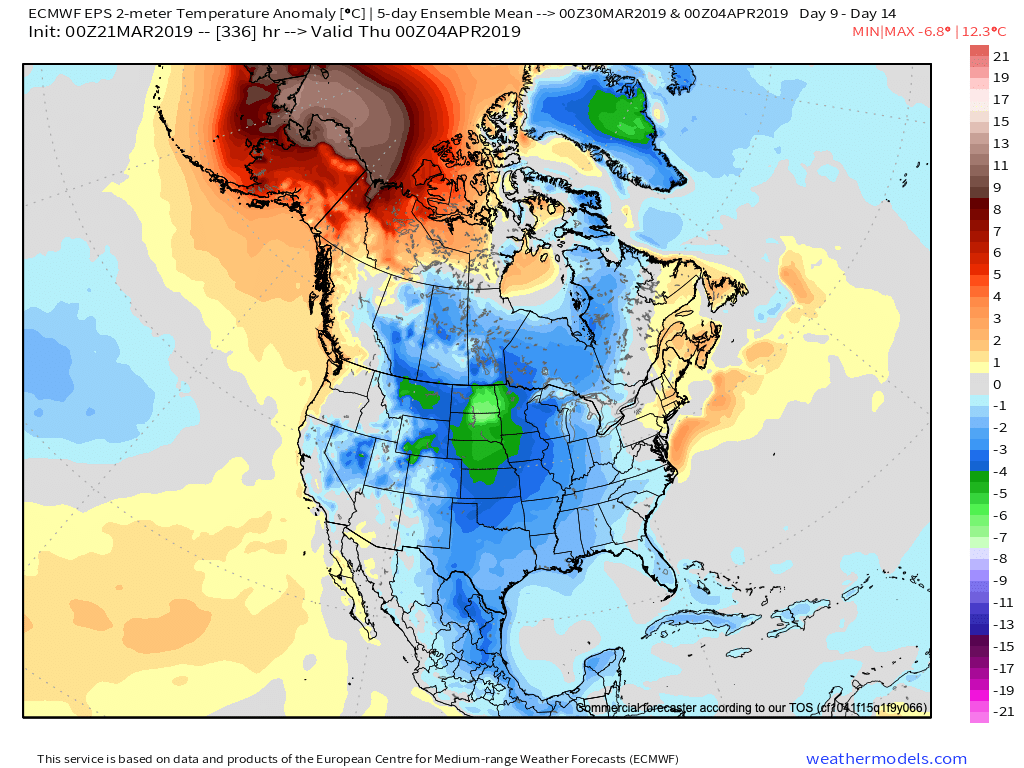
Given the time of the year (and pattern), cool won’t rule the entire period. It’s just that the cold will “out do” the transient warmth in between storm systems over the next couple of weeks.
When we look at the teleconnections (combo of negative EPO and neutral to slightly positive PNA is ruling the day for now), they support the lingering chill into early-April.


However, as we turn the page from early-April to mid-April, the idea here is that an eastern ridge will begin to expand west with more “umph” and eventually lead to warmth overwhelming the pattern. We aren’t budging from the original idea of a warmer than normal April by month’s end. It sure appears as if the NEW JMA Weeklies are catching onto this idea.

From a precipitation perspective, the majority of medium and long range model data does show a return of wetter times (relative to normal) as we move into April, including an active storm track. The beginning of this overall shift in the pattern back towards wetter than normal conditions will begin early next week.


We’ll recap our latest short-term thinking, including an update on the NEW European Weeklies that will arrive this evening later tonight in a video update.
In the meantime, make it a fantastic Thursday- and happy tip off to March Madness!
Permanent link to this article: https://indywx.com/2019/03/21/more-on-the-late-march-early-april-pattern-and-reviewing-the-new-jma-weeklies/
Mar 20
All-Access Video: Showers Arrive Later Today; Still Expecting A Beautiful Weekend And Looking Ahead To More Active Times…
A weak system will spread showers across central Indiana later today. We take a look at timing and amounts, along with spending time going over the long range pattern into…
You must be logged in to view this content. Click Here to become a member of IndyWX.com for full access. Already a member of IndyWx.com All-Access? Log-in here.
Permanent link to this article: https://indywx.com/2019/03/20/all-access-video-showers-arrive-later-today-still-expecting-a-beautiful-weekend-and-looking-ahead-to-more-active-times/
Mar 19
Disruption In The Force…
There are growing indications the once thought warm flip in the pattern will be delayed. While “seasonality” is helping us certainly improve in the temperature department from the frigid open to March, data is trending (and some dramatically so) colder for late March and early April.
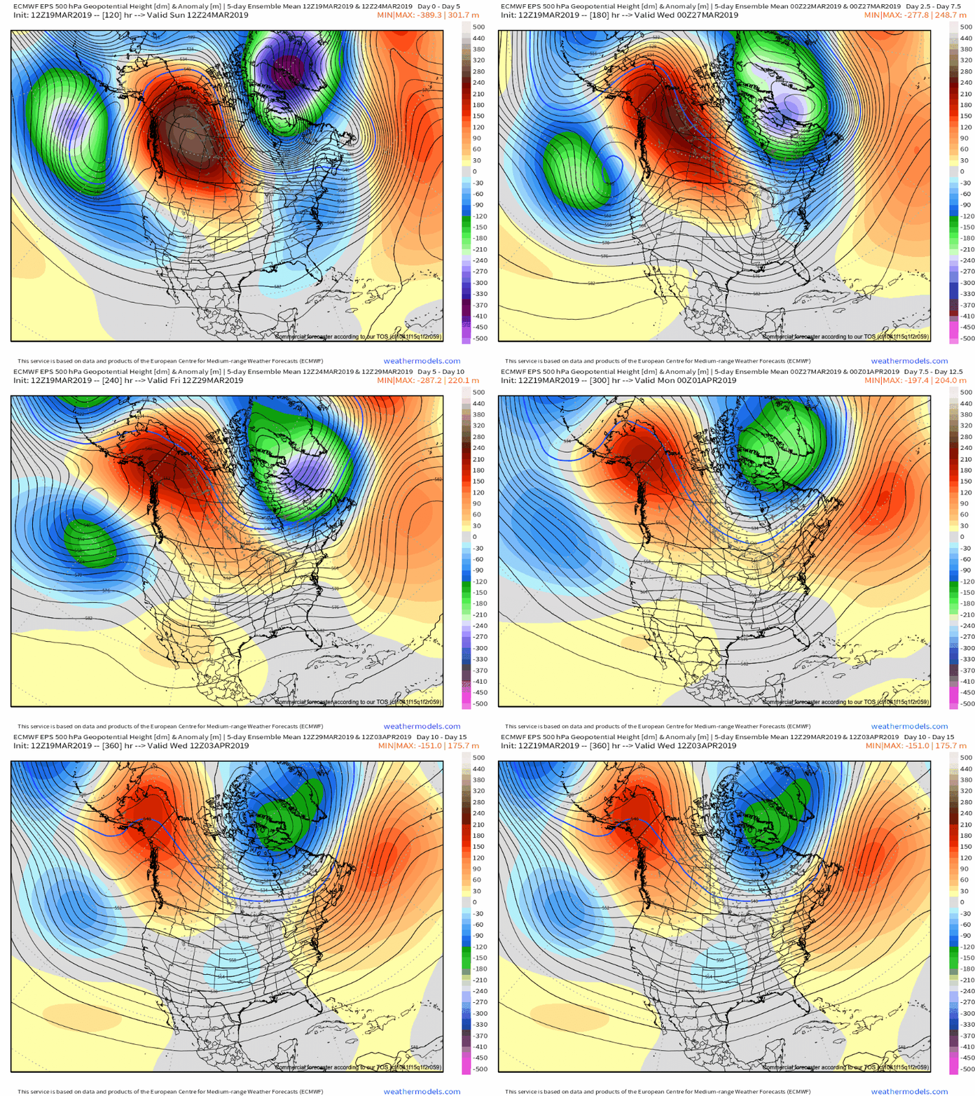
Part of this can be attributed to the persistent AK ridge and positive PNA/ negative EPO pattern in place. Without question, medium and long range modeling as early as less than a week ago missed this. Note the above image and tendency for prolonged ridging across AK into early April. This will favor cooler anomalies downstream, including here across central Indiana. That’s not to say there won’t be multiple warm and pleasant days thrown in the mix (it’s late March, after all), but instead to say that the pattern overall looks much cooler when compared to what the majority of data was painting only a handful of days ago.
Embedded within this pattern will come a return of active times, including multiple storm systems of note over the upcoming 10-14 days. The flavor of said systems will change from originally thought as hefty rain and potential severe events to rain and perhaps some wintry precipitation. With that said, specifics are impossibly to come by in this “chaotic” pattern and we suggest staying tuned as we get closer to the arrival of the first system early next week.
Like your weather pattern “interesting?” You’re in luck over the upcoming couple of weeks…
Permanent link to this article: https://indywx.com/2019/03/19/disruption-in-the-force/
Mar 19
Tuesday Morning Video: Reason To “Tap The Brakes” On Late Month Warm-Up?
You must be logged in to view this content. Click Here to become a member of IndyWX.com for full access. Already a member of IndyWx.com All-Access? Log-in here.
Permanent link to this article: https://indywx.com/2019/03/19/tuesday-morning-video-reason-to-tap-the-breaks-on-late-month-warm-up/
