Category: Client

Tuesday Afternoon Rambles: Weekend Model Differences; What’s Beyond The Cooler Mid-May Shift?

I. A couple widely scattered light showers have flared up this afternoon, but most central Indiana neighborhoods have enjoyed dry conditions with sunshine and temperatures in the mid-upper 70s. Look for more of the same Wednesday, including filtered sunshine through a good chunk of the day. Warm Air Advection (WAA) will help boost temperatures into the lower 80s for most of the immediate area.
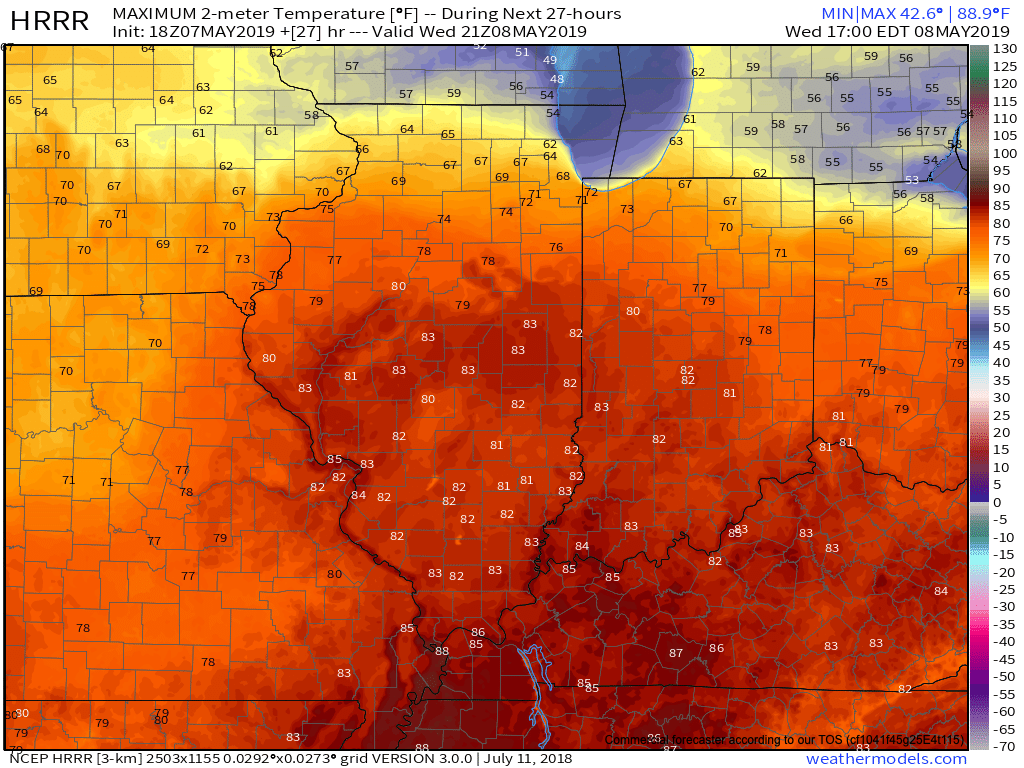
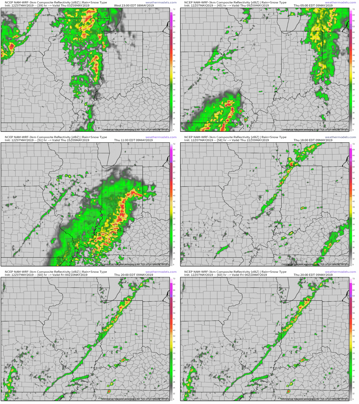
II. Better aerial coverage of showers and thunderstorms will develop late Wednesday night into Thursday night. We believe 3 rounds of showers and storms are possible during this time frame (at least impacting portions of the central Indiana viewing area):

  • Late Wednesday night into the predawn Thursday
  • Thursday afternoon
  • Thursday evening as the cold front sweeps through the state
III. High pressure will build into the region as we close the week. This will lead to improving weather conditions, including increasing sunshine. A very nice close to the work week/ open to the weekend is dialed up! Make those patio plans now!

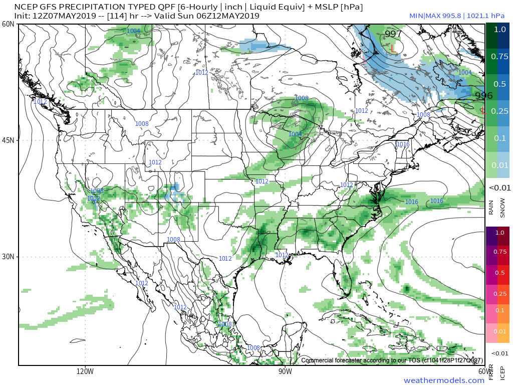
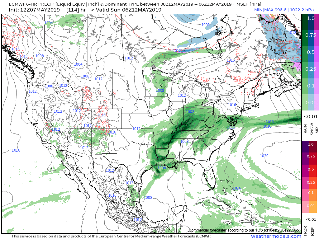
IV. Modeling differs on the handling of our weekend weather feature(s). The GFS (image 1) maintains the idea of a dry Saturday, followed by showers Sunday as a cold front sweeps through the region. Moisture would be limited with such a solution. The European (image 2), however, is more bullish on a more widespread rain event arriving Saturday PM into Sunday AM. Stay tuned as we work to reach some sort of agreement between the data.
V. After a cooler than normal period of weather through the middle of the month, we’re thinking the coolest anomalies will pull back into the intermountain west and 4-Corners region. Do we foresee any major late-May heat? No, but we should moderate against the norms during the last week to 10 days of the month.

After a drier stretch of weather through the mid-May period, precipitation should return to at least average levels through the late month stretch. Early indications would then suggest wetter than normal times return as we get set to open June…

Permanent link to this article: https://indywx.com/2019/05/07/tuesday-afternoon-rambles-weekend-model-differences-whats-beyond-the-cooler-mid-may-shift/

All-Access Video: More Chatter Around The Mid-Late May Pattern…

You must be logged in to view this content. Click Here to become a member of IndyWX.com for full access.  Already a member of IndyWx.com All-Access?  Log-in here.

Permanent link to this article: https://indywx.com/2019/05/07/all-access-video-more-chatter-around-the-mid-late-may-pattern/

More Evidence Behind Mid-May Shift To Cooler And Drier…

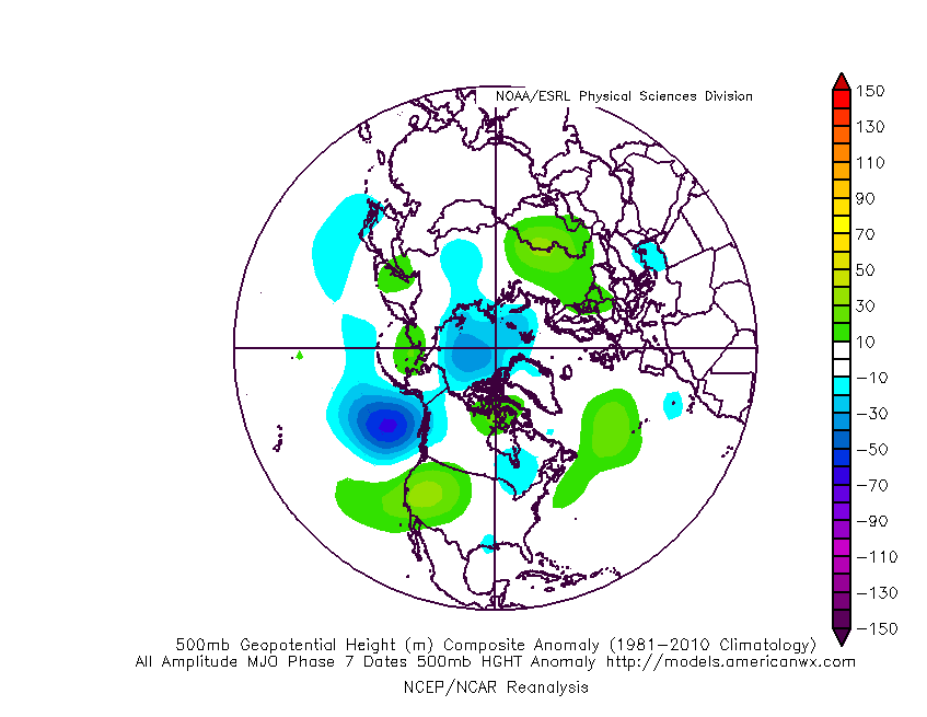
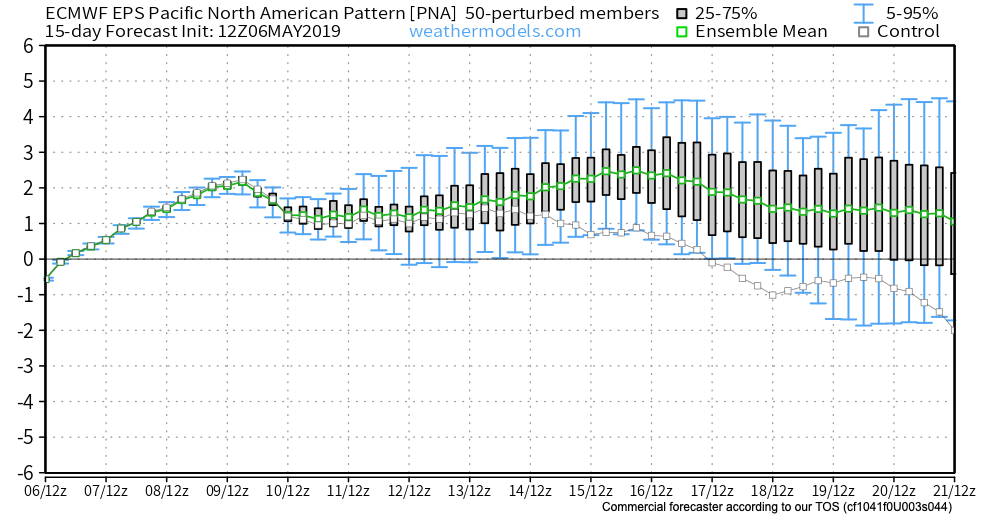
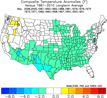
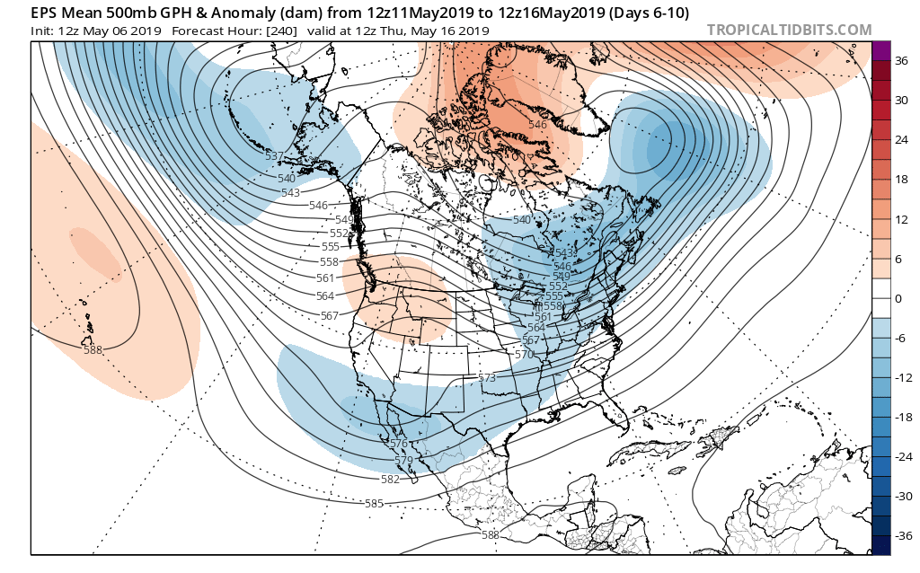
Though May has opened warmer than average (to the tune of 1 degree F above normal, month-to-date), there’s growing evidence behind a shift towards not only a cooler pattern for mid-month, but drier, as well.

MJO:

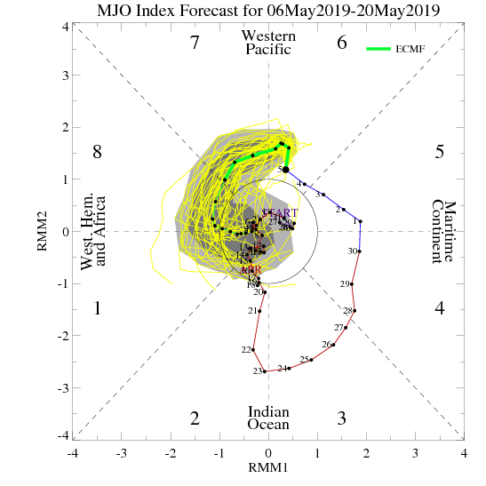
The Madden Julian Oscillation is forecast to move through Phase 7 (a cooler phase in May across the eastern half of the country).

PNA:

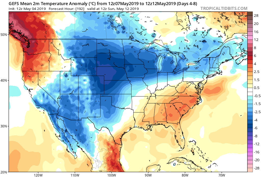
The Pacific North America pattern is forecast to remain positive into mid-May. This favors a cooler than normal south-central into the eastern portion of the country, as well.

To no surprise, we see modeling now in excellent agreement of the cooler mid-month shift that awaits on deck. Recall that this wasn’t the case last week when the GFS and EPS were in vast disagreement.

The cooler shift also will provide relief from the seemingly unending wet regime we’ve been in as of late.

Hang in there; after a warm, wet open to the month, the pattern will begin to shift around in significant fashion as we move into the weekend and beyond…

Permanent link to this article: https://indywx.com/2019/05/06/more-evidence-behind-mid-may-shift-to-cooler-and-drier/

All-Access Video: Timing Out Storm Chances This Week; May Takes On A Cooler Feel…

You must be logged in to view this content. Click Here to become a member of IndyWX.com for full access.  Already a member of IndyWx.com All-Access?  Log-in here.

Permanent link to this article: https://indywx.com/2019/05/06/all-access-video-timing-out-storm-chances-this-week-may-takes-on-a-cooler-feel/

All-Access Video: Week-Ahead Outlook; Cooler Than Average Pattern On Deck As May Progresses…

You must be logged in to view this content. Click Here to become a member of IndyWX.com for full access.  Already a member of IndyWx.com All-Access?  Log-in here.

Permanent link to this article: https://indywx.com/2019/05/05/all-access-video-week-ahead-outlook-cooler-than-average-pattern-on-deck-as-may-progresses/

#AGwx And Weekly Severe Weather Outlook…

Forecast Period: 05.05.19 through 05.12.19

7-Day Precipitation: Rainfall is expected to run above average through the period.

7-Day Temperatures: Above average temperatures are expected through the early portion of the period before things trend cooler than average by late week into next weekend.

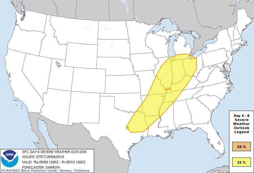
Severe Weather: While a major, widespread severe weather outbreak isn’t expected, we’ll have to keep close eyes on Wednesday evening into Thursday as a surface low tracks into the Great Lakes and drags an associated cold front into a warm and rather muggy air mass in place. Though still several days out, the potential is present for a few strong to severe storms, including large hail and damaging wind threats.

Summary: Another active week is ahead, including a couple rounds of more widespread shower and thunderstorm activity. Most concentrated storm activity should come Wednesday evening into Thursday and feature the potential of locally heavy rainfall. Widespread rainfall this week should total 1″ to 1.5″ with locally heavier totals. The bulk of this rain will fall Wednesday into Thursday. Looking further ahead, the good news here is that high pressure looks to build in as we get set to wrap up the work week and head into next weekend, helping to supply a period of dry weather Friday and throughout the weekend. (Fingers are crossed).

Permanent link to this article: https://indywx.com/2019/05/04/agwx-and-weekly-severe-weather-outlook-2/

All-Access Video: Sunshine Returns Sunday; Another Busy Week Ahead…

You must be logged in to view this content. Click Here to become a member of IndyWX.com for full access.  Already a member of IndyWx.com All-Access?  Log-in here.

Permanent link to this article: https://indywx.com/2019/05/04/all-access-video-sunshine-returns-sunday-another-busy-week-ahead/

Wet Pattern Not Just An OHV Problem…

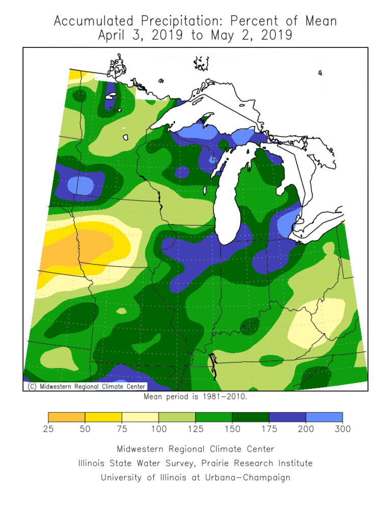
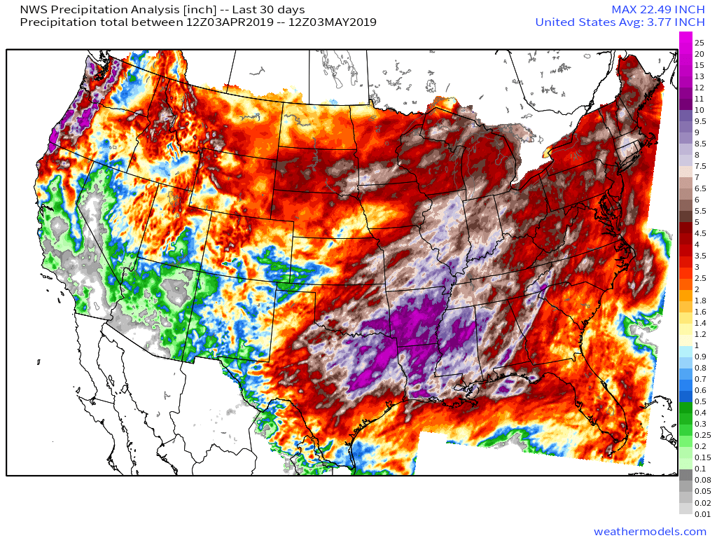
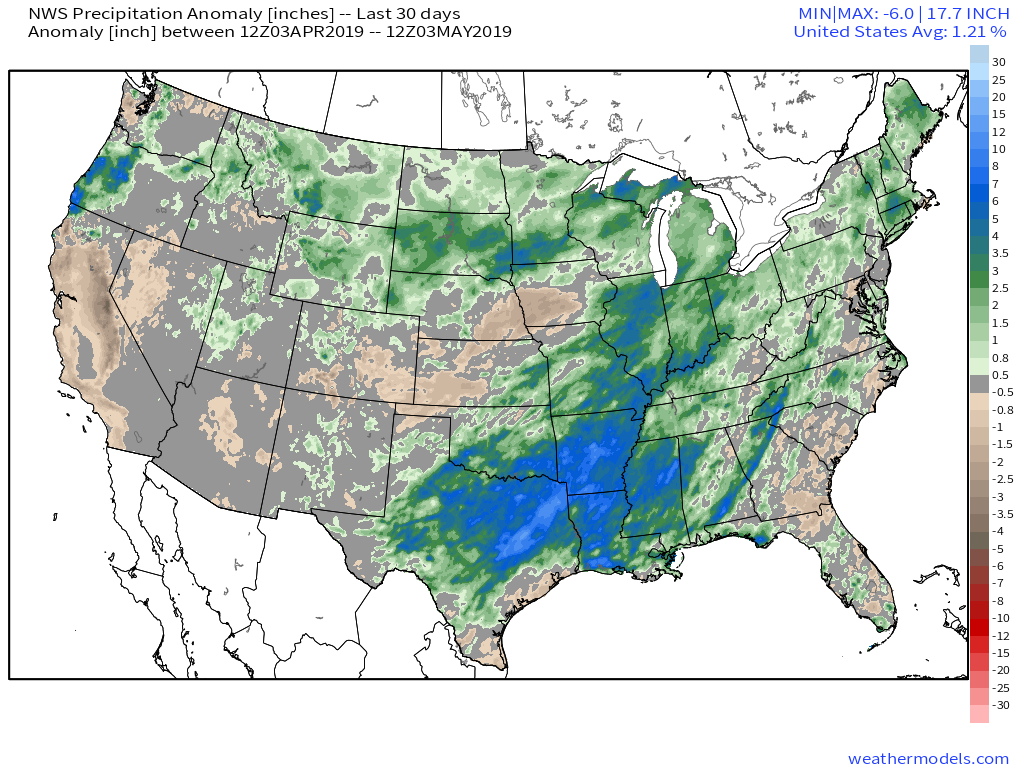
Rain has been dominating the weather pattern lately. A widespread portion of the Ohio Valley is running 125% to 175% of mean over the past (30) days. More specific to central Indiana, the bulk of this fell during the back half of April.

When we broaden out the scale, we note this wet pattern isn’t just an Ohio Valley problem, but focusing the heaviest rain on the Ark-La-Tex region.

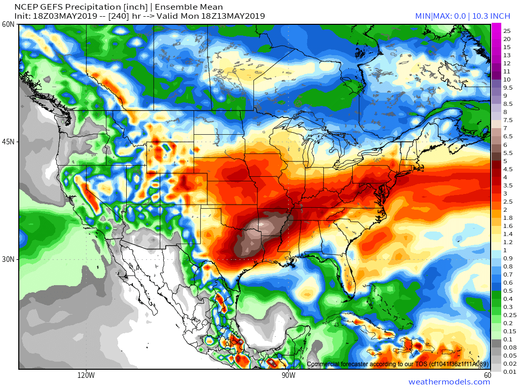
Unfortunately, when we look ahead to the upcoming couple of weeks, the pattern will continue to favor heavier than normal rainfall- not only locally, but especially centered in the area just mentioned- eastern TX, AR, and LA.

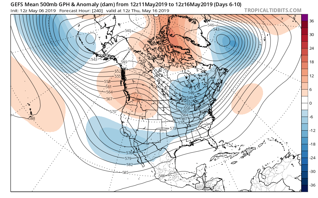
The reason behind this active and wet pattern? A persistent southeast ridge and mean trough digging into the southwest. This, combined with unseasonably cold air across the northern tier, helps set up a battle “in between” (from the s-central Plains into the Ohio Valley). Factor in the broad southwest flow aloft, and multiple disturbances will track in a southwest to northeast fashion next week, enhancing rain intensity and coverage at times. In parts of the Ark-La-Tex region, as much as 8″ to 10″ of rain may fall over the upcoming 10-days.

The excessive rainfall can also impact the upcoming season and we’ll dig in deeper here next week with our 2019 Summer Outlook.

Permanent link to this article: https://indywx.com/2019/05/03/wet-pattern-not-just-an-ohv-problem/

All-Access Video: Wet KY Derby; May Pattern Check-Up…

You must be logged in to view this content. Click Here to become a member of IndyWX.com for full access.  Already a member of IndyWx.com All-Access?  Log-in here.

Permanent link to this article: https://indywx.com/2019/05/03/all-access-video-wet-ky-derby-may-pattern-check-up/

All-Access Morning Video: Timing Out Rain Coverage Into The Weekend; Looking Ahead To A Continued Wet Pattern…

You must be logged in to view this content. Click Here to become a member of IndyWX.com for full access.  Already a member of IndyWx.com All-Access?  Log-in here.

Permanent link to this article: https://indywx.com/2019/05/02/all-access-morning-video-timing-out-rain-coverage-into-the-weekend-looking-ahead-to-a-continued-wet-pattern/

IndyWx.com