Category: Christmas/ Thanksgiving

Damp At Times Today; Colder Air Coming…

Sat.

Sun.

Mon.

Tue.

Wed.

Thr.

Fri.

Status-weather-showers-scattered-icon RainSnow Status-weather-clouds-icon Status-weather-clouds-icon Status-weather-clouds-icon Status-weather-clouds-icon RainSnow

3748

2837

26/ 37

25/ 31

1725

1932

2636

Highlights:

  • Saturday Showers
  • Arctic Air Pours In To Close 2014
  • Bigger Storm Late Next Week

Showers Around…The first round of light rain moved through central Indiana during the early morning hours and has now pushed into extreme eastern portions of the state and into Ohio.  While low clouds and areas of fog will remain, we should be dry through a large portion of the late morning into the early afternoon. Showers will then redevelop later this afternoon and tonight as a cold front draws closer.  We’re not looking at any sort of heavy rain and temperatures will be mild for this time of year.

Colder Air Pushes In To Close 2014…A cold front will move through the area early Sunday.  Cold air may help change light rain to a light wintry mix/ snow flurries before coming to an end Sunday morning.  The bigger story will be a much colder air mass that will push south and lead to a cold close to 2014 (fitting, considering the year as a whole has been colder than normal).  Unfortunately for snow lovers out there we won’t have any moisture around to lead to snowy times.

Storm System Brews Late Next Week…A significant storm system is on the charts by Friday, but we want to be very clear when we say that the range of model solutions varies from a warmer and mostly wet event to one that’s much colder and primarily a winter storm.  Which solution is correct?  That’s virtually impossible to say at this point.  One could actually argue for and against the wide range of possibilities with some of the pattern developments and teleconnections as of late.  Stay tuned.

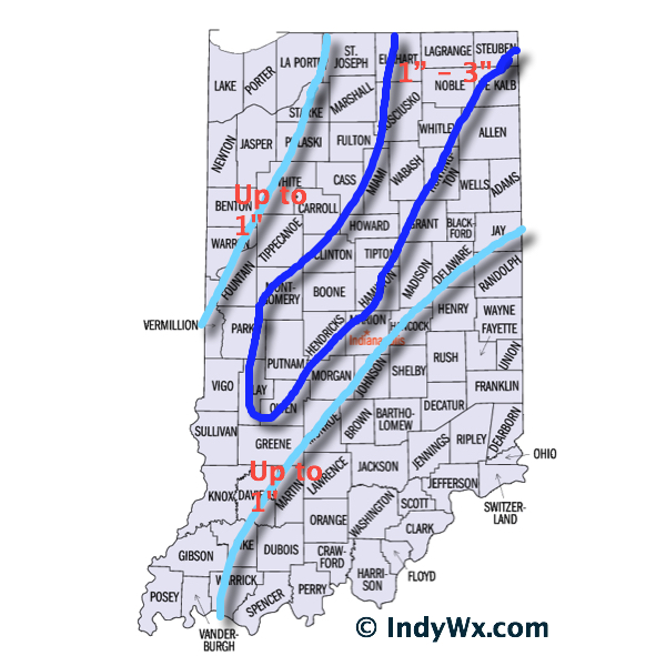
Upcoming 7-Day Precipitation Forecast:

  • 7-Day Rainfall Forecast: 0.20″ – 0.40″
  • 7-Day Snowfall Forecast: Dusting – 1″

Permanent link to this article: https://indywx.com/damp-at-times-today-colder-air-coming/

Catching Up On Friday

I hope this finds you coming off a blessed Christmas spent with family and friends! As you venture out this morning know that several reports of slick spots have come…

You must be logged in to view this content. Click Here to become a member of IndyWX.com for full access.  Already a member of IndyWx.com All-Access?  Log-in here.

Permanent link to this article: https://indywx.com/catching-up-on-friday/

Merry Christmas From Our Family To Yours…

Most importantly, from our family to yours, here’s wishing you a very Merry Christmas.  We can’t tell you how much your support and friendship means to us and it’s been a true pleasure and honor getting to know some of our loyal viewers over the past year.  Here’s to a fun and exciting year ahead of tracking weather across central Indiana!

merry_christmas_2013-HD

Thankfully the storm that’s been a true headache over the last week is almost outta’ here (good riddance)!  It’ll leave some sleet and scattered snow showers tonight as colder air works in, but, unfortunately, it’s not going to be a white Christmas this year.

Forecast radar during the overnight shows scattered snow showers across central Indiana, but marginally cold air and relatively warm ground temperatures will prevent much, if any, accumulation:

hrrr_ref_indy_10

We’ll have new challenges ahead in the weather department, but we’ll tackle those later tomorrow.  Enjoy your Christmas Eve and thank you again for your support of IndyWx.com!  Merry Christmas!

Permanent link to this article: https://indywx.com/merry-christmas-from-our-family-to-yours/

Detailed Christmas Eve Breakdown…

In what’s been an agonizing 6-7 days it’s only fitting that this will come down to the very end. Model performance has been poor, at best, concerning our Christmas Eve storm and given many forecasters a gray hair or two (yours truly included).

We’re going to lay out our best thinking below, but I want to be very clear when I say that we’re in a “now cast” mode for the rest of the day. It’ll be particularly important to have a means of gathering the latest weather information if you have travel plans later today.

Overnight model data shifted the track of a developing surface low east. After looking over all of the available data, we now have converged on a surface low track that moves northeast from west Tennessee into northwest Ohio. The surface low will strengthen as it moves northeast, helping wrap cold air into the system and change rain to a wet snow across central Indiana this afternoon and evening.

The tricky part comes into play when we get into the details. Banding features and associated precipitation rates will be key in determining when local communities see a transition to wet snow and ultimately how much accumulates. This won’t be a “uniform” type accumulation event.  Dynamics with this system are impressive, despite only marginally cold air. If we get into a situation where heavier banding develops it won’t take long to cool the entire column of air and result in localized moderate to heavy snow.

On the flip side, surface temperatures are mild after a day yesterday into the middle 50s. Add in the fact stated above of only marginally cold air available and precipitation intensity will be key. If precipitation isn’t heavy enough, it’ll be tough for much snow to fall, yet alone accumulate.

Bottom Line:
As stated above, this is a now cast scenario through the rest of your Christmas Eve. Given all of the data we’ve looked at, this is how we see things playing out this evening:

  • Rain falls through the morning hours
  • Rain begins to first mix with and transition to snow across west-central Indiana between 12p-2p
  • Snow begins falling across most of central Indiana by 3p-4p
  • Snowfall could be locally heavy within localized banding that sets up. If this is the case, snowfall rates would be heavy enough to overcome relatively mild road surfaces and create travel issues.
  • Snow diminishes to flurries by 8p
  • Winds will gust in excess of 30 MPH this afternoon and evening

ChristmasEveSnowfall

Permanent link to this article: https://indywx.com/detailed-christmas-eve-breakdown/

Video Update On Rain To Snow Christmas Eve; More On The Days Ahead…

Good evening, friends!  Here’s an update on our latest thinking Christmas Eve and the coming days…. Have a great night!

You must be logged in to view this content. Click Here to become a member of IndyWX.com for full access.  Already a member of IndyWx.com All-Access?  Log-in here.

Permanent link to this article: https://indywx.com/video-update-on-rain-to-snow-christmas-eve-more-on-the-days-ahead/