
You must be logged in to view this content. Click Here to become a member of IndyWX.com for full access. Already a member of IndyWx.com All-Access? Log-in here.
Category: Christmas/ Thanksgiving
Permanent link to this article: https://indywx.com/welcome-to-meteorological-winter/
Nov 28
Iron Bowl Saturday: December Rambles…
This is a special day in the McMillan house. Iron Bowl Saturday only comes around one day a year… Needless to say, the Auburn flags have been on the vehicles since Wednesday, we’re decked out in our orange and blue, and game faces are on for this evening’s matchup. WAR EAGLE!
As we get set to flip the calendar to December, we wanted to post some latest thinking.
Let’s take a look at the latest teleconnections. As we’ve been talking, there’s a lot of “noise” in model land, including conflicting signals. The positive NAO and AO argue for warmer than average conditions, while the positive PNA suggests chillier than normal times should prevail.
We wanted to post the latest model predictions of each teleconnections, courtesy of Weatherbell.com. Additionally, courtesy of madusweather.com, here’s what each teleconnection “phase” would normally lead to in December.
NAO


AO

PNA

 Simply based on the teleconnections, you would build a December forecast that would lean more warm than cold, as the short term positive AO and NAO should trump the positive PNA. As we look at the month, as a whole, the AO and NAO are forecast to trend more neutral, while the PNA remains solidly positive. Does this suggest colder air, relative to normal, would invade mid and late month? – Certainly something to watch.
Additionally, the latest Southern Oscillation Index (SOI), has begun to take a negative hit. This is after weeks of positive SOI values- relative to the base state.

While it takes a while to impact the pattern, locally, this negative hit does suggest mid and late month could be a bit more interesting from a wintry perspective. We shall see.
The CFSv2 remains very consistent on a warm month, relative to normal, particularly across the northern tier.

While we can’t post the European weeklies here, the latest run suggests colder, and stormy times around Christmas week. Now, we should also note the overall performance of the Weeklies hasn’t been as accurate compared to normal over the past few months, but it’s another interesting trend to keep an eye on.
The MJO will begin the month in Phase 3 before going into the “wheel house.” All-in-all, we don’t get a “hat tip” from the expected monthly MJO forecast, with the exception of Phase 3 to begin (warm phase).

 To sum up: Long range forecasting is always a gamble. Only the good Lord knows what the future holds. That said, there are times when we feel more confident about our long range, monthly outlooks, more so than normal.
We’ll lean warmer than normal for December (+ 1.5 at IND), and this really plays into our Winter Outlook (slow start expected with the emphasis on the cold and snow mid and late winter), but that doesn’t mean we’re expecting a “boring” month. Keep in mind November has been both warmer AND snowier than normal, with a very busy 2nd half of the month.
We’ll have plenty of challenges to handle as we rumble through the month no doubt, but we expect the positive AO and NAO to trump the positive PNA to start to the month. As we progress into mid and late month, we’ll have to be on alert for potential impacts of that significant SOI hit to open the month. We’ll also keep the Weeklies in check to see if the colder, stormy look Christmas week remains. It’ll be fun, as always.
To close, here’s one more emphatic WAR EAGLE from our home to yours! 🙂
Permanent link to this article: https://indywx.com/iron-bowl-saturday-december-rambles/
Nov 27
Extended Stretch Of Raw Conditions…
 Highlights:
- Periods of rain
- Turning colder
- Finally begin to dry things out
We sure hope you enjoyed those pleasant conditions on Thanksgiving Day, as rain (and eventually colder air) is settling in for the long haul.
The overall set-up shows a cold front slicing it’s way through the mid section this morning. This front will continue to slowly settle southeast and much colder air will “ooze” into the area directly behind the boundary later tonight and Saturday. Unfortunately, once the front passes to our south, additional disturbances will move along the front and enhance rain across our area from time to time over the weekend.
Here’s a snap shot, courtesy of Weatherbell.com, of what we the surface map/ simulated radar may look like as we rumble through the Thanksgiving weekend.


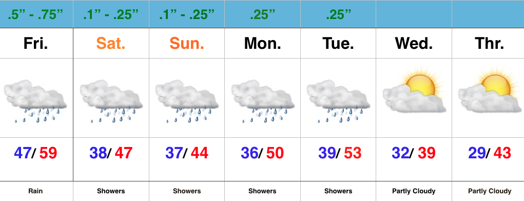
 As mentioned above, the temperature story will also be a focal point later tonight. Notice the incredible difference within just a matter of miles as we go deeper into the weekend. While central IN will be in the “transition” period tonight, all of the area will be on the cold side of the boundary Saturday. That forecast high in the upper 40s that you see above in our 7-day will be at midnight as most of tomorrow will be in the upper 30s/lower 40s.

 We’ll continue to deal with unsettled and rather “raw” conditions into the early portions of next week, but we should finally be able to shake the damp conditions by Wednesday. We’ll continue to keep a close eye on yet another system late next week, but models keep this storm to our south as of now. Stay tuned.
Permanent link to this article: https://indywx.com/5767/
Nov 26
Nice Today, But A Wet And Raw Weekend Coming…
 Highlights:
- Extended wet and raw stretch of weather
- Turning colder next week
First and foremost, happy Thanksgiving from all of us at IndyWx.com! We hope you have a blessed day with friends and family and we’re incredibly thankful for your support of what we’re doing here at IndyWx!
Thanksgiving Day, itself, will be filled with very pleasant weather as a SW flow transports mild air northbound and results in highs around 60 this afternoon with a gusty breeze in place. A scattered shower is possible, but it’s not until we get to late tonight and Black Friday that we expect more widespread rains across the region.
Rain will settle in Friday and temperatures will also go the wrong direction come evening as a cold front passes through the area. This is the first in a series of rain that we’ll deal with over the Thanksgiving weekend. A second surge of rain will arrive Saturday into Sunday, followed by a third push of rain Monday. All total, between 1-2″ of rain is a good bet across a widespread portion of the region between Friday and Monday.
Colder air will settle in by the middle of next week. We’ll have to closely monitor as a fourth system will be in play. It’s far too early for details, but we’ll keep an eye on things to see if some sort of wintry precipitation may be in play late next week…
Permanent link to this article: https://indywx.com/nice-today-but-a-wet-and-raw-weekend-coming/
Nov 24
Heavy Rain Thanksgiving Weekend And What Lies Ahead Later Next Week?
You must be logged in to view this content. Click Here to become a member of IndyWX.com for full access. Already a member of IndyWx.com All-Access? Log-in here.
Permanent link to this article: https://indywx.com/heavy-rain-thanksgiving-weekend-and-what-lies-ahead-later-next-week/