VIDEO: Thanksgiving Weather; “Interesting” Open To December…
You must be logged in to view this content. Click Here to become a member of IndyWX.com for full access. Already a member of IndyWx.com All-Access? Log-in here.
You must be logged in to view this content. Click Here to become a member of IndyWX.com for full access. Already a member of IndyWx.com All-Access? Log-in here.
 Highlights:
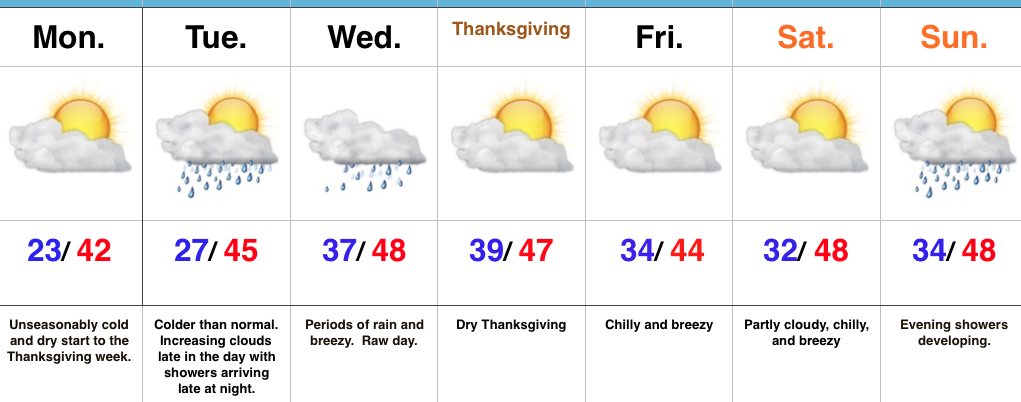
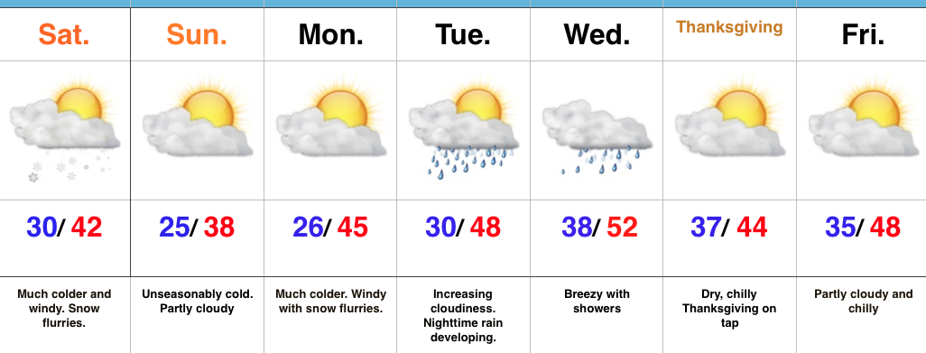
Active Week…Some folks across central Indiana are waking up to temperatures in the upper 10s this morning (looking at you Crawfordsville) and most everyone else is being greeted by lower to middle 20s out the door! It’s a very cold start to the day. Thankfully, dry conditions will remain today and through the daytime Tuesday. Clouds will be on the increase Tuesday, but we should hold off on rain until late at night. Unfortunately, the big travel day Wednesday will feature periods of rain and blustery, chilly conditions. It’ll be a raw day.
We’ll dry things out for Thanksgiving, itself, along with seasonable temperatures. Reinforcing chilly air will blow into town Black Friday and our next storm system of interest will arrive Sunday. Most of the day Sunday will feature dry conditions before rain arrives on the scene by evening.
Upcoming 7-Day Precipitation Forecast:
The 2016-2017 IndyWx.com Winter Outlook was posted on October 30th. If you haven’t had an opportunity to see it, you can here. Right out of the gate, we remain bullish on the prospects of a snowy holiday stretch this year, including above average snowfall for the month of December (average December snowfall at IND is 6.9″).
We continue to undergo that “step-down” process within the pattern, but there are growing signals that suggest the pattern takes on a very “blocky look” as we rumble into December. When we talk about a blocking pattern in this instance, we’re specifically talking about high-latitude blocking. Essentially this is when high pressure sets up in the high latitude regions (Greenland or northern Canada, for example). Textbook blocky patterns feature high pressure that sustains itself and is very persistent, leading to a “log-jam” of sorts in the weather pattern, and playing a pivotal role in locking cold, stormy weather in for lengthy periods of time across the Lower 48. Many times this is a “feedback” type scenario, meaning the early period of blocking patterns initially turns stormy and then grows progressively colder as the snowpack is laid down further and further south.
When we look at the medium-range and longer-term model data, we note the blocky pattern developing as we wrap up November and rumble into December. The European, Canadian, and GFS ensemble data all shows the stormy look evolving.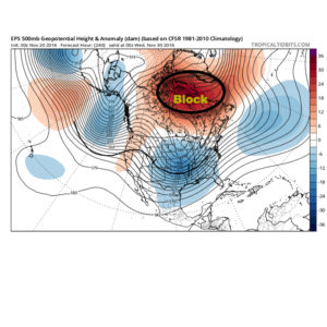
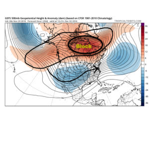
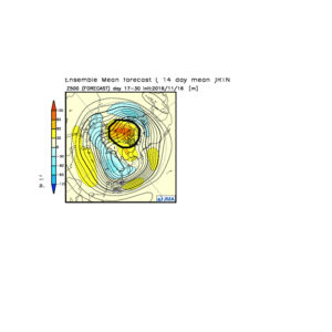
 The Weeklies also show this pattern in the longer-term. While we can’t show the European data here (due to licensing), we can show the JMAs. Again, note the high-latitude blocking.
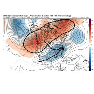
 Active times are ahead as a busy storm track develops. Perhaps the scene for many will look a little something like this as we push into the Christmas season…
 In the meantime, gas up the snow blower and sharpen the snow shovel. If our idea is correct, a snowier than average December will come out of this blocky pattern.
 Highlights:
Pull Out Those Heavier Coats…Last night’s cold front hit with authority and will likely be looked back on as the “game changer” between the warm, quiet fall we enjoyed and colder, more active times ahead. Today is much colder with snow flurries and scattered snow showers. Gusty NW winds will feature wind chills in the 20s through the daytime before falling into the 10s tonight.
Calm, cold weather will continue into early next week before our next storm system blows into town Tuesday evening. Clouds will increase through the day Tuesday and rain will arrive at night. The big travel day before Thanksgiving looks blustery and wet with showers (especially during the first half of the day). We’ll get the system out of here to allow for a dry, chilly Thanksgiving.
Looking ahead, another system of “interest” is on deck late next weekend or early the following week. Timing and details are far from etched in stone with this being 7+ days out, but the potential is there for this to feature a wintry component…
Upcoming Precipitation Forecast:
You must be logged in to view this content. Click Here to become a member of IndyWX.com for full access. Already a member of IndyWx.com All-Access? Log-in here.