Category: Christmas/ Thanksgiving

Initial Analog Set For Winter ’23 – ’24…

Updated 09.03.23 @ 9:22a

The extended stretch of quiet weather has given us time to finalize the initial set of analogs we’ll lean in on for the upcoming winter. Speaking of that, our annual Winter Outlook will be published Friday, October 27th.

While long range seasonal models differ on the placement of warmest sea surface temperature (SST) anomalies, we’re refraining from going “all-in” on a modoki Nino event as of now. This is something that no doubt will have our attention as we go through the course of the next several weeks. It’ll be interesting to watch the trends. The modoki, or central based, warm event would go a long way in upping the ante for a colder, stormier winter, locally. This is something that’s possible but we still have more questions than answers with how this evolves.

SST configuration as of September 1, 2023:

Our initial set of analogs includes the following years:

  • 1957-1958
  • 1972-1973
  • 1991-1992
  • 2002-2003
  • 2009-2010
  • 1982-1983
  • 2015-2016

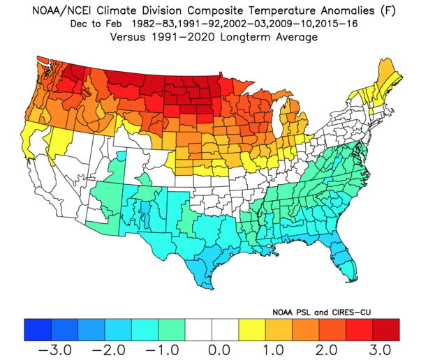
We’re looking at 1st year Nino events of moderate to strong intensity. (Most modeling peaks this event in the +1.5 to +2 range in Nino region 3.4). In addition, we’re also looking at critical SST configuration in the NPAC and northwest Atlantic. Out of the list above, heaviest focus as of now centers on ’82-’83, ’91-’92, ’02-’03, ’09-’10, and ’15-’16.

A blend of those years gives us the following temperature and precipitation pattern for meteorological winter:

Temperature

Precipitation

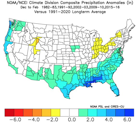
There’s a lot more that goes into our seasonal outlooks than simply taking a blend of analogs, but this will serve as a nice starting point from this distance. It’ll be very interesting to watch the migration (or lack thereof) of warmest SSTs currently “tucked in” to Nino regions 1+2 and 3 into potentially a more central, or region 3.4 event.

Make it a great Labor Day weekend and know we’ll have much more to come in the weeks ahead on our winter ’23 – ’24 thoughts…

Permanent link to this article: https://indywx.com/initial-analog-set-for-winter-23-24/

Merry Christmas To All: Another Accumulating Snow Event On Deck Followed By A Significant Warm-Up As We Close Out The Year…

Updated 12.25.22 @ 8:11a

From our family to yours, here’s wishing you a blessed and very merry Christmas!

Our Christmas morning is getting off to another frigid start, with all of the immediate region featuring temperatures just above the 0° mark (wind chill values remain well below zero).

7:45a temperatures Christmas Day
8a wind chill values Christmas Day

All but far northeastern IN is at least seeing sunshine this morning. We can thank that lake influence for keeping our northeastern neighbors overcast this morning.

53% of the country is enjoying a White Christmas. That’s the most since back in ’09 when 63% of the country was snow covered on Christmas Day.

Speaking of snow, our next snow maker will arrive overnight and remain with us through our Monday. In general, we anticipate 1″ to 2″ of snow with this system with a couple of 3″ reports. While certainly not a heavy snow event, expect slick travel Monday thanks to the recent frigid stretch of temperatures. Most persistent snow will likely fall from late morning into the early afternoon across central Indiana.

A couple of days of uneventful weather will follow our snow maker. Sunshine will return Tuesday. While still cold, temperatures will moderate close to the freezing mark for daytime highs.

Our airflow will then back around to the southwest Wednesday and this will be the beginning of a significant period of moderation. “Zoom, zoom, up and away” is how we’ll label the temperature regime heading into next weekend, including New Year’s Eve with highs into the lower 60s for many. Talk about another infamous “snap back” warm-up following an arctic intrusion. (Don’t worry winter weather fans, we’re already eyeing the return of our next cold, snow pattern by mid-January).

The trade off to the warmer weather? An extended period of gloom. Clouds will increase Wednesday and eventually give way to drizzle that will turn into periods of rain Thursday through next weekend. The heaviest rain will likely fall New Year’s Eve as an area of low pressure lifts north into the western Great Lakes.

Permanent link to this article: https://indywx.com/merry-christmas-to-all-another-accumulating-snow-event-on-deck-followed-by-a-significant-warm-up-as-we-close-out-the-year/

VIDEO: Another Snow Maker On Deck; Warmer, Wetter Pattern Evolves Next Week…

Updated 12.24.22 @ 8:40a

You must be logged in to view this content. Click Here to become a member of IndyWX.com for full access.  Already a member of IndyWx.com All-Access?  Log-in here.

Permanent link to this article: https://indywx.com/video-another-snow-maker-on-deck-warmer-wetter-pattern-evolves-next-week/

VIDEO: Long Range Update And Short-Term Look At Our Next Snow Maker…

Updated 12.23.22 @ 7:58a

You must be logged in to view this content. Click Here to become a member of IndyWX.com for full access.  Already a member of IndyWx.com All-Access?  Log-in here.

Permanent link to this article: https://indywx.com/video-long-range-update-and-short-term-look-at-our-next-snow-maker/

VIDEO: Blizzard Conditions Into Friday; Another Snow Maker Arrives Just After Christmas…

Updated 12.22.22 @ 5:54p

You must be logged in to view this content. Click Here to become a member of IndyWX.com for full access.  Already a member of IndyWx.com All-Access?  Log-in here.

Permanent link to this article: https://indywx.com/video-blizzard-conditions-into-friday-another-snow-maker-arrives-just-after-christmas/