Category: CFSv2

VIDEO: Summer-like Feel Wednesday Helps Fuel Storm Chances; Longer Range Thoughts…

For the first time this spring, you’ll really notice the muggy nature to the air by Wednesday afternoon, as dew points climb from the pleasant 50s (Wednesday morning) to near…

You must be logged in to view this content. Click Here to become a member of IndyWX.com for full access.  Already a member of IndyWx.com All-Access?  Log-in here.

Permanent link to this article: https://indywx.com/video-summer-like-feel-wednesday-helps-fuel-storm-chances-longer-range-thoughts/

Looking Ahead To The Merry Month Of May…

Folks are growing tired of the cold and snow, and for good reason; it’s mid-April for goodness sakes.  As of today, we’re currently ranked as the 5th snowiest spring (March-May) in recorded history, with Indianapolis recording 14.2″ thus far.  By the way, we’re only .3″ from moving into the 4th place spot.

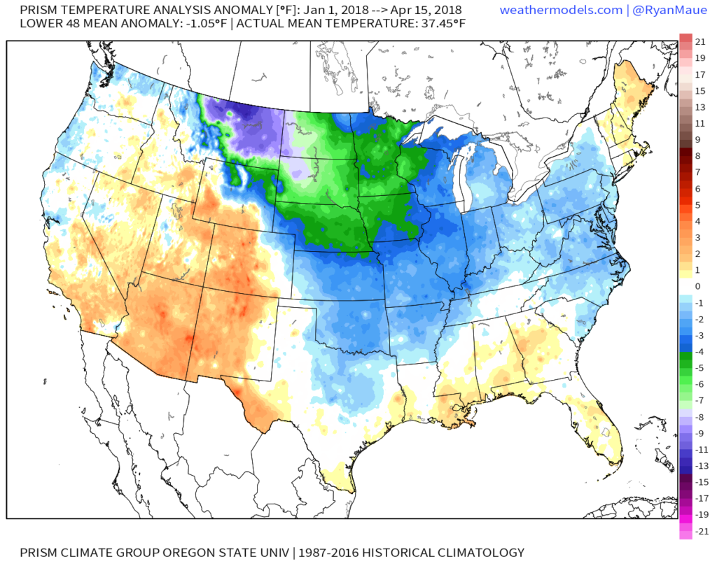
With that said, it’s not just April that’s been unusually cold and snowy, but the entire year thus far.  As of April 15th, year-to-date CONUS temperatures are running more than 1° below average:

More specific to Indianapolis, here’s the monthly temperature breakdown so far for 2018:

  • April: 5.7° below normal (MTD)
  • March: 3.3° below normal
  • February: 5.6° above normal
  • January: 3.0° below normal

As we look ahead, there are a couple of key items that we’re monitoring closely to get a better idea as to where this pattern is heading as we rumble into the merry month of May:

NAO- does it show signs of finally flipping to a positive state with any sort of duration?

MJO- does it go into the “wheelhouse” or continue to rumble into the milder phases (5 and 6 this time of year)?

The North Atlantic Oscillation (NAO) is a bit troubling as it shows signs of heading towards a negative phase once again as we open the month of May.  This would promote the threat of colder than normal temperatures continuing in early May. With that said, May is the first month of the next several (until winter returns) where the overall influence of the NAO state begins to lessen it’s grip.  Unlike from the mid and late winter months into the early spring (Jan through April), mid and late spring, through the fall, isn’t controlled by the NAO.  With May being a “transition” month, we’ll favor a colder than average pattern continuing during the early portion of May as the NAO looks to trend negative.  As we move towards mid and late month, we won’t rely on the NAO like we have been lately as the said influence “wanes.”

The Madden Julian Oscillation (MJO) is forecast by most data to head towards the “null” phase.  The consensus of modeling takes it into the wheelhouse after traversing Phase 3 (present) which is a cold phase.  The end result?  Unfortunately, we can’t rely on the MJO with any sort of confidence from this distance for the month of May.

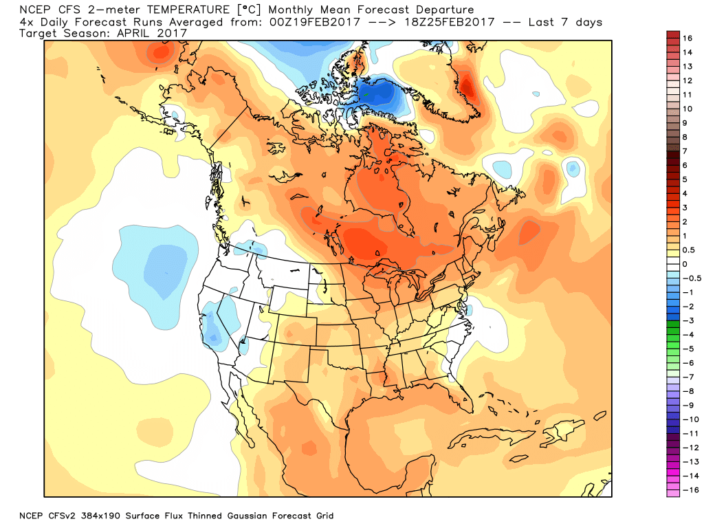
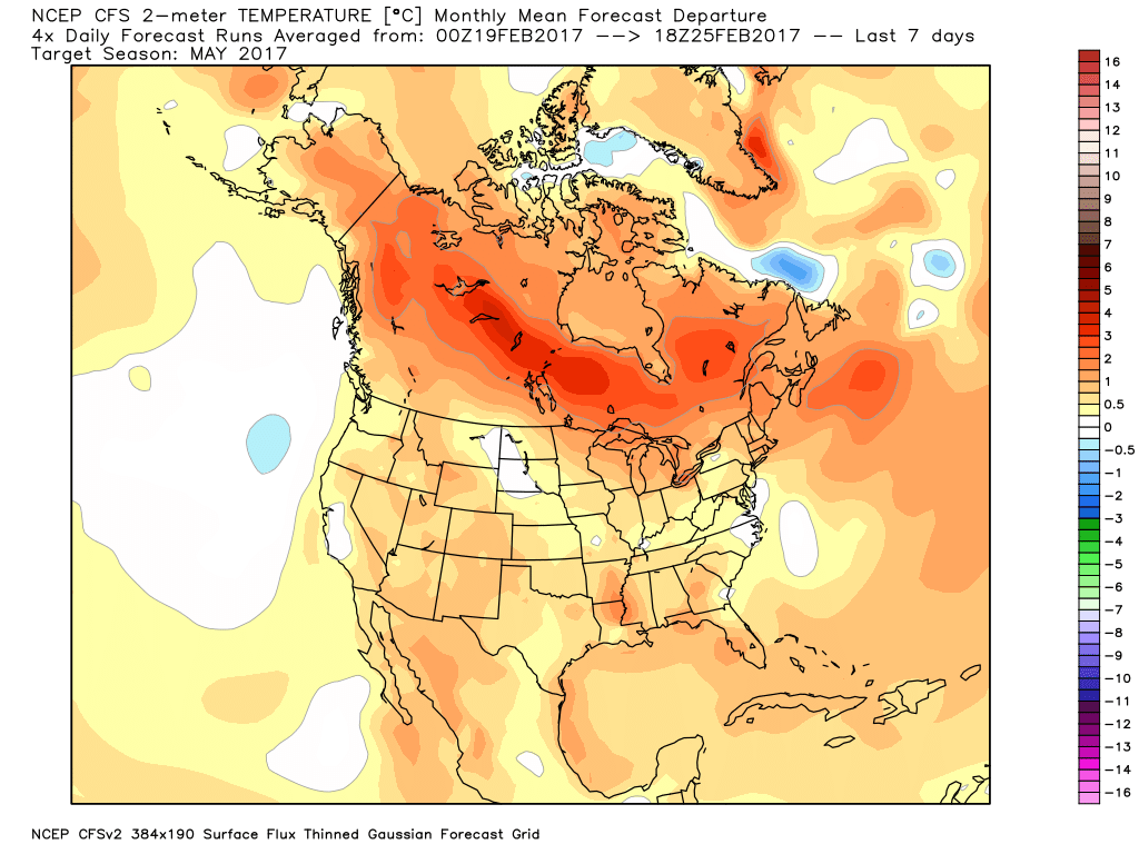
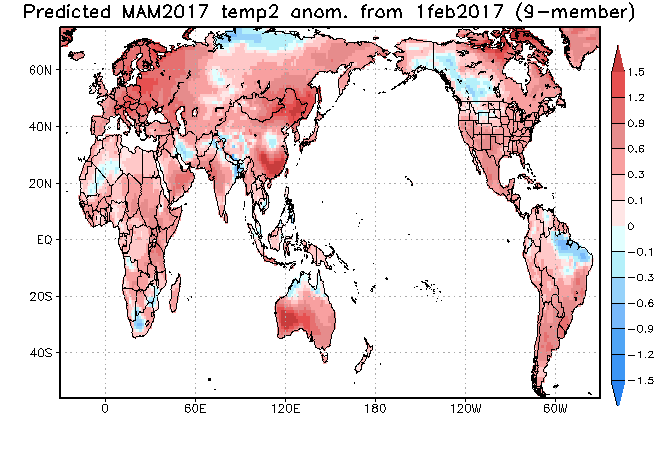
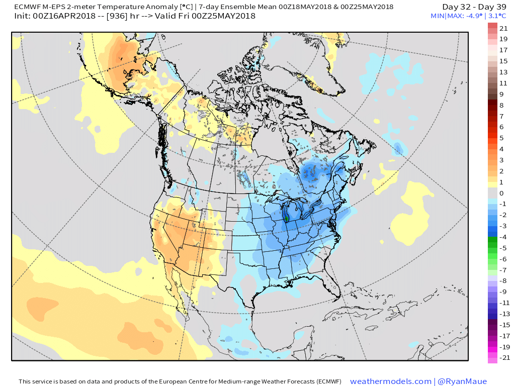
Looking at the data itself, the CFSv2 and European Weeklies (just to name a couple) show conflicting ideas.  The CFSv2 (courtesy of weatherbell.com) is in the warmer than normal camp for May while the NEW European Weeklies (courtesy of weathermodels.com) suggest the chill lingers throughout the month.

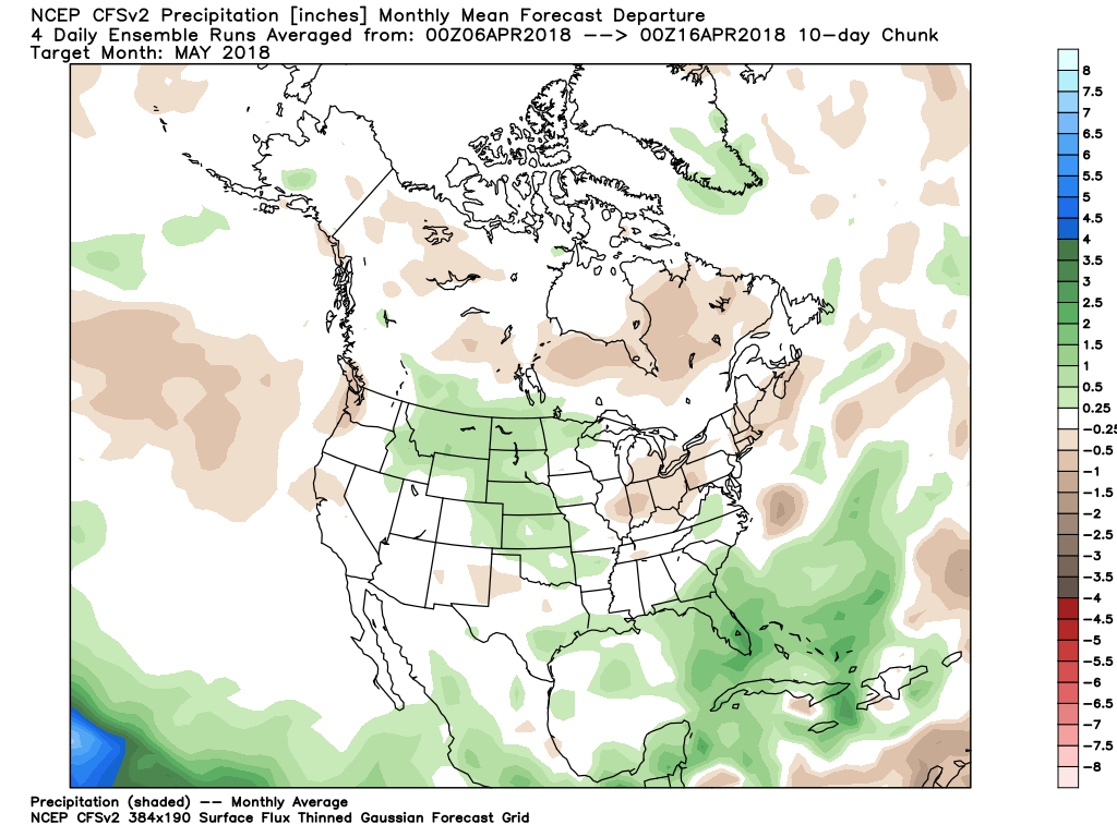
While we have conflicting temperature ideas, both suggest a drier than average month emerging:

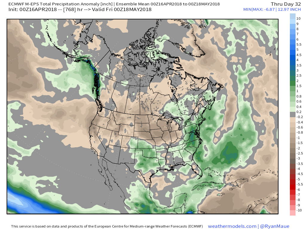
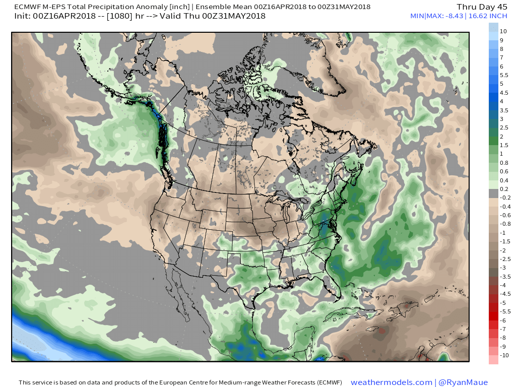
At the end of the day, our call on May’s forecast from mid-April would be for an early cooler than average start before flipping towards more of a seasonable to slightly warmer than normal regime.  Our idea all along this spring has been that when this pattern flips, the potential is present to jump right to a summery feel.  In the face of the new European Weeklies, we still feel this warmer idea mid and late May is on the table.  We’re in agreement with the data of a drier than average month.

Permanent link to this article: https://indywx.com/looking-ahead-to-the-merry-month-of-may/

VIDEO: Saturday Morning Thoughts On Late March…

In the midst of trying to keep Bo, our youngest golden doodle, from becoming a tremendous distraction in this morning’s video, here are some thoughts on what lies ahead over…

You must be logged in to view this content. Click Here to become a member of IndyWX.com for full access.  Already a member of IndyWx.com All-Access?  Log-in here.

Permanent link to this article: https://indywx.com/video-saturday-morning-thoughts-on-late-march/

Weekly Update: JMA, CFSv2, Euro…

The general consensus between the JMA and CFSv2 is that warmth is the story through Week 2, especially this weekend into next week.  JMA first:

Week 1

Week 2

Weeks 3-4

Before we show the CFSv2, a couple take-aways from the JMA:

  • Warmth is most impressive early on (through next week), relative to average
  • As cold tries to push, active times will return (finally) to the region from Week 2 on

Now…the CFSv2:

Weeks 1-2

Weeks 3-4

Key take-aways:

  • Similar to the JMA, warmth is most impressive early on before a “fight” develops thereafter.

While we can’t show the European Weeklies due to licensing issues, they paint a similar theme, overall.  They sing a similar song in the short-term for warmth to close the month, but are much more bullish on the transition to a colder than average first half of October compared to the CFSv2 and JMA.

To sum things up, confidence is high on a summer-like regime to engulf the region through the balance of the second half of September as a ‘Nina-ish pattern takes hold.  Late-season summer warmth will rule through next week, including highs in the 85°-90° range at times- developing as early as this weekend.  This, of course, comes on the heels of an unusually early cool start to meteorological fall (IND is running a whopping 6° below average, MTD).  After the warmth dominates, a transitional pattern should ensue, including more active times (wetter than average as we close September and open October), along with “pops” of colder air.  That said, a consistently positive southern oscillation index has us “raising an eye brow” to the aggressively cold start to October such as the Euro implies… Stay tuned.

Permanent link to this article: https://indywx.com/weekly-update-jma-cfsv2-euro/

Looking Ahead To Spring…

Meteorological spring begins in a few days (runs March through May).  We’ve already touched on the expected busy severe weather season and want to dedicate this post towards looking deeper into the weather pattern and the resulting precipitation and temperature impacts.

The latest longer-range data continues to be in very good agreement on the upper air pattern.  In short, the balance of the spring season looks to offer up a continued theme of warmer than average temperatures for our region.  (Not saying we won’t have to deal with a wintry “trick or two” over the first couple weeks of March).  When we look at spring, as a whole, we believe it’ll be one known more for the warmth and active, stormy times.

CFSv2 March Temperature Anomalies

CFSv2 April Temperature Anomalies

CFSv2 May Temperature Anomalies

JAMSTEC March through May Temperature Anomalies

The latest JMA monthly idea is one that has to raise an eye brow as it would paint an early summer across the Ohio Valley and Great Lakes.  Anomalous warmth (true summer-like air) would develop with a strong ridge over the Great Lakes and northeast.  This is something we’ll have to keep an eye on.  A big caveat here is how strong and quickly the coming El Nino develops.  It should be noted, El Nino years can feature some of the hottest air early, not late, in the summer season (relative to averages), and the JMA would, indeed, yield an early summer with such a look.

JMA May Forecast 500mb Pattern

It should also be noted modeling is suggesting a wet look, locally, especially during the early portions of spring.  The JAMSTEC and JMA are particularly bullish on a wet pattern.

JAMSTEC March through May Precipitation Anomalies

JMA March through May Precipitation Anomalies

The CFSv2 hits the wet March hard before a drier regime mid and late spring.

March Precipitation Anomalies

April Precipitation Anomalies

May Precipitation Anomalies

In closing, we seem to have a bit of a bumpy ride in front of us as meteorological spring begins.  While Old Man Winter hasn’t been seen much as of late, don’t be shocked if he makes his presence felt a few more times through the first half of March- both from a cold and snow perspective.  That said, data really points towards more of an overall warm regime developing the second half of the month, and continuing through the majority of spring, for that matter.  We’re keeping a close eye on May for an early summer-like feel to take hold, locally.  Subsequent JMA updates will be monitored closely.  We also remain confident of an active severe weather season.  Note the tendency of model data (above) to pull the mean trough position to the northwest March into April.  The clash of late-season wintry conditions west, combined with unseasonably warm temperatures across the east (not to mention the warmer than average Gulf of Mexico) likely will equal busy times as we progress through the spring severe weather season.

Permanent link to this article: https://indywx.com/looking-ahead-to-spring/