Category: CFSv2

Long Range Update And Summer Preview…

One more unseasonably chilly spell awaits late-March (behind our mid-March spring “tease”), but we continue to believe an unseasonably warm stretch of weather gets going by the last few days of the month- continuing into April. Furthermore, meteorological spring overall continues to look warm, relative to average, for central Indiana. In the event you missed our Spring Outlook earlier, it can be found here.

However, what follows the late-March set-back is a more significant and sustained push of unseasonably warm conditions.

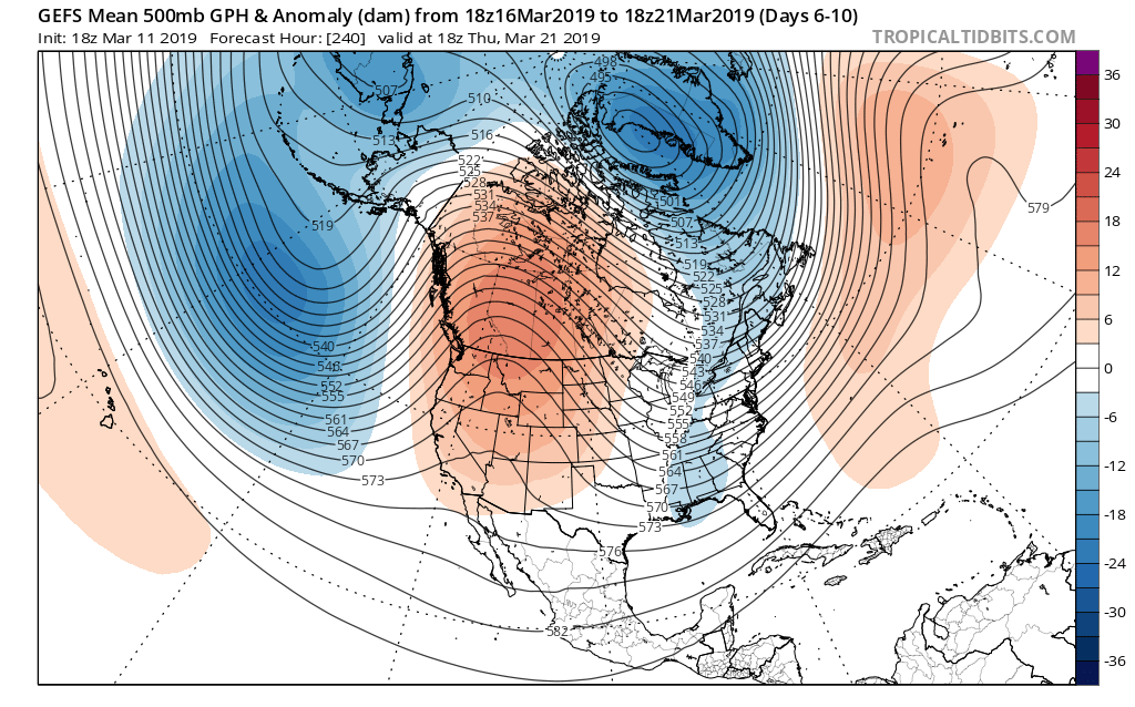
Note the positive PNA that will help drive the chilly pattern next week returns to neutral as we put a wrap on the month:

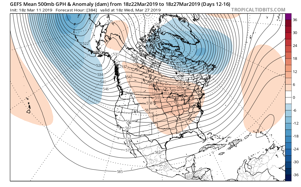
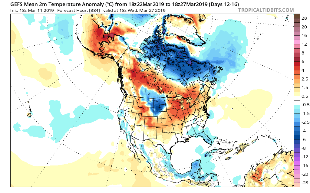
To no surprise, modeling is painting a vastly different look as we close March and open April.

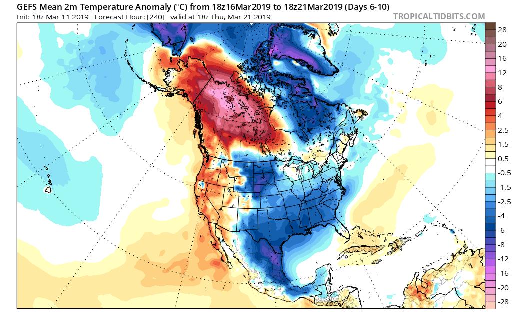
We turn cooler next week with the positive PNA in control, but this won’t last…

Note the significant change aloft (and at the surface) as we close the month and get set to head into April…

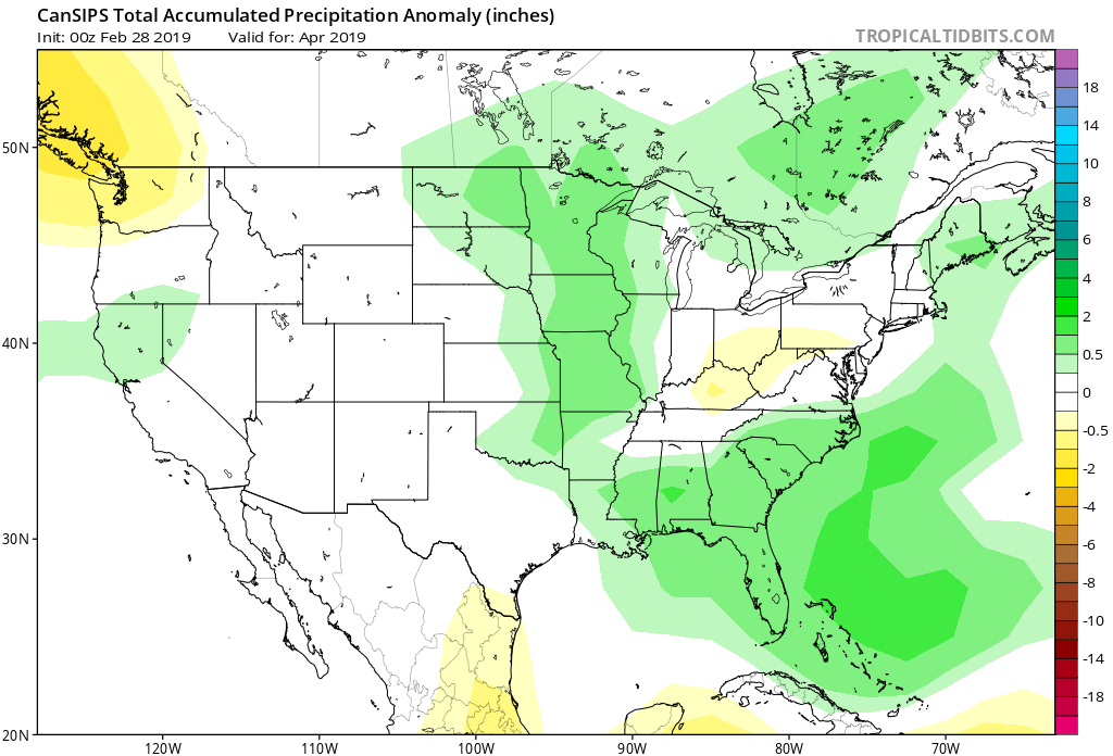
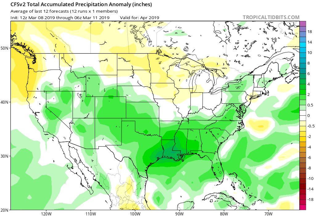
Longer term, modeling continues to give us an actual spring this year. We continue to expect average to slightly above average temperatures in April, complete with slightly above normal precipitation (with a “ramp up” in severe chances, locally).

Modeling is following suit with that idea:

It should also be noted that while not shown, the new European Weeklies in this evening also support the warmer than normal April idea.

As we look forward, we continue to research and build our summer outlook. Early indications would suggest that we transition out of an overall warmer than average spring towards a seasonal, to slightly below average, time of things this summer, complete with above normal precipitation. We, obviously, still have some time to go before the final product is ready to be published, but stay tuned. We are planning to launch our official summer outlook in early May.

Permanent link to this article: https://indywx.com/long-range-update-and-summer-preview/

Long Range Video Update: Changeable Pattern For The 2nd Half Of March Into April…

You must be logged in to view this content. Click Here to become a member of IndyWX.com for full access.  Already a member of IndyWx.com All-Access?  Log-in here.

Permanent link to this article: https://indywx.com/long-range-video-update-changeable-pattern-for-the-2nd-half-of-march-into-april/

Saturday Afternoon Video Update: Damaging Winds Develop Late Tonight; More Conversation Around The March Pattern…

You must be logged in to view this content. Click Here to become a member of IndyWX.com for full access.  Already a member of IndyWx.com All-Access?  Log-in here.

Permanent link to this article: https://indywx.com/saturday-afternoon-video-update-damaging-winds-develop-late-tonight-more-conversation-around-the-march-pattern/

All-Access Long Range Update: Walking Through March…

Recently, a “transient” pattern has dominated. This has kept any sort of long-lasting cold at bay and resulted in above normal precipitation. As we get set to close out February and welcome in a new month, a pattern change is on the horizon.

This overall shift in the pattern will drive a more sustained and significantly colder than normal regime southeast. In short, cold is set to “overwhelm” the pattern through the first couple of weeks of March. In the most extreme case (especially if we can get snow down), we will be able to challenge records at some point during the 1st (10) days of the month.

In spite of a neutral to positive AO and NAO, a significantly negative EPO and MJO rumbling through the cold late Feb and early March phases look to trump the otherwise warm signals. We also can’t forget about the significant SOI crash. Let’s dig into some of the latest data:

CFSv2


Note the modeling spreading the cold out during the Weeks 2-3 time period before gradually modifying things as we move into the middle and latter portion of March. The mean storm track shifts to the east during the first couple of weeks of the month (pattern will likely be dominated by more snow vs. rain events during this time period) before wetter than normal conditions return for the 2nd half of the month.

JMA Weeklies

Week 1
Week 2
Weeks 3-4

Like the CFSv2, the model overwhelms the pattern with cold during the Week 2 time period. Also similar to the CFSv2, the JMA Weeklies bring ridging back into the East and associated warmth by mid-month. While we haven’t included the precipitation anomalies in this post, the model does bring wetter than normal conditions back into the area by mid-March.

European Weeklies

The NEW European Weeklies remain consistent from Monday’s update (and data above) in delivering a very cold 1st half of March. The core of the cold looks to be centered over the upper Midwest and Northern Plains, but temperatures for the balance of the first couple weeks of the month will likely resemble what we’d expect in late January or early February vs. March. While precipitation will likely run below normal (thanks to the cold pattern), the model deliver above normal snowfall during the period. As we move into the 2nd half of the month, warmer (and wetter) conditions are shown to return.

Given all of the above, we expect the primary upper air pattern to feature a central and eastern trough through the 1st half of March before that trough settles into the West during the 2nd half of the month. This will open up the eastern portion of the country for not only warmer air, but a return of moisture-laden storm systems and the potential of strong-severe storms at times.

Permanent link to this article: https://indywx.com/all-access-long-range-update-walking-through-march/

2019 Spring Outlook…

2019 IndyWx.com Spring Outlook

Forecaster: Team; Date Issued: 02.16.19

Last spring was a tale of two seasons in itself. March (featured a foot of snow) and April were significantly colder than normal and then we shifted things to summer in May (the last month of meteorological spring was close to 10 degrees above normal). As a whole, it was a quiet severe weather season.

Despite the wild swings, at the end of the day, things “balanced out” nicely across the central Ohio Valley, including central Indiana.

As we look ahead to what the 2019 version holds, here are a few headlines that have our attention:

I. Weak Nino is behaving more like a Nina (Tropical Northern Hemisphere pattern can be thanked for this).

II. Neutral NAO is expected

III. Neutral PDO (Pacific Decadal Oscillation)

In addition, we’re paying special attention to the SST configuration in the Gulf of Mexico. A warmer than average GOM can most certainly lead to a more “hyper” severe weather season as spring gets going.

The late winter/ early spring drought monitor can give a hint where early warmth may try and get going. However, this year, we can’t rely on this tool as the Plains and East, including the heart of the #AGbelt, have seen copious amounts of moisture over the winter.

Drought Monitor as of 2/14/19
December 2018 Precipitation Anomalies
January 2019 Precipitation Anomalies

Let’s look at what the model guidance is printing out for meteorological spring:

JMA

March
April
May

CFSv2

JAMSTEC

European Seasonal

Summary

We anticipate a slightly warmer than average spring season across not only central Indiana, but the Mid West and Ohio Valley region, as a whole. A weak El Nino is expected to persist into the upcoming summer and the conditions typically associated with such should eventually show themselves (as opposed to more of a Nina-like flavor now) through the spring. We agree with the consensus of model guidance above that March is likely to feature the coldest temperatures, relative to normal, and that’s primarily due to what should be a colder 1st half of the month before more bonafide spring conditions take hold the 2nd half of the month. Precipitation is anticipated to run near average, if not slightly below average, levels through the spring. As for severe weather, we expect a much busier season than last year, especially with the warm SSTs lurking in the Gulf of Mexico.

Permanent link to this article: https://indywx.com/2019-spring-outlook/