Category: Blowing/ Drifting

Client Brief: All Systems Go For Highly Impactful Winter Storm…

Updated 02.01.22 @ 7p

Type: Severe Winter Weather

Heavy snow will fall across central IN Thursday

What: Heavy mixed precipitation, heavy snow, & strong winds

When: Wednesday afternoon through predawn Friday

Temperatures: Mid 30s, falling into the upper 10s Thursday night

Wind: NNE 15 – 25 MPH (gusts up to 30 MPH Thursday)

Blowing/ Drifting: Significant to severe (especially on east-west roadways)

Pavement Impacts: Plowing and salting will be required

Summary: While we don’t have any significant changes to this morning’s video update, we continue to draw that much closer to “show time” with this winter storm. Conditions will deteriorate from northwest to southeast as we progress through the day tomorrow, but the “main show” for immediate central IN will come late tomorrow night and through the day Thursday. It’s during this time where snowfall rates will exceed 1″/ hour for a widespread portion of the region. Simply put, if you don’t have to travel, please don’t. The added concern also remains present of blowing and drifting issues that will likely develop during the day Thursday. This will be from a byproduct of an increasingly fluffy snow (anything that falls tomorrow will be of the wet, slushy nature), thanks to higher ratios, as the arctic air pours into the region. Add in a stiff north, northeast wind of 15-25 MPH with gusts to 30 MPH and you can easily see where the problems are likely to ensue. In particular, east-west roadways in the open country are likely to drift shut by late morning or afternoon Thursday. Snowfall coverage and intensity will finally begin to diminish from northwest to southeast Thursday night. By that point, it’ll be time to bring the heavy equipment out to engage in removal of the “BIG SNOW.” We still anticipate bitterly cold (5° to 15° below zero) temperatures to take up shop Saturday morning across the region.
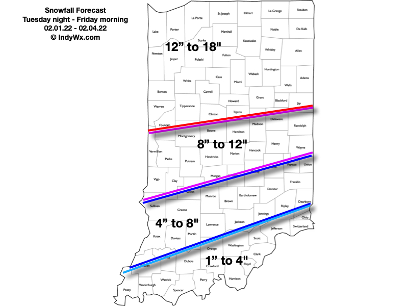
Confidence: High

Next Update: 7a Wednesday

Permanent link to this article: https://indywx.com/client-brief-all-systems-go-for-highly-impactful-winter-storm/

VIDEO: Conditions Deteriorate Wednesday; Mixed Precipitation Gives Way To Heavy Snow Wednesday Night Across Central IN…

Updated 02.01.22 @ 7:14a

Here’s our snowfall forecast. Most of what accumulates through the heart of the 8″ to 12″ zone and points south will fall with “round 2” Wednesday night and Thursday. This morning’s video update has the details!

Permanent link to this article: https://indywx.com/video-conditions-deteriorate-wednesday-mixed-precipitation-gives-way-to-heavy-snow-wednesday-night-across-central-in/

VIDEO: Long-Winded Update Of Where We Think The Pattern Is Going Into Early March…

Updated: 02.18.21 @ 7:08p

You must be logged in to view this content. Click Here to become a member of IndyWX.com for full access.  Already a member of IndyWx.com All-Access?  Log-in here.

Permanent link to this article: https://indywx.com/video-long-winded-update-of-where-we-think-the-pattern-is-going-into-early-march/

Client Brief: Snow Builds In Overnight – Predawn Thursday…

Updated: 02.17.21 @ 4:54p

Type: Impactful Wintry Weather

What: Accumulating snow

When: 2a to 9p Thursday

Temperatures: 18° to 24°

Wind: N 10-20 MPH, shifting to the NW Thursday night

Blowing/ Drifting: Considerable  

Pavement Impacts: Plowing and salting will be required

Summary: Another round of snow will lift northeast into central Indiana during the overnight and predawn hours (likely arrives into Indianapolis between 1a and 2a). As like so many of these events in the past, this will be another cold storm, meaning we’re looking at another high ratio (15-20:1) event. The dry, powdery nature of the snow will be blown and drifted around by north to northwest winds of 10-20 MPH through the day. While heaviest snow bands should remain across southern and southeastern Indiana, I still expect the rather persistent nature of the snow tomorrow to add up to the tune of 1″ to 3″ for Indianapolis and surrounding areas. Travel will be impacted, including both the morning and evening rush hour. Eventually the snow will depart from southwest to northeast after dark, exiting Indianapolis by around 8p to 9p.

Skies will slowly clear up on Friday and lead to a dangerously cold night (similar to what we saw this morning) and Saturday morning.

Confidence: High

Next Update: Thursday morning

Permanent link to this article: https://indywx.com/client-brief-snow-builds-in-overnight-predawn-thursday/

VIDEO: Let The Dig Out Begin; Light At The End Of The Long, Cold, Dark Tunnel?

Updated: 02.16.21 @ 8:02a

You must be logged in to view this content. Click Here to become a member of IndyWX.com for full access.  Already a member of IndyWx.com All-Access?  Log-in here.

Permanent link to this article: https://indywx.com/video-let-the-dig-out-begin-light-at-the-end-of-the-long-cold-dark-tunnel/