Updated 12.22.22 @ 7:40a
Type: Severe Winter Weather
What: Heavy snow, blizzard conditions, dangerously cold temperatures
When: Late this afternoon through Christmas Eve
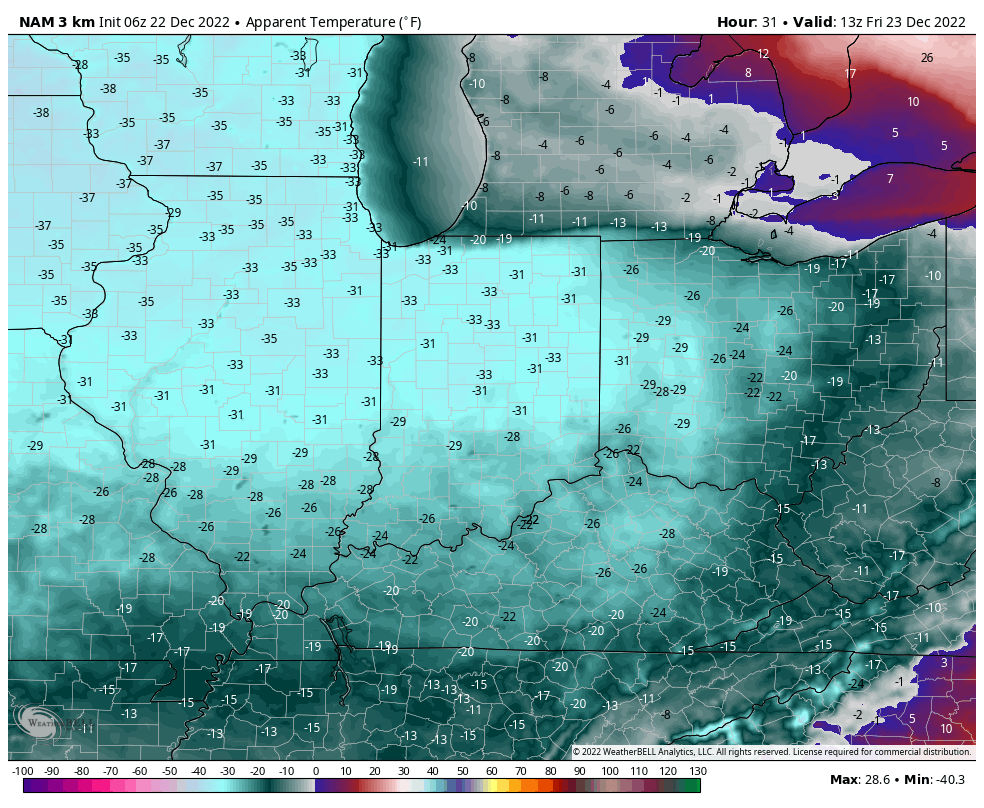
Temperatures: Falling from the upper 30s (Thursday afternoon) to 0° to 10° below zero (Friday morning).
Wind: NW 15-25 MPH, shifting to the WSW and increasing to 25-40 MPH with gusts to 50 MPH
Blowing/ Drifting: Severe
Pavement Impacts: Plowing and salting will be required throughout the region.
Summary: Light rain is overspreading central Indiana this morning as moisture is slowly pulled northward ahead of the approaching arctic cold front. That arctic front is still expected to plow across the state this afternoon (just after lunchtime across western IN, between 3p and 4p for Indianapolis, and by 7p – 8p for our far eastern IN neighbors). Once the front hits, you’ll notice a dramatic wind shift to the northwest and increase to 20-30 MPH with higher gusts, along with a temperature plummet. We’ll likely see temperatures fall more than 20° in less than 90 minutes once the arctic front passes.
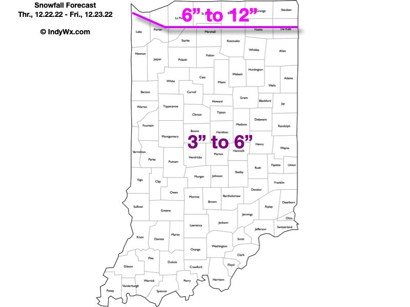
As all of this is taking shape, a wave of low pressure will move from southwest IN late afternoon into eastern MI by Friday morning. Long time Hoosiers know that’s a classic track to deposit a nice snowstorm around these parts. Rain will change to snow in the city around, or just after, 4p and we’ll notice the swath of snow growing in overall coverage and intensity as the low pressure system deepens. Periods of heavy snow can be expected at times tonight.
Meanwhile, winds will continue to increase to 25-35 MPH sustained with gusts to 50 MPH tonight, continuing through the day Friday and into the first portion of Christmas Eve morning. These persistent strong winds won’t only potentially lead to power outages, but continuous blowing and drifting issues through the aforementioned period. Blizzard and whiteout conditions will continue at times. Snow removal efforts will likely have to continue into Christmas Eve to account for the severe blowing and drifting on area roadways, especially north-south roadways. While the heavy snow will come to an end early Friday morning, light snow and blowing snow will persist through the day Friday and into early Christmas Eve morning.
Finally, the dangerous cold is going to be a big problem with this multi-faceted winter storm. After we fall to below zero Friday morning, highs on Friday likely won’t make it back much above 0°. Add in the wind and wind chill values of more than 30° below zero can be expected.
Confidence: High
Next Update: This evening (video discussion)