You must be logged in to view this content. Click Here to become a member of IndyWX.com for full access. Already a member of IndyWx.com All-Access? Log-in here.
Category: Autumn
Permanent link to this article: https://indywx.com/video-secondary-cold-front-moves-through-the-region-tonight/
Nov 15
VIDEO: Big Wind Machine Slowly Diminishes Overnight As Chilly Air Settles In; Looking Ahead Towards Thanksgiving…
You must be logged in to view this content. Click Here to become a member of IndyWX.com for full access. Already a member of IndyWx.com All-Access? Log-in here.
Permanent link to this article: https://indywx.com/video-big-wind-machine-slowly-diminishes-overnight-as-chilly-air-settles-in-looking-ahead-towards-thanksgiving/
Nov 14
VIDEO: Strong Fall Front Whips Across The State Tonight…
You must be logged in to view this content. Click Here to become a member of IndyWX.com for full access. Already a member of IndyWx.com All-Access? Log-in here.
Permanent link to this article: https://indywx.com/video-strong-fall-front-whips-across-the-state-tonight/
Nov 10
All Hope’s Lost For Colder Weather Around Thanksgiving? Not So Fast, My Friend…
Our long standing November Outlook was for a chilly first couple days of the month followed by a prolonged period of transitional weather that eventually gave way to more cold around Thanksgiving. Admittedly, we didn’t think the stretch of warmth we’re now exiting would be as significant. While on the surface the longer range doesn’t appear to offer up much hope for significant chill, we continue to keep a close eye on the potential of a more sustained chilly pattern developing by late month.
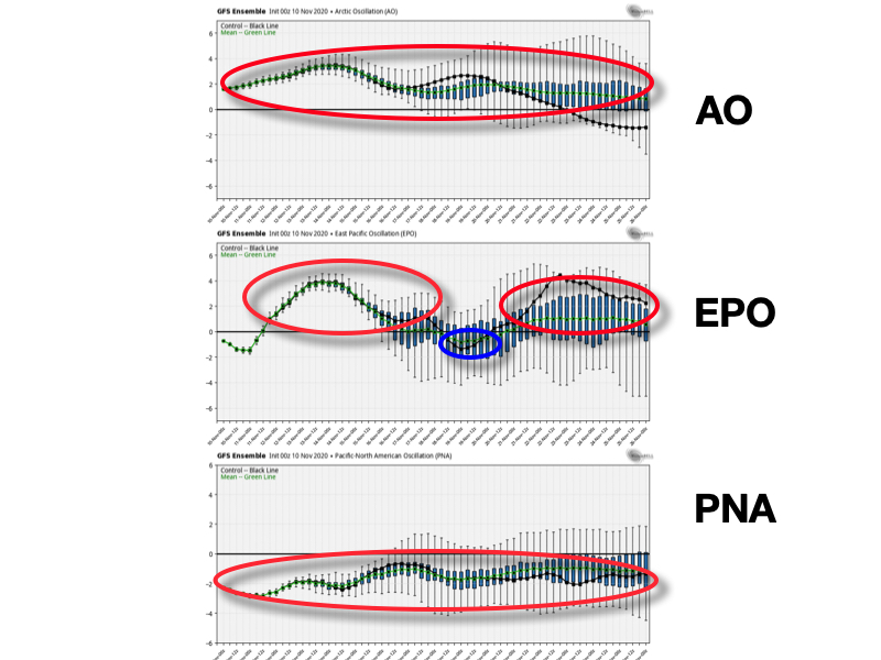
First, let’s take a look at the latest teleconnections:

As has been the case of late, these are mostly aligned (all with the exception of the EPO briefly) in a manner that will make it tough to drive any sort of sustained chill through the next couple of weeks.
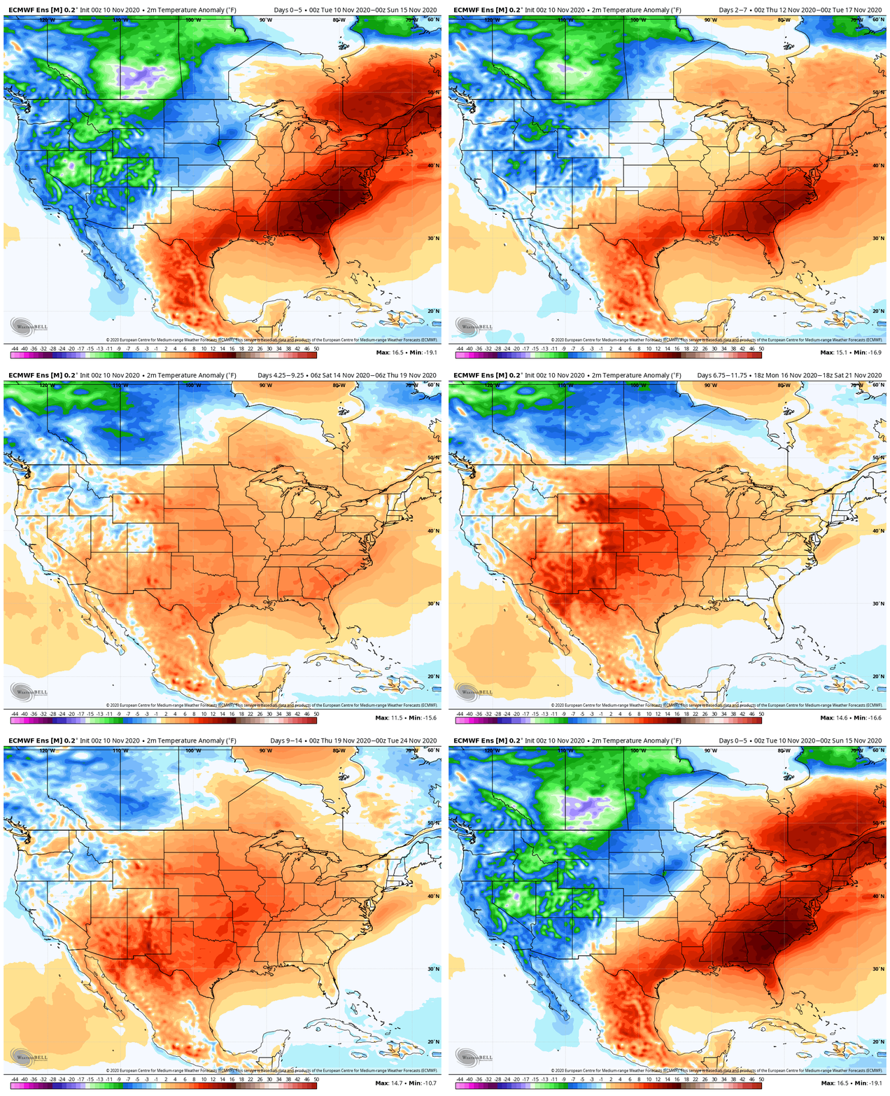
As such, the latest longer range data shows an overall seasonal to warmer than normal pattern continuing as Thanksgiving approaches, centered over the Plains.

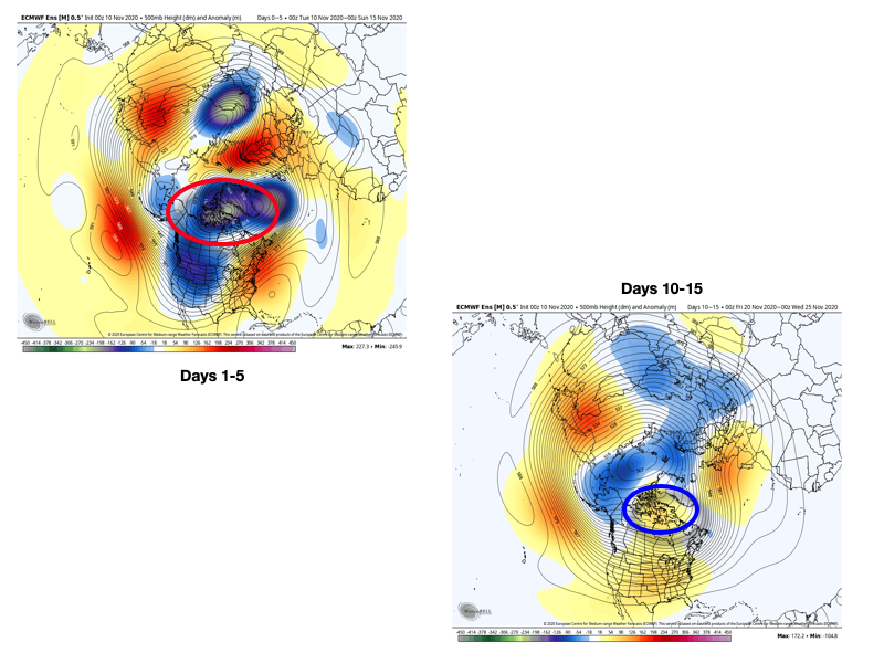
This is a bit intriguing as the model is “trying” to see cooler anomalies along the eastern seaboard in the Week 2 timeframe. What’s even more interesting is the higher heights in Canada that develop in the Day 10-15 time frame. Note the dramatic difference between now and then.

That was the basis of our late November forecast (high latitude blocking and subsequent negative AO developing that would force the colder air south). While the teleconnections don’t support that as of yet, one of two things will happen in the coming couple weeks: 1.) the teleconnections will have to adjust or 2.) the model will be incorrect in showing the Canadian ridge developing.
That brings us to the MJO. Just after the 15th, guidance takes things into Phase 2. That phase in November favors colder than normal weather across the eastern 1/3 of the country, including right here on the home front.


Perhaps the longer range European ensemble is beginning to see this and will expand the chill in the coming 10 days, or so. One thing’s for sure, we’ll be here to keep a close eye on the developments and update accordingly. From this distance, I wouldn’t throw in the towel on the potential of a colder pattern developing late month. I know we’re not.
More later this evening, including the daily video update that will take a closer look at rain and embedded thunder tonight.
Permanent link to this article: https://indywx.com/all-hopes-lost-for-colder-weather-around-thanksgiving-not-so-fast-my-friend/
Nov 09
VIDEO: Tracking (2) Cold Fronts In The Week Ahead…
You must be logged in to view this content. Click Here to become a member of IndyWX.com for full access. Already a member of IndyWx.com All-Access? Log-in here.
Permanent link to this article: https://indywx.com/video-tracking-2-cold-fronts-in-the-week-ahead/
