You must be logged in to view this content. Click Here to become a member of IndyWX.com for full access. Already a member of IndyWx.com All-Access? Log-in here.
Category: Autumn
Permanent link to this article: https://indywx.com/video-certainly-isnt-a-boring-pattern-to-close-november-and-open-december/
Nov 20
The Season’s First Accumulating Snow Event Arrives Tomorrow Night Across Northern Indiana…
You must be logged in to view this content. Click Here to become a member of IndyWX.com for full access. Already a member of IndyWx.com All-Access? Log-in here.
Permanent link to this article: https://indywx.com/the-seasons-first-accumulating-snow-event-arrives-tomorrow-night-across-northern-indiana/
Nov 20
Long Range Update: Closing Out Fall And Heading Into Meteorological Winter…
As we’re getting set to turn the page into a new season, modeling already agrees that the overall pattern is very much unlike the big “player” on the field (La Nina). While all Nina (as well as Nino and La Nada) events are different and unique, the “average” La Nina pattern is shown below:
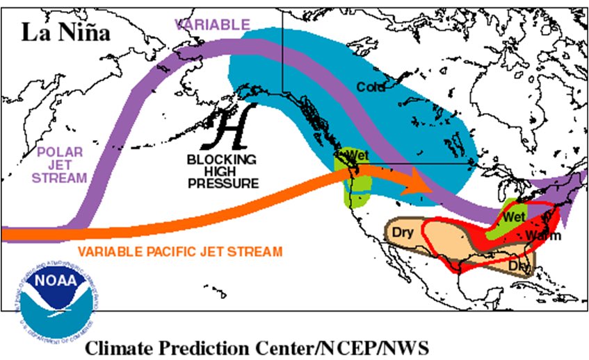
Note both the EPS and GEFS for early December are polar opposite of this traditional La Nina look:
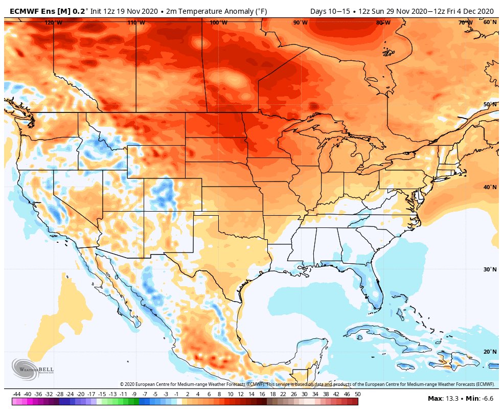
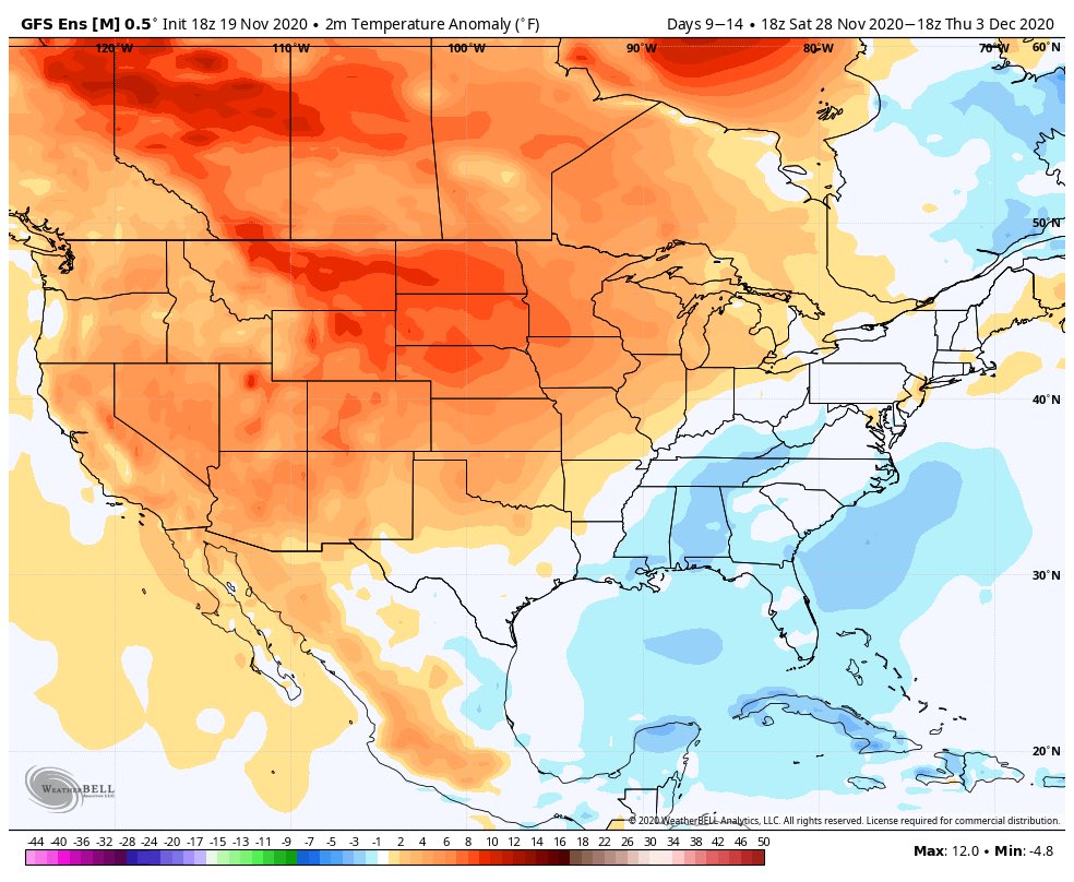
Before we look further at the various data, let’s review the latest teleconnection trends and MJO plots.
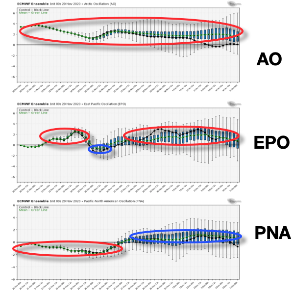
Teleconnections: In short, the consensus is it’ll be hard to drive any sort of sustained cold weather into early December. Note the AO is expected to run positive throughout the upcoming couple weeks, the EPO is mostly positive, as well. The one potential “fly in the ointment” that we’ll continue to keep a close eye on? The PNA and whether or not it continues to trend positive down the road.
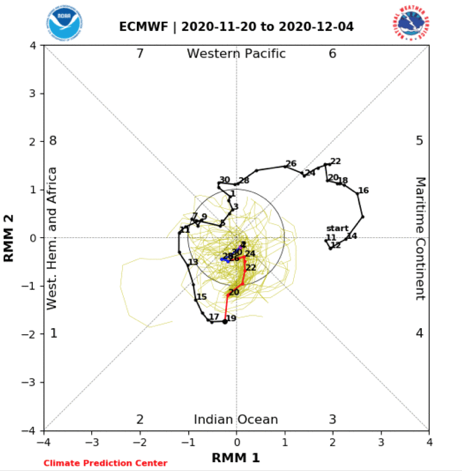
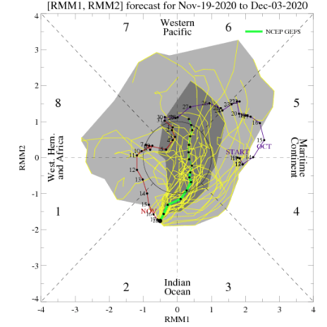
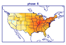
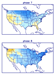
MJO: This is much more problematic as the data disagrees on what takes place down the road. The European products stall things in the null phase (meaning we need to pay more attention to the teleconnection drivers) while the American data seems to want to take things towards Phase 6 by early Dec. This is interesting on multiple fronts. Obviously having to do with the battle between the models, but also whether the amplitude continues down the road. If (big If) the American model wins out, it could mean we swing things into the colder phases towards mid-December. Again, this is a very low confidence forecast and will require a close eye as we move ahead.
Model Data over the next couple of weeks:
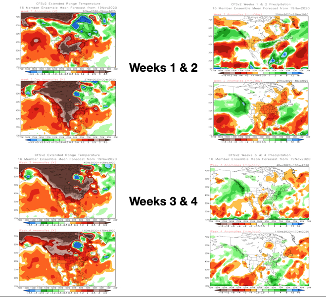
CFSv2 Weeklies- warmth dominates over the next few weeks. Note the model sees the wet pattern in the immediate term before drying us out Week 2. Eventually, the wet pattern is shown to return during the Weeks 3-4 time period.
JMA Weeklies- Similar story to the CFSv2 Weeklies above. Warmth dominates, but what we’ll need to look for is the possibility of the model trending cooler “underneath” with time as the warmth builds over the top. While not an overly cold pattern by any means, should this take place, all of the sudden a rather “boring” pattern from a wintry perspective can flip and become more interesting. Note the precipitation pattern is also similar: wet now, drier Week 2, and a return of the more active times Weeks 3-4.

European Weeklies- Not much difference from the other weekly products with a warm look, overall. Similar to the JMA, we’ll need to watch if the warmth continues to build in Canada which would likely result in cooling across a portion of the Lower 48 (most likely Southeast region first) with future updates.
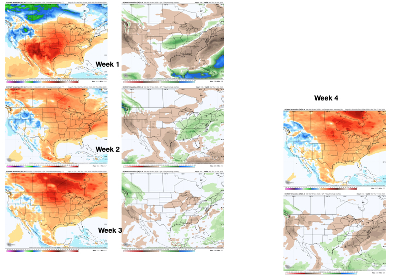
The overall consensus is it’ll be tough to get any sort of long-lasting well below normal airmass between now and Dec. 10. While it looks warmer than normal through the majority of the next couple of weeks, that’s not to say it’s a pattern without challenges, as pointed out above. (Heck, areas of northern IN may deal with wintry precipitation over the weekend). Of greatest interest, personally, is the PNA trend and watching the models “duke it out” with the MJO.
Permanent link to this article: https://indywx.com/long-range-update-closing-out-fall-and-heading-into-meteorological-winter/
Nov 19
VIDEO: Busy Time Of Things Into Thanksgiving Week; Looking At The Pattern Drivers Into Dec…
You must be logged in to view this content. Click Here to become a member of IndyWX.com for full access. Already a member of IndyWx.com All-Access? Log-in here.
Permanent link to this article: https://indywx.com/video-busy-time-of-things-into-thanksgiving-week-looking-at-the-pattern-drivers-into-dec/
Nov 18
Tracking Multiple Storm Systems Between Now And Month’s End…
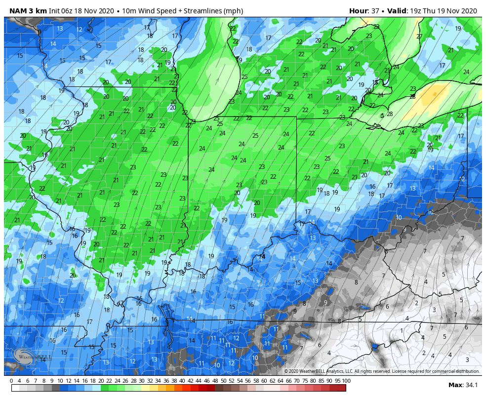
As Thanksgiving and the “official” kickoff to the holiday season nears, the weather pattern sure appears as if it’ll become a bit more hectic and busy in nature. In the short-term, we’re forecasting another significant wind event Thursday. While likely not to the magnitude of what we saw across central IN last Sunday, sustained southwest winds of 20-25 MPH will develop Thursday with gusts approaching 50 MPH.
That leads us to Friday and the upcoming weekend. While most of the day Friday will be rain-free, we’ll notice a lowering and thickening cloud deck by afternoon and evening and light rain will eventually follow. This has to do with a “wavy” frontal boundary that will be draped across the central Ohio Valley. It was only a couple of days ago where most modeling pegged this frontal boundary to lie across the southern Great Lakes region (which would’ve led to a warmer and drier weekend, locally). Alas, we can expect periods of light rain and chilly weather Saturday with heavier, steadier rain arriving Sunday as the cold front sweeps through the region. Drier and cooler air will then filter into the region as we progress through the early parts of Thanksgiving week, itself.
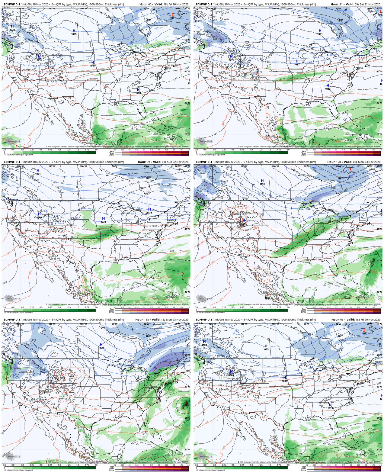
Model data agrees that between 1″ and 1.3″ of rain will fall across immediate central Indiana with this event (total between Friday night and Sunday). Officially, on a broader scale, we’ll forecast 0.75″ to 1.25″ with locally heavier amounts possible.

After a quieter couple of days to open Thanksgiving week, itself, we’re tracking 2 additional storms next week. The first will likely arrive Wednesday with gusty showers and blustery conditions.

The 2nd storm system will blow into town Friday and Saturday. The trade-off in between, if we’re lucky, will be a pleasant (seasonably cool and dry) Thanksgiving holiday.
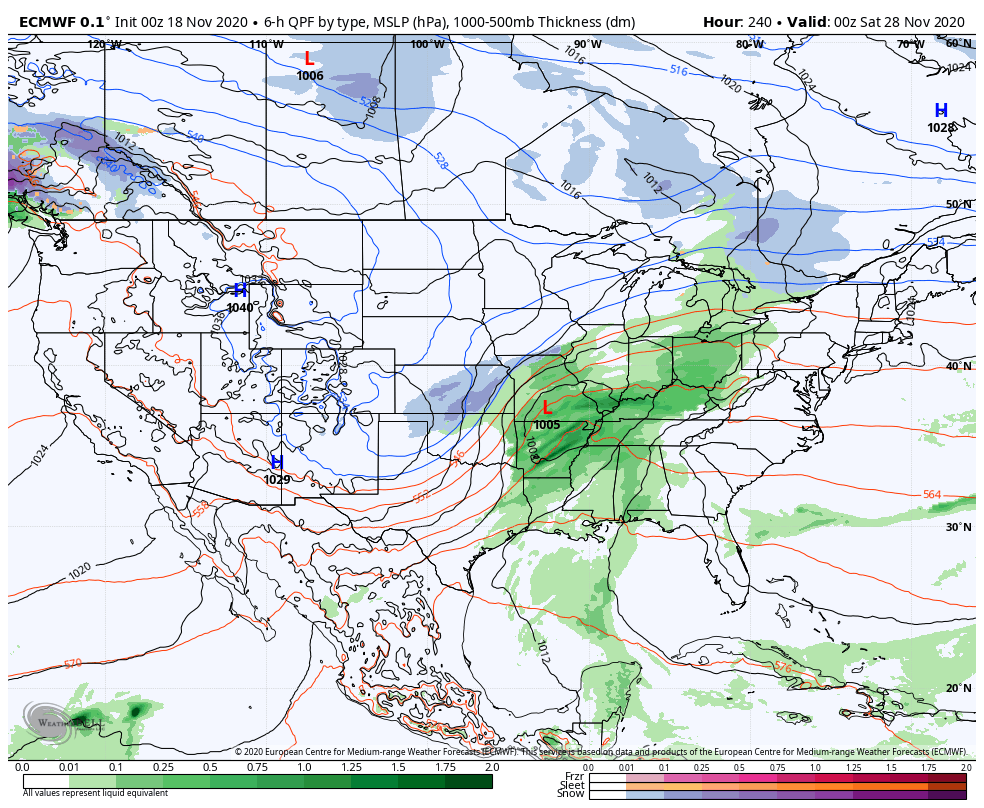
To no surprise, the European ensemble sees a wetter than normal close to the month upcoming, including a good chunk of the Ohio Valley, Southeast, and East Coast.

Permanent link to this article: https://indywx.com/tracking-multiple-storm-systems-between-now-and-months-end/
