Category: Autumn

More Great Weather Ahead…


Thr.

Fri.

Sat.

Sun.

Mon.

Tue.

Wed.

 Status-weather-clouds-icon

 Status-weather-clouds-icon

 Status-weather-clouds-icon

 Status-weather-showers-day-icon

 Status-weather-clouds-icon

 Status-weather-clouds-icon

 Status-weather-clouds-icon

47/ 70

49/ 73

54/ 81

56/ 75

51/ 69

49/ 70

47/ 70 

Dry Weather Continues…Our dry stretch will grow over the upcoming few days.  High pressure will remain in control of our weather and supply lots of sunshine.  Temperatures, though while moderating from the unseasonably cool levels we’ve experienced the past week, will remain below normal through the rest of the work week.  We’ll get one day of above normal warmth and that will come Saturday amidst breezy southwest winds and increasingly cloudy skies late.

Cold Front Moves Through…A cold front will move through the region Sunday.  While we don’t anticipate heavy rainfall, scattered showers and thunderstorms will enter the picture as early as Saturday night and continue into Sunday.

Back To Sunshine…Cooler air and dry skies return to kick off the new work week!  More ideal autumn weather is ahead in time for the official start of fall (we’ve been in meteorological fall since September 1st).

Upcoming 7-Day Precipitation Forecast:

  • 7-Day Rainfall Forecast: 0.25″ – 0.50″
  • 7-Day Snowfall Forecast: 0.00″

Permanent link to this article: https://indywx.com/more-great-weather-ahead/

Sun-Filled Weather Until Sunday…

Wed. Thr. Fri. Sat. Sun. Mon. Tue.               45/ 69 49/ 71 49/ 73 56/ 82 58/ 78 52/ 72 48/ 63  MO Storms…

You must be logged in to view this content. Click Here to become a member of IndyWX.com for full access.  Already a member of IndyWx.com All-Access?  Log-in here.

Permanent link to this article: https://indywx.com/sun-filled-weather-until-sunday/

Catching Up On A Tuesday Evening…

Several interesting weather items are on the docket and each will have to be dealt with as they come over the course of the upcoming 7 days.  Some of the headlines include a brief warm-up Saturday, weekend rain that could include a tropical connection Sunday, and another big shot of October-like chill next week.

While we have a few more days of below normal temperatures in front of us, we eye at least one day where temperatures will manage to climb above normal and that’s Saturday.  All indications still suggest we’ll be very close, if not a degree or two higher, than the 80 degree mark along with a nice southwest air flow in place Saturday.  All-in-all, it’ll be a great day to take care of any early-autumn yard work that’s needing to get done.

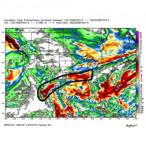
Changes brew Sunday as a cold front draws near.  This is where questions lie and they actually have to do with Tropical Storm Odile (currently all the way to our southwest over the central Baja California peninsula region).  Odilemoisture

While the GFS and European forecast models still aren’t interested in “welcoming” Odile’s moisture into the region, we note the Canadian model does suggest some tropical moisture, courtesy of Odile, gets entangled along the front Sunday.  We’ll continue to keep a close eye on things and monitor the forecast data accordingly moving forward through the back half of the work week.


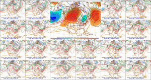
The other item of interest has to do with yet another big blast of autumn air that will have things feeling very much like October around these parts come early next week.  The above average temperatures Saturday will hang around just for the day as yet another unseasonably chilly air mass moves into the area Monday into Tuesday of next week as a significant trough develops over the east with an impressive western ridge in place.  f156


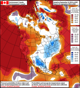
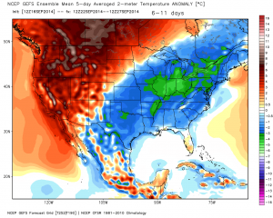
Note the GEFS and Canadian show the return of the unseasonable chill next week.  Keep those jackets handy.  Early indications would suggest this type air mass is plenty capable of highs in the upper 50s/ lower 60s and overnight lows in the upper 30s/ lower 40s during the height of the chill (most likely Tuesday).  Stay tuned…

2014091600_054@007_E1_north@america_I_NAEFS@TEMPERATURE_anomaly@probability@combined@week2_198gefs_t2anom_by5_conus_45


Permanent link to this article: https://indywx.com/catching-up-on-a-tuesday-evening/

More Unseasonably Cool Fall Air…

Tue.

Wed.

Thr.

Fri.

Sat.

Sun.

Mon.

 Status-weather-clouds-icon

 Status-weather-clouds-icon

 Status-weather-clouds-icon

 Status-weather-clouds-icon

 Status-weather-clouds-icon

 Status-weather-showers-day-icon

 Status-weather-clouds-icon

52/ 65

46/ 69

47/ 70

49/ 73

54/ 82

58/ 75

46/ 65 

Brightening Skies Through The Day…The morning is starting off on a gloomy note, but skies will turn increasingly sunny as we progress deeper into the day.  Cool, crisp fall air will remain in place as temperatures only top out in the middle 60s- a whopping 12-14 degrees below average.  Another cool night is on tap tonight with lows in the middle 40s.

Nice Stretch Of Dry Weather…We’ll hold on to dry and sunny conditions for mid week into the first half of the weekend.  While temperatures will moderate each day, it’s not until Saturday when temperatures should reach above normal levels.  Southwest winds will blow a warmer, more humid brand of air northbound Saturday out ahead of our next storm system.

Sunday Storms; Another Cool Down…A cold front will move through the region Sunday with showers and thunderstorms.  Another punch of unseasonably cool air will blow into town just in time to welcome in the new work week!

7-Day Precipitation Forecast:

  • 7-Day Rainfall Forecast: 0.50″
  • 7-Day Snowfall Forecast: 0.00″
hrrr_cloud_indy_14

Forecast cloud cover shows nearly 0% later this evening- a good indication of the increasingly sunny sky condition we should note later today.

Permanent link to this article: https://indywx.com/more-unseasonably-cool-fall-air/

Colts Forecast: Showers; Embedded Thunder Around…

A weak frontal boundary will slip into central Indiana this evening. Increasingly cloudy skies will result and scattered light showers/ embedded thunderstorms will dot the local landscape this evening. The…

You must be logged in to view this content. Click Here to become a member of IndyWX.com for full access.  Already a member of IndyWx.com All-Access?  Log-in here.

Permanent link to this article: https://indywx.com/colts-forecast-showers-embedded-thunder-around/