Category: Autumn

Weekly Outlook: Big Weather Changes…

October, month-to-date, shows a reflection of cool anomalies across the Great Lakes region and wetter than normal across the central and Tennessee Valley. The week will get off to an…

You must be logged in to view this content. Click Here to become a member of IndyWX.com for full access.  Already a member of IndyWx.com All-Access?  Log-in here.

Permanent link to this article: https://indywx.com/weekly-outlook-big-weather-changes/

Short-Term Headline Is The Warmth…

We’ll be back later this afternoon to discuss the big late week chill, but want to focus on the warmth of early week this morning. Today will be gorgeous- wall-to-wall…

You must be logged in to view this content. Click Here to become a member of IndyWX.com for full access.  Already a member of IndyWx.com All-Access?  Log-in here.

Permanent link to this article: https://indywx.com/short-term-headline-is-the-warmth/

The Ups And Downs Of Autumn…

It simply doesn’t get much better than this!  Wall-to-wall sunshine and temperatures in the lower to middle 70s across central Indiana this afternoon…  If you aren’t outside now, we are making it mandatory to get outside upon reading this!  🙂  Enjoy, as the ups and downs of autumn will send us in an opposite direction late in the upcoming week.

Forecast models are coming into better agreement on the evolution of things heading into next weekend.  While there are still a couple of important differences between the GFS and European, we’re growing increasingly confident on a much colder feel next weekend.

Note the latest GFS operational run stacked atop individual ensemble members.  Needless to say, there’s ensemble support and leads to a higher confidence forecast in the mid range of a deep trough carving itself out across the Mid West and East.  Unseasonably cold air would be associated with this.

GFS


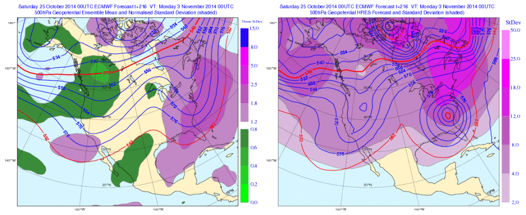
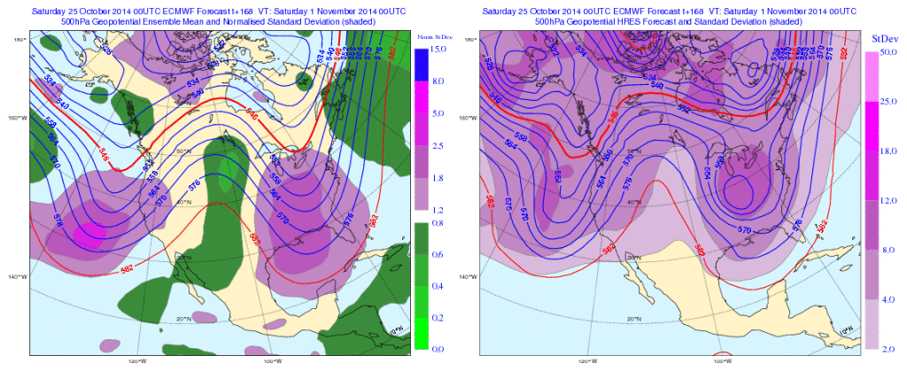
Meanwhile, the European model is more extreme, suggesting a cut off feature develops across the southeast before helping spawn a Nor Easter and leading to high ground accumulating snows from the southern Appalachians northeast along the spine of the mountains.

Again, there’s ensemble support (left) to go with the operational run (right).
EC1

EC2

Whether or not we get some sort of cut off low pressure system to really dig in and help generate high ground snow is up for debate and will be the focal point for many for the upcoming week.

Back here on the home front we’re becoming increasingly confident on the first push of wintry type air here next weekend and timing will have to be fine tuned as we move forward, including the all-important Halloween forecast.  The type air mass moving in will most likely put an end to the growing season across these parts as it’s likely capable of producing multiple below freezing nights.

Much more in the days ahead!  In the meantime, enjoy what we have in front of us now!

Permanent link to this article: https://indywx.com/the-ups-and-downs-of-autumn/

Beautiful Weekend, But Major Changes Waiting On Deck…

Sat.

Sun.

Mon.

Tue.

Wed.

Thr.

Halloween

 Status-weather-clouds-icon

 Status-weather-clouds-icon

 Status-weather-clouds-icon

 Status-weather-storm-night-icon

 Status-weather-clouds-icon

 Status-weather-clouds-icon

 Status-weather-showers-scattered-icon

53/ 72

44/ 67

53/ 75

47/ 68

42/ 55

40/ 54

39/ 49 

Beautiful Autumn Weekend…Early morning clouds quickly burned off and gave way towards a mostly sunny to partly cloudy sky by late morning.  That sunny theme will remain as we roll into the afternoon and the second half of the weekend, as well.  Highs this afternoon will reach into the lower 70s before a push of slightly cooler air moves in tonight that will keep us in the 60s for highs Sunday.

Warm Open To The Work Week Before Big Changes…We’ll open up our new work week with lots of sunshine and unseasonably warm (almost balmy) temperatures.  We think highs Monday afternoon make it all the way into the middle 70s.

A strong cold front has aim on the area Tuesday and will include showers and thunderstorms as the front passes.  Much cooler air will flow into the area behind the boundary for mid week.

As we get into the latter portion of the week, forecast models have a couple of different scenarios, but the common theme is a chilly one.  Whether or not the chilly air includes precipitation is yet to be determined, but we’re siding more towards the European solution for now and building light rain into our Halloween forecast as unseasonably cold air pours south.

Upcoming 7-Day Precipitation Forecast:

  • 7-Day Rainfall Forecast: 0.50″ – 0.75″
  • 7-Day Snowfall Forecast: 0.00″

Permanent link to this article: https://indywx.com/beautiful-weekend-but-major-changes-waiting-on-deck/

Another Frosty Start…

Thr.

Fri.

Sat.

Sun.

Mon.

Tue.

Wed.

 Status-weather-clouds-icon

 Status-weather-showers-day-icon

 Status-weather-showers-day-icon

 Status-weather-clouds-icon

 Status-weather-clouds-icon

 Status-weather-showers-scattered-icon

 Status-weather-clouds-icon

38/ 60

47/ 64

49/ 71

44/ 67

52/ 75

53/ 72

42/ 56 

Bundle Up…It’s another chilly and frosty start to the day and patchy fog has developed across portions of central Indiana this morning.  Plan to leave a little extra time on your way to work or school to account for this.  Otherwise, the first half of the day will feature bright sunshine (fog should burn off quickly) before clouds begin to increase this afternoon and evening.

More Bark Than Bite…A couple waves of very light precipitation will move through central Indiana Friday morning and again Saturday morning.  With a very dry air mass in place, this should be scattered and very light in nature (some won’t get wet at all).  Temperatures will be very mild Saturday before a brief Sunday “speed bump,” as a frontal boundary moves through.

Warm Open To The Work Week…A pronounced southwesterly flow will be in place ahead of our next cold front that appears to have a Tuesday focus.  Monday and Tuesday will feature unseasonably warm temperatures.  We’ll note our best chance of widespread measurable rain of the forecast period on Tuesday.  Cooler air will flow back into the area on gusty northwest winds Tuesday night.

Upcoming 7-Day Precipitation Forecast:

  • 7-Day Rainfall Forecast: 0.50″
  • 7-Day Snowfall Forecast: 0.00″

Permanent link to this article: https://indywx.com/another-frosty-start/