Category: Arctic Cold

Snowy Pattern Continues…

Considering we’re only a third of the way through December, we’re certainly running “snowier” than normal at this very early stage in the game.  As we look ahead at the upcoming 10 days, or so, we see this snowier than normal pattern continuing with multiple systems to contend with over the course of the upcoming couple weeks.  Up next will be the threat of some light snow showers and flurries with reinforcing arctic air Wednesday PM.  Nothing significant is anticipated here on Wednesday, accumulation-wise, but snow showers will blow through the area Wednesday afternoon.  The latest high-resolution NAM shows this well.

hires_ref_indy_37


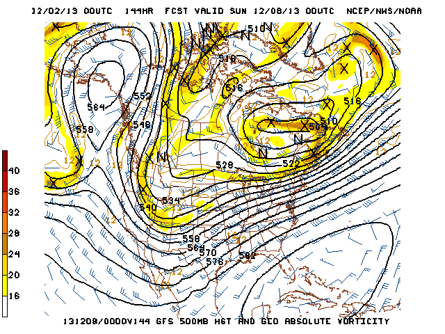
Then our attention turns to a developing winter storm for the weekend. We think clouds increase Friday and snow develops Friday night into early Saturday.  Here’s a look at the latest GFS forecast model, valid Friday night.

gfs_ptype_slp_east_17


Fast forward that to Saturday morning and snow grows heavier…

gfs_ptype_slp_east_18


The GFS suggests a weak surface low tracks into eastern Ohio with backlash snow showers and embedded squalls continuing here Saturday night into Sunday.

gfs_ptype_slp_east_20


It’s important to remember that we’re still a few days out from this event and I can guarantee you things will change as we go through the course of the upcoming few days that will require us to do some adjusting to our forecast Friday-Sunday.  That said, at this early stage in the game, unlike with our last storm, I’d favor areas from IND and points north as the place where heavier snow falls this go around.

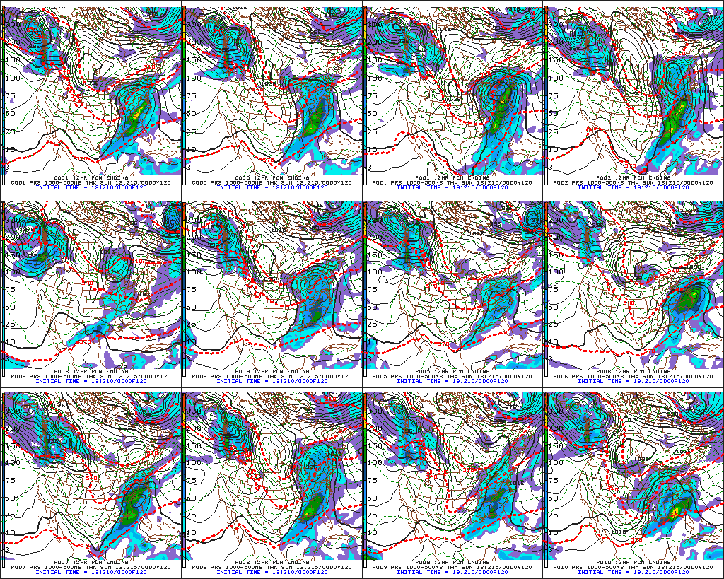
Latest GFS ensembles suggest something similar to the operational run shown above with one low tracking into the eastern Ohio Valley as another coastal low develops.

f120

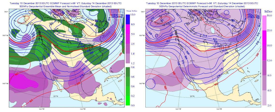
The European ensembles provide an “intriguing” look for an Ohio Valley winter weather event this weekend, as well.

Geopotential32at32500hPa_North32America_96


A couple of additional items to consider at this early juncture- this will be a fast moving winter storm so that will have an impact on snowfall accumulation.  Additionally, there’s also the chance enough warm air aloft advects (WAA or warm air advection) into the southern portions of the region to result in “mixing” issues (i.e. sleet and freezing rain).  In the primarily “snow zone” Friday night-Saturday (again, we’re currently targeting IND and points north for the snow zone) several inches of snow could accumulate.

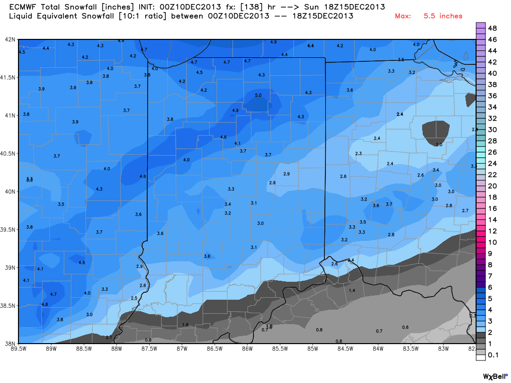
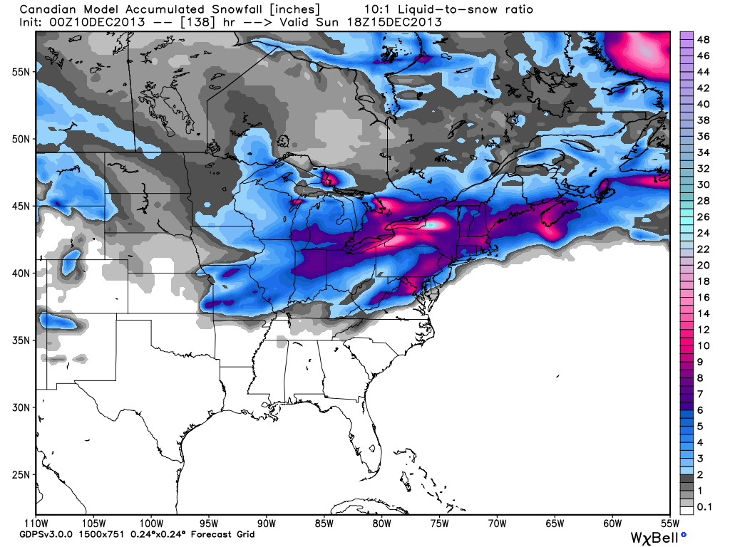
Here’s an early look at what the latest mid-range forecast models are seeing in terms of potential accumulations with this event.  Top to bottom: ECMWF, GFS, and Canadian.  Stay tuned, we’ll have another update later!  Enjoy your day!

ECMWFGFScmc_snow_acc_east_24

Permanent link to this article: https://indywx.com/snowy-pattern-continues/

Monday Morning Weather Rambles…

1.)  Light freezing rain and freezing drizzle led to numerous reports of a light glaze and associated very hazardous travel across central Indiana overnight.  With temperatures remaining below freezing today,…

You must be logged in to view this content. Click Here to become a member of IndyWX.com for full access.  Already a member of IndyWx.com All-Access?  Log-in here.

Permanent link to this article: https://indywx.com/monday-morning-weather-rambles/

A Closer Look At Two Winter Weather Events.

Your updated, custom-built, Thursday video forecast can be found to the right of this post in the video player.  We typically update our video forecast during the evening.

Good Morning and happy Thursday!  We continue to monitor the latest data for our upcoming winter weather events.  It’s a busy time of things and by the looks of the overall pattern, I’ll have to stock up on the coffee for the weeks ahead.  Quite honestly, a very cold and snowy pattern appears to be setting up shop now through the end of the month.  Anyone dreaming of a white Christmas? 😉

Here are some quick bullet points for the upcoming few days:

  • Snow/ sleet overspreads the region this evening
  • (2) waves of snow/ sleet move through the region between this evening and Friday
  • Saturday will be a very cold and dry day
  • Renewed snow and potentially freezing drizzle move in Sunday
  • We continue to forecast a total of 3-6″ of snow between tonight and Monday morning

Latest forecast models continue to suggest temperatures fall through the day with a mixture of snow and sleet overspreading the region as early as 3-5pm from southwest to northeast.  We anticipate a rather rapid transition from sleet to snow, especially from IND and points north.  Here’s a look at the latest HRRR simulated radar data, valid tonight at 6 o’clock:

hrrr_ref_indy_15

Here’s a look at the GFS model.  (We think this particular model has a much better handle on things now that we’re closer to the event).  Note the “waves” of wintry precipitation forecast and we agree with this.  Wave #1 arrives for the evening rush with wave #2 arriving Friday morning into the afternoon.

GFS1GFS2GFS3

Additionally, after a very cold and dry Saturday, renewed accumulating snow will overspread the region Sunday, potentially ending as a mixture of light freezing rain or freezing drizzle atop the fresh snow Sunday afternoon.

GFS4GFS5

Permanent link to this article: https://indywx.com/a-closer-look-at-two-winter-weather-events/

Wednesday Morning Weather Rambles…

1.) Fog will hang tough this morning, but strong southerly winds will blow this afternoon and help the fog burn off.  2.) With the cold and snow talk ahead, be…

You must be logged in to view this content. Click Here to become a member of IndyWX.com for full access.  Already a member of IndyWx.com All-Access?  Log-in here.

Permanent link to this article: https://indywx.com/wednesday-morning-weather-rambles/

Potential Long Duration Winter Event Looming…

Your complete 7-Day IndyWx.com forecast can be found in the video player to the right of this post.

Before we begin to discuss the potential wintry mischief ahead for late week, it’s important to stress that there are still several unanswered questions out there that will have to be ironed out with time as we go through the next couple of days.  That said, the latest data continues to suggest the potential is there for a rather prolonged, multi-day, winter weather event looming.  This won’t come from some sort of powerhouse storm system, but instead multiple waves of energy (low pressure) moving along a pressing arctic boundary.  The continued “curious” item here is the interaction with the arctic boundary’s progress south and east and the resistance that will be put forth from the southeast ridge.

The latest 500mb pattern off the 0z run of the GFS forecast model has “trouble” written all over it and we must keep a close eye on things as we move forward the next couple of days.  Additional model data from the European forecast model and Canadian are also suggesting fun times ahead.

gfs_namer_144_500_vort_ht_s

This image is valid Saturday evening and shows a couple of important items- the southeast ridge and the associated fight it’ll put up with the pressing arctic front, as well as “renewed” energy organizing across the Four Corners region, organizing before a track northeast.

The way we currently see things panning out would suggest the threat of light accumulating snow is on the table late Thursday night through Friday followed by a dry and cold day Saturday. That said, as shown above, renewed energy will move northeast the second half of the weekend into early next week and be responsible for spreading moisture back over what will be an unseasonably cold air mass in place, certainly one conducive for wintry precipitation.

It’s important to note that this isn’t just a snow event, but some places of the immediate coverage area (central Indiana, in particular) could experience an icy mixture of sleet and freezing rain, as well.  It’s far too early to talk about any sort of storm total accumulations as these type “overrunning” events can surprise…  That said, we are gaining confidence on “part 1″ of this event providing light accumulating snow for most of central Indiana Friday- light meaning less than 3”.  Additional accumulation of wintry precipitation would occur with “part 2” of this event during the back half of the weekend.

Again, it’ll be crucial to keep up to date with the latest forecasts and developments as things become clearer as we move forward.  As of now, keep a mental note in the back of your mind that the possibility is there for accumulating snow late Thursday into Friday, as well as later in the weekend…

Permanent link to this article: https://indywx.com/potential-long-duration-winter-event-looming/