Category: Arctic Cold

Have To Love “Over-Achieving” Clippers…

Good Morning, Hoosiers!  We’re awaking to a snowy commute, as promised, but our little clipper could certainly be called an “over-achiever.” We’re receiving many reports of snowfall amounts of 1.5″…

You must be logged in to view this content. Click Here to become a member of IndyWX.com for full access.  Already a member of IndyWx.com All-Access?  Log-in here.

Permanent link to this article: https://indywx.com/have-to-love-over-achieving-clippers/

Tracking Two Light Snow Producers

Following on the heels of another early winter weather maker, we’re tracking renewed cold blowing into the region and two light snow producers the next couple of days.  The first clipper system will likely deliver some light snow accumulations (generally 1″, or less) tonight into the wee morning hours Monday.  The latest short-term, high-resolution, model data is picking up on this nicely.  While we’re not looking at significant snowfall, it’ll be just enough to lead to a slick Monday morning commute for some, especially from the city and northern ‘burbs.

Here’s a look at the simulated radar valid for this evening at 10 o’clock.  Light snow is spreading back into central Indiana.

HRRR1

Additionally, we’ll keep an eye on yet another fast-moving clipper Monday night and early Tuesday that will also have the potential of dropping a quick light accumulating snow (again, most likely 1″ or less).  All-in-all, we’re still locking tightly into Old Man Winter’s grip the next few days.

Permanent link to this article: https://indywx.com/tracking-two-light-snow-producers/

Old Man Winter Jabbing Now, But Is The Knock-Out Punch Coming?

Before we discuss what may lie ahead closer to Christmas, our going forecast for Friday night and Saturday’s snow storm hasn’t change…4-5″ for the greater Indianapolis region by late Saturday morning.

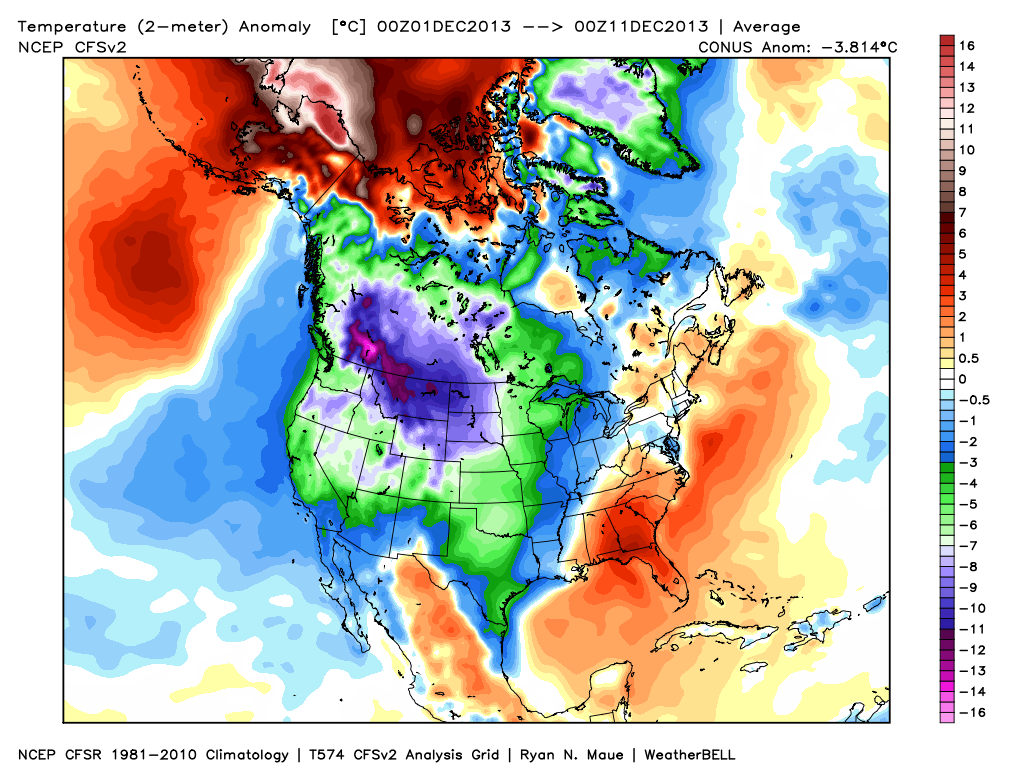
Since really back in the middle of October we noted a distinct pattern change that has resulted in a colder than normal regime around these parts ever since.  As we look ahead, there really aren’t any indicators that would suggest we’ll deal with warmer than normal air for any period of significant time through the remainder of the year.  Furthermore, there are multiple computer models hinting that we’ll have to deal with a significant winter storm and potentially a shot of brutal cold as we rumble closer to the busy Christmas week.

It’s very important to note that we still have several days to watch the goings on for Christmas week, but the stage has at least been set for the possibility of a storm of “importance” being around the region as we near that particular time period.

Confidence is growing on brutal cold (most likely record-breaking) initially dumping into the Plains states towards the latter portion of next week.  With time, we think this cold slugs it’s way east.  Before the arctic intrusion gains control of the Mid West and Ohio Valley, we think this is the area that stands the greatest chance of dealing with a major winter storm.  We have strong ensemble support (pictured below) of the evolution of the overall pattern, but we caution that the precise details will have to be ironed out.

Ensemble1Ensemble2Ensemble3

The “sensible” weather that would ensue here across central Indiana could vary wildly from a significant full-blown winter storm with all of the precipitation falling in the form of a wintry variety (i.e. snow, sleet, freezing rain) to a situation that features a western track with briefly milder air surging north into portions of the region and leading to a rain-to-snow situation.  The accumulation ideas would swing from a significant, plowable, snow storm to as little as a coating with arctic air blowing in behind the rain to snow scenario.

At the end of the day right now we’re confident on two things: 1.) a major winter storm around the Mid West/ Ohio Valley as we near Christmas week and 2.) brutal arctic air swinging into the area around Christmas.  Questions will have to be answered as we move ahead to determine the precise precipitation amounts and type.

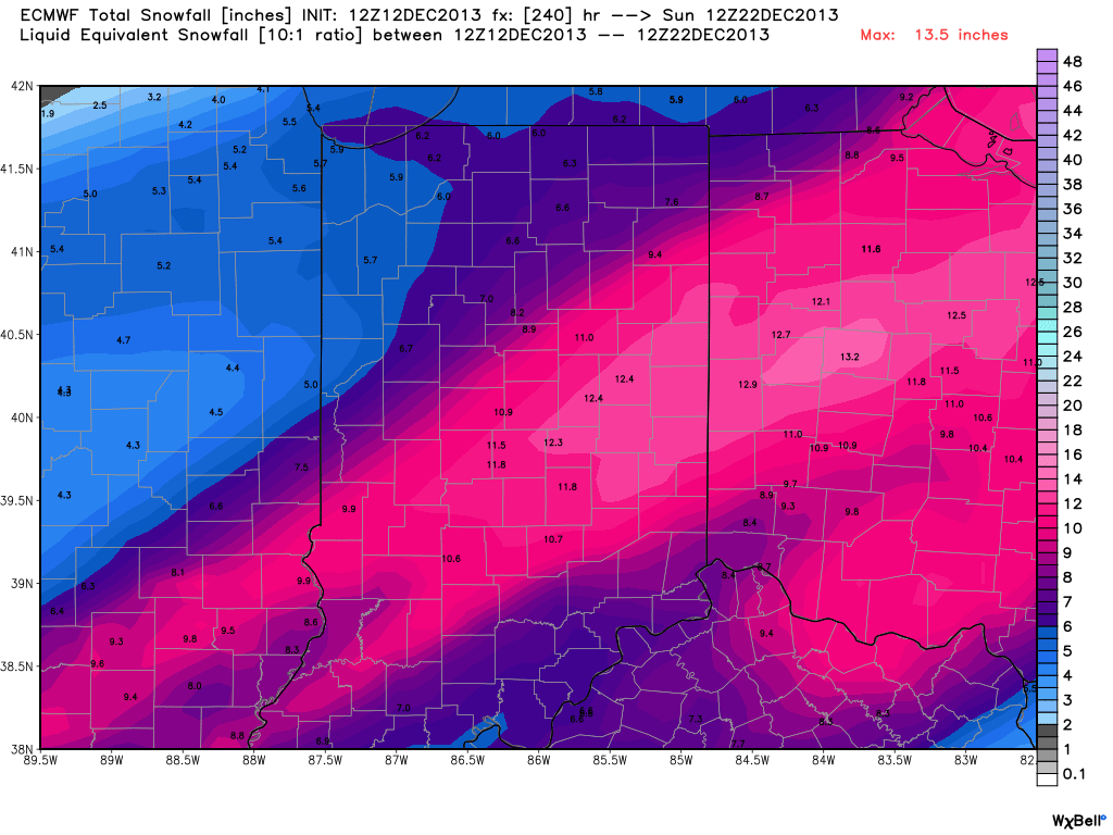
In closing, just for fun, we thought we’d provide a look at the latest European forecast model data.  Here’s a look at the upcoming 10 day European model snowfall forecast.  Of course, these amounts account for the 4-5″ expected here tomorrow night and Saturday,  but (2) additional systems also add to the potential growing snow pack…a clipper system Monday and the “more important” system next weekend.  Stay tuned.

Euro1

Permanent link to this article: https://indywx.com/old-man-winter-jabbing-now-but-is-the-knock-out-punch-coming/

Snow Talk And A Look Ahead Towards Christmas Week…

Latest data in house still suggests a plowable snow is ahead for most of central Indiana this weekend.  We think wintry precipitation expands northeast to encompass all of the region between 7pm-9pm Friday evening (southwest to northeast).  This wintry precipitation still appears to take the form of all snow for IND and points north, but we caution that south-central Indiana communities will have to deal with a mixed bag of precipitation, including sleet and perhaps some freezing rain along with the snow.  The primary snow zone will have no trouble seeing snow amounts of 4-5 inches, but for south-central Indiana neighborhoods, snowfall accumulations appear to be closer to 2 inches, with additional accumulations of sleet also possible.  Needless to say, we feel pretty good about our initial snowfall forecast posted last night in our 7-Day forecast video (always available to the right of these posts in the video player).  The limiting factor, in our opinion, of even higher snowfall totals will be due to the speed of the system.  We think this is primarily a quick 6-8 hour “thump and go” type snow storm followed by some lingering light snow/ snow showers and gusty winds Saturday PM.  The sunshine returns for Sunday along with another surge of bitterly cold air with highs in the 20s.

Friday night-Saturday Snow Storm Highlights:

  • Wintry precipitation arrives between 7p-9p Friday across central Indiana.
  • Primarily all snow from Indianapolis and points north
  • Mixed precipitation south of IND will include sleet and freezing rain
  • Snowfall accumulations of around 2″ south-central Indiana, increasing to 4-5″ amounts along and north of the I-70 corridor.
  • Accumulating snow tapers off late Saturday morning.

Our attention then turns to what may lie ahead Christmas week.  After the chance of some brief “relaxation” from the current bitterly cold pattern, we look to reload the cold with authority around Christmas week.  In fact, if latest data comes to fruition, the current cold would pale in comparison to what lies ahead.  Additionally, a rather significant storm system could precede the arctic blast.  It’s far too early to talk specifics on precipitation type or amounts, but don’t be surprised if a storm of “significance” is on the maps as we approach Christmas week…

The latest ensemble plot from the GFS and European (below) agree on first class cross-polar flow setting up shop, which will help refrigerate the Lower 48 with some seriously bitter air just in time for Christmas.  Stay tuned…

test8

Permanent link to this article: https://indywx.com/snow-talk-and-a-look-ahead-towards-christmas-week/

What A Difference A Year Makes!

Our colder than normal pattern has really been in place since mid October.  Looking ahead, despite some potential brief “relaxation” from the cold a few days next week, the mid to long range pattern continues to look colder than normal.  Here’s a look at December so far, temperature-wise.  Note the presence of the southeast ridge keeping that particular portion of the lower 48 warmer than normal, so far.  Everywhere else, the freezer door has been left open!

4

What a difference a year makes, snow-wise, as well!  Here’s a look at the snow cover on this date last year compared to present.  Amazingly, this year, nearly 64% of the country is snow covered compared to 31% on this date last year.

The combination of more than normal snow and colder air for the majority of the country can be traced back to the expanding snow pack across Canada earlier this fall.  Now, the cold and snow are essentially in “feed back” mode with one another, as the overall pattern ahead is one that’s plenty cold…and snowy.

21

Permanent link to this article: https://indywx.com/what-a-difference-a-year-makes/