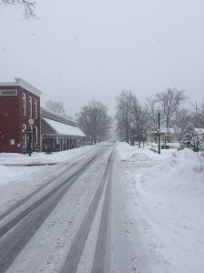
It was a record snowfall officially at IND where a storm total of 7.9″ was recorded (5.9″ accumulated since midnight). Many other 8″ type amounts are common throughout the heart of central Indiana- including right here at the IndyWx.com HQ. Yours truly ventured out through the village of Zionsville this afternoon. Simply beautiful!

We have a busy weather week upcoming and wanted to touch base on a few items of note:
1.) Freezing rain and potential slick travel will be possible very late Monday night into Tuesday morning. Moisture will attack from the southwest and run into an impressive snowpack currently in place across central Indiana. Despite warmer air moving in aloft, surface temperatures will remain cold enough through late Tuesday morning to allow precipitation to fall in the form of sleet and freezing rain Tuesday morning. It appears as if enough freezing rain could accumulate to result in slick travel throughout the region. While temperatures will “warm” into the lower 40s Tuesday afternoon, this is a far cry from the lower 50s modeling tried to suggest a few days ago. Furthermore, cold air will quickly rush back in here Tuesday night into Wednesday morning.
2.) Accumulating snow threat for the southern half of the state Wednesday into Thursday. Additional “energy” will round the base of a digging trough over the southern and central Plains states Wednesday. This will help ignite a surface low along the front and temporarily lead to the front stalling out just to our south and east. It’ll be close as to just how far north the accumulating snow shield makes it across southern and central Indiana, but will require a close eye in the coming day or two. We note some of our more reliable modeling placing central and southern portions of the state “under fire” for additional accumulating snow.
3.) Serious and potentially record cold returns this week. Yet ANOTHER blast of bitterly cold air will plunge into the area Wednesday night into Thursday. With snow on the ground, it’s possible this direct discharge of arctic air is even colder than what some data might suggest at this time. As it is already, we think some central Hoosier neighborhoods deal with sub-zero air in the Thursday/ Friday morning time frame. Thursday’s high will only manage to climb into the teens across the region. (Keep in mind the average low is 28 and average high is 45). Just amazing stuff!


