Category: Arctic Cold

Warm Up Coming…

After a long and cold winter, many are excited about hearing of the prospects of a warm up and first true taste of spring.

While the European data has totally bought in to the impressive “spring fling” next week, the GFS isn’t as excited of the potentially warmer times.  Case in point, the GFS and European couldn’t be in more different camps for mid and late next week.  Where the GFS has low/ mid 40s for highs the European has low/ mid 60s for highs.  What’s 20 degrees amongst friends?!

Wild model swings and disagreements are common when pattern changes are taking place.   While we might not get as warm as the Euro. would imply, it’s a safe bet we’ll be considerably warmer than the chilly GFS readings.

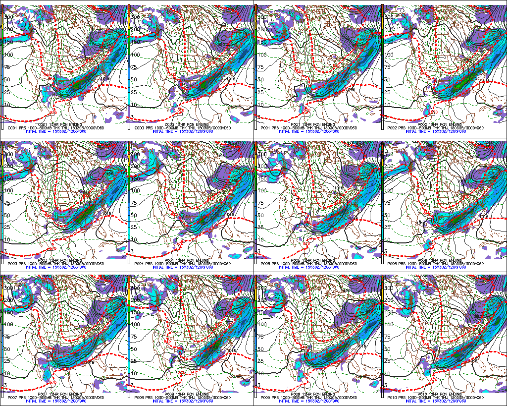
Note the AO and NAO strongly positive through the next 10-15 days.  This is the time of the year when these teleconnections can impact our region’s weather in the most significant way.  Both of these are warm signals taken at face value.

3


4


Note the pattern flip to a “flat” ridge by Day 10, indicative of the milder times ahead.

1


However, by Day 15 we notice the Alaskan ridge redeveloping.  This is NOT a signal for warm weather across our part of the region, as the steering currents would tap available cold air and direct it south into the Mid West and Ohio Valley.

1


So, what do we take from this?  We’re going to warm next week without question.  While the extent of the warming is up for debate, the overall milder times for a 5-7 period is a good call at this point.  On the flip side, we’re not ready to buy into the idea that spring is here for good just yet.  The building Alaskan ridge by the end of Week 2 would imply a cold close to March, and potentially continuing into early April.

Another item to keep a close eye on the upcoming 4-6 weeks?  Those NAO and AO signals.  Should they remain predominately positive this time of year then it’ll be exceptionally challenging to get any sort of cold pattern to lock in for more than a day or two.

Permanent link to this article: https://indywx.com/warm-up-coming/

Watching For Afternoon Snow…

Screen Shot 2015-03-04 at 7.56.01 AMLight Snow Moves In This Afternoon…While heavy snow will remain to our south, we do forecast light snow to overspread portions of central Indiana later this afternoon into the evening hours. This won’t be a huge deal, but a dusting to 1″ of accumulation will be possible around the city, itself.  Heavier snow will fall downstate.  Heads up if you’re traveling south.

The bigger story will be a MUCH colder air mass that arrives tonight and sets up a frigid Thursday.  We’ll be on record watch Thursday to potentially set a new record cold max.  It’ll be close.  Cold air remains with us to wrap up the work week.

A weak weather system will scoot north of the area Saturday night into Sunday morning, but may be close enough to provide a quick rain or snow shower.

Early next week looks dry with a moderating trend.  We’re expecting a more pronounced warm up for the second half of next week…60s, anyone?!

Upcoming 7-Day Precipitation Forecast:

  • 7-Day Rainfall Forecast: 0.10″
  • 7-Day Snowfall Forecast: Dusting to 1″

Permanent link to this article: https://indywx.com/watching-for-afternoon-snow/

Icy Morning…

Screen Shot 2015-03-03 at 7.58.16 AMRough Travel Conditions This Morning…Freezing rain and freezing drizzle is making a mess of the morning commute.  Thankfully, eventually we’ll climb above freezing around, or just after, noon.  Before then, icy travel conditions can be expected.  Take it slow or postpone travel until the afternoon if possible.  By this afternoon, temperatures will climb above freezing and plain ole rain can be expected into tonight.  We don’t anticipate flooding issues locally as rain won’t be heavy enough and temperatures won’t be warm enough to result in significant melting.

Much colder air will blow into town late tonight and Wednesday morning and as a second area of low pressure tracks along the front, widespread accumulating snow is a good bet across the southern half of the state Wednesday afternoon into Thursday morning.  As of now, we still target areas along and south of I-70 most at risk for snow accumulation Wednesday afternoon.

A much drier, but cold, pattern will be with us to wrap up the work week, including more record cold a good bet.  Dry and slightly milder conditions are ahead over the weekend before a weak system may deliver a light snow or rain shower early next week.

Looking ahead, it appears as if we finally may deal with a much milder, spring-like pattern around mid March.  60s for highs anyone?!  That said, concerns remain that we reverse this and go colder than normal late March.

Upcoming 7-Day Precipitation Forecast:

  • 7-Day Snowfall Forecast: 1″ – 3″ (south)
  • 7-Day Rainfall Forecast: 0.50″

In case you missed it this morning, we posted an article on meteorological winter and you can find it by clicking here.

Permanent link to this article: https://indywx.com/icy-morning/

A Word On Meteoroligcal Winter

We wanted to take a moment and discuss the 2014-2015 meteorological winter.  Going into the winter, we knew this would be one of many challenges. The nearly ideal SST profile…

You must be logged in to view this content. Click Here to become a member of IndyWX.com for full access.  Already a member of IndyWx.com All-Access?  Log-in here.

Permanent link to this article: https://indywx.com/a-word-on-meteoroligcal-winter/

A Lot To Discuss…

Good evening, friends!  As promised, there’s a lot on the weather menu over the course of the upcoming several days.  Let’s get right into the details.

The National Weather Service has issued a Winter Weather Advisory from 3a-12p for all of the region to account for the sleet and freezing rain situation we’ll deal with late tonight into the first half of Tuesday.  We still expect significant travel issues and overall impacts to the Tuesday morning commute.

Forecast radar shows freezing rain spreading into the region between 3 and 4am.

1Light freezing rain and freezing drizzle will continue for the better part of the morning hours as temperatures likely won’t climb above freezing until early Tuesday afternoon, especially from Indianapolis and points northeast.

Forecast temperatures at 12p Tuesday.

hires_t2m_indy_24We still don’t anticipate many big time flooding concerns as a.) temperatures won’t warm all that much (we MAY reach 40 Tuesday evening, but that’s a big question mark) and b.) most of the heavy rain will remain south of central Indiana.

Here’s expected liquid-equivalent totals through Wednesday morning.

2The next concern is the threat of accumulating snow for central and southern portions of the state Wednesday afternoon through Thursday morning. Arctic high pressure will limit the northern extent of significant precipitation, but, as mentioned previously, energy rounding the base of the trough will ignite another wave of low pressure to move along the pressing arctic front.  As of now, we target areas along and south of the I-70 corridor most under the gun for a potentially impactful snow storm Wednesday afternoon into early Thursday morning.

3The individual GFS ensemble members have also been trending north and overall more excited about snow prospects, as well.

7The other item on the agenda is a shot of record cold in here for late week.  Sub-zero lows are a good bet by Friday morning.  Highs Thursday will push for a new record low maximum temperature.

4

Permanent link to this article: https://indywx.com/a-lot-to-discuss/