Category: Arctic Cold

Sunshine Returns; Coldest Air Of The Season Awaits…

Highlights:

  • Sunshine returns
  • Coldest air of the season blows into town
  • Wet and cold close to the weekend

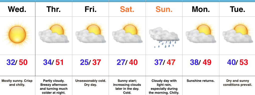
Coldest Air Of The Fall On Deck…High pressure is building in and will dominate our midweek weather, including sunshine and unseasonably cool temperatures.  We’ll add a gusty breeze into the mix Thursday afternoon as an early season arctic front approaches.  Once that front passes by Thursday night, a much colder air mass will plunge into the region.  If your travels take you north Friday, snowbelt regions can expect snow showers and embedded squalls as the early season arctic air helps ignite the lake effect machine.  Our first average high of 37° is on December 20th, so we’ll be running well ahead of schedule Friday.  Bundle up!

After a bright and sunny start Saturday, clouds will begin to increase during the afternoon and thicken up overnight as our next storm system approaches.  That storm system will deliver light rain Sunday.  Sunshine returns to kick off the new work week along with slightly below normal temperatures.

Upcoming 7-Day Precipitation Forecast:

  • Snowfall: 0.00″
  • Rainfall: 0.25″ – 0.50″

Permanent link to this article: https://indywx.com/sunshine-returns-coldest-air-of-the-season-awaits/

VIDEO: Coldest Air Of The Season Arrives To Close The Work Week…

You must be logged in to view this content. Click Here to become a member of IndyWX.com for full access.  Already a member of IndyWx.com All-Access?  Log-in here.

Permanent link to this article: https://indywx.com/video-coldest-air-of-the-season-arrives-to-close-the-work-week/

Unseasonably Chilly Pattern…

Highlights:

  • Sunshine works in today
  • Weak weather maker Tuesday
  • Chilly pattern turns downright cold to close the week

Have The Jackets And Coats Handy…After a rough Sunday filled with flooding and severe weather, we’re opening the work week on a much quieter, albeit much colder, note!  An overcast start to the day should gradually give way to increasing afternoon sunshine.  We’ve already experienced our high for the day (at midnight) and temperatures for most will remain in the 40s today, coupled with a brisk north breeze.

Our next weather maker will pass to our south Tuesday and this could spread a light shower as far north as central Indiana early Tuesday morning.  Better rain chances will remain across southern portions of the state, but even here rainfall amounts will remain light.

Dry, unseasonably chilly conditions will prevail for midweek before a stronger blast of chill pushes in to close the week.  This air mass will be of arctic origin and deliver the coldest temperatures so far this autumn.  A hard freeze is expected Friday and Saturday mornings.  Moisture will return over the weekend with light rain possible Saturday night into Sunday.

Upcoming 7-Day Precipitation Forecast:

  • Snowfall: 0.00″
  • Rainfall: 0.10″ – 0.30″

Permanent link to this article: https://indywx.com/unseasonably-chilly-pattern/

VIDEO: Severe Weather Sunday; Wintry Push In The Week Ahead…

You must be logged in to view this content. Click Here to become a member of IndyWX.com for full access.  Already a member of IndyWx.com All-Access?  Log-in here.

Permanent link to this article: https://indywx.com/video-severe-weather-sunday-wintry-push-in-the-week-ahead/

Turning Warmer, But Unsettled…

Highlights:

  • Another cold morning
  • Turning unsettled
  • Warmer heading into early next week

Warmer, But Rain Chances Return…Before we enjoy the warmer temperatures to close the week, we have one more very cold morning to go through.  Many central Indiana neighborhoods are once again starting the day in the mid to upper 20s.  Though we’ll add more clouds to our Thursday forecast (compared to all of that Wednesday sunshine), it won’t prevent temperatures from moderating close to seasonal levels later this afternoon.

Though we’ll mention a quick passing shower chance Friday, most of the day should be dry and the bigger story will actually be temperatures that approach 70° by the afternoon with periods of sunshine.  Sounds like a recipe for getting out of the office early and finding a local patio, huh?!

Unfortunately, shower chances will be on the uptick this weekend and while it won’t rain the entire time, really any time of the weekend is fair game for the potential of a shower or perhaps a thunderstorm.  As of now, best shower coverage should be Sunday.

Shower and thunderstorms chances continue early next week (Monday afternoon through Tuesday morning) before drier air and slightly cooler temperatures return the middle of next week.

Upcoming 7-Day Precipitation Forecast:

  • Snowfall: 0.00″
  • Rainfall: 1.00″ – 1.50″

Permanent link to this article: https://indywx.com/turning-warmer-but-unsettled/