Category: 7-Day Outlook
 Highlights:
- Scattered Showers And Storms
- Turning Much Cooler
- Unsettled Early Next Week
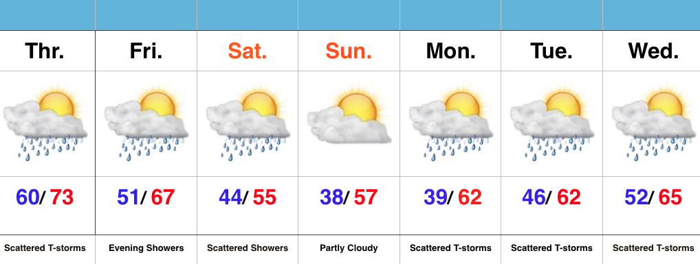
Have The Jackets Ready…The first of two cold fronts will sweep through the state this evening and help spark scattered strong to severe thunderstorms this afternoon and evening across mostly the eastern half of the state. A secondary cold front will move through here Friday evening with showers Friday night into early Saturday. It’s this second front that packs the much cooler air. Jackets will be required this weekend, and scattered light showers will remain in our forecast Saturday.
As we push into the new work week, things appear to be rather unsettled (what’s new)? An area of low pressure will push towards the region Tuesday into Wednesday and will increase rain and embedded storm chances. It won’t rain the entire time, but we’ll want the rain gear handy.
Permanent link to this article: https://indywx.com/scattered-strong-storms-this-afternoon-for-some/
 Highlights:
- Warm and humid mid week
- Turning much cooler for the weekend
- Unsettled times remain
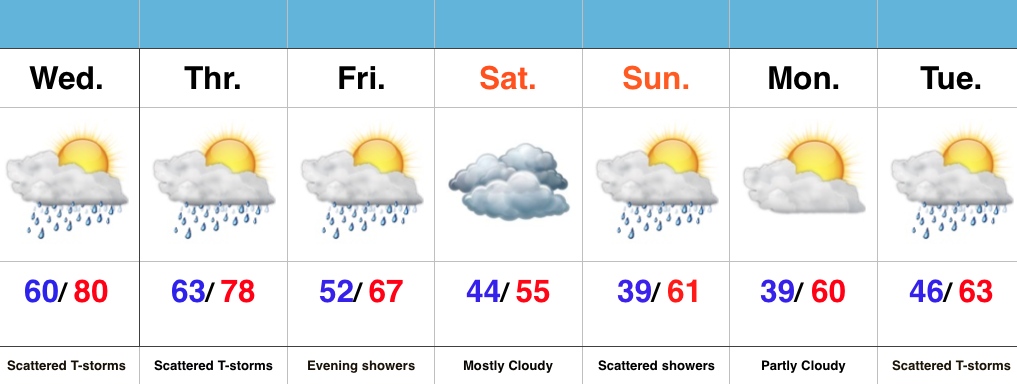
Jackets Required This Weekend…Wednesday’s coverage of showers and thunderstorms will likely be less than today, but will still require a mention of “scattered” coverage in our forecast. Some locally heavy downpours are possible, but like today, heavy rain totals won’t be uniform. Better coverage of showers and thunderstorms will move in early Thursday in association with a cold front. Once that cold front passes, expect a northwest wind shift and a much cooler feel of things to wrap up the work week and head into the weekend.
A weak disturbance will provide showers late Friday into the early morning hours Saturday, but this won’t amount to significant rain totals.
Cool times remain into early and middle parts of next week, with our next chance of significant rain slated for Tuesday.
Permanent link to this article: https://indywx.com/turning-much-cooler-to-close-the-week/
 Highlights:
- Scattered showers and storms continue
- Big cool blast looms
- Renewed wet stretch next week?
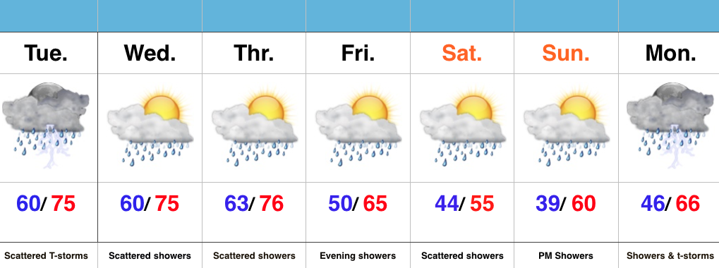
Active Times…It’s not so much the amount of rain that we’re seeing, but the overall duration of the gloomy, wet times. A stalled frontal boundary will remain draped over central parts of the state over the next 72 hours and this will help create periods of showers and thunderstorms through mid week. Localized heavy rain is possible, but the heavy rain totals certainly won’t fall in a “uniform” fashion. Tuesday afternoon and evening appears to still offer up a strong to severe thunderstorm chance.
Eventually a cold front will sweep the state Thursday and help usher in a much cooler air mass to wrap up the work week. An upper level disturbance will follow and provide a period of showers and light rain Friday evening. A spotty shower may continue Saturday with the much cooler air, but more widespread rains look to build in Sunday into Monday. There remains a great deal of disagreement on the forecast late in the weekend into early next week, so stay tuned as we fine tune things in the days ahead.
It’s a busy pattern, indeed, friends…
Permanent link to this article: https://indywx.com/busy-pattern-cool-blast-late-week/
An unsettled week ahead will feature periods of more widespread rain and stronger storms at times between now and Wednesday. We’re focused on Tuesday for the potential of strong to…
You must be logged in to view this content. Click Here to become a member of IndyWX.com for full access. Already a member of IndyWx.com All-Access? Log-in here.
Permanent link to this article: https://indywx.com/monday-morning-video-update-strong-storms-tuesday-much-colder-end-to-the-week/
 Highlights:
- Cool Mother’s Day
- Periods Of Rain And Storms
- Another Cool Blast Looms
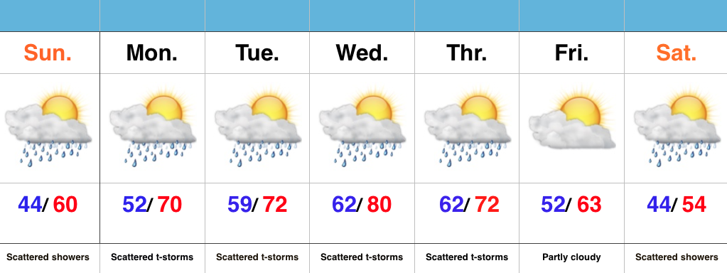
Have The Rain Gear Handy; Don’t Put Away Those Coats…A “wavy” frontal boundary will remain in our general vicinity over the next few days and be responsible for offering up periods of showers and eventually thunderstorms (as warmer, more humid air surges in Monday). It’s a “rinse and repeat” pattern this week as daily shower and thunderstorm chances continue. Models are in agreement on rain amounts of 1.5″-2″ between now and Thursday night, with locally higher amounts.
Eventually, a cold front will sweep through the state Thursday evening and set up a MUCH cooler than normal weekend. Instability-driven showers are possible Saturday, but the big story will be the unseasonably chilly air over the weekend into early next week.
Permanent link to this article: https://indywx.com/unsettled-week-another-cool-blast-looms/
