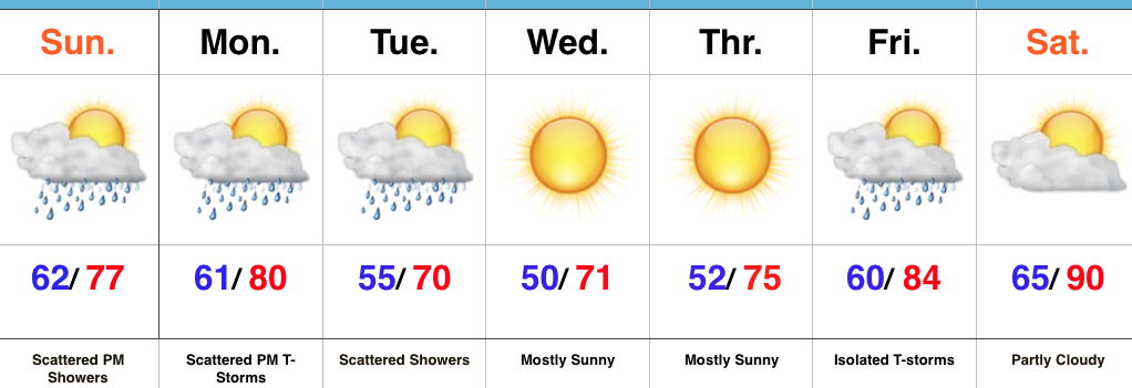
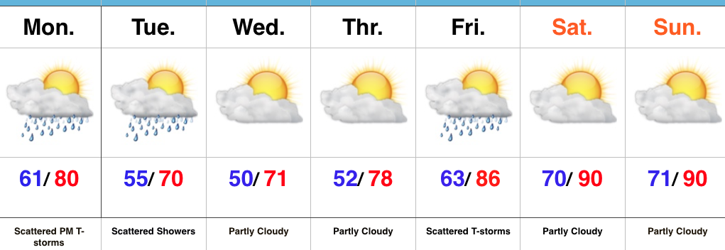
Turning Much Cooler…The sunny start to the work week will give way to scattered thunderstorms this afternoon and evening as a boundary slips through the region. While widespread severe weather isn’t expected, don’t be surprised if a couple storms require warnings later today.
A much cooler air mass will press into central IN tonight and set up a refreshing feel through the middle portions of the work week. We’ll take lows around 50 and highs around 70 any day of the week this time of year!
As we progress into the weekend, the hottest air of the season so far will build in. We expect lower 90s for highs and this hot surge could initially be accompanied by thunderstorms Friday. It’ll be quite oppressive as dew points zoom to around 70.
Scattered PM shower/ storm threat through early week
Cool, sunny mid week
Heat cranks next weekend
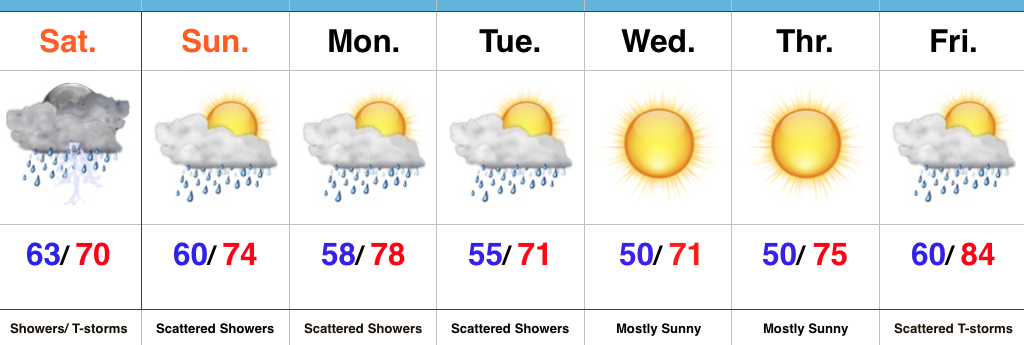
Turning Cooler By Midweek…After a significant rain event (on average 0.75″-1.4″ fell across central IN) Saturday, we’re starting our Sunday morning off with partly-mostly cloudy skies. A much less humid brand of air will build in today, but we can’t completely shake the rain chances. A scattered afternoon shower is possible.
Reinforcing cooler air will move in Monday and the associated boundary will likely do a better job kicking off scattered shower and thunderstorm activity as it moves through the region.
We’ll turn much cooler and refreshing for mid week, along with lots of sunshine and dry conditions. As you’d imagine, the refreshing air doesn’t last long this time of year and a SW flow will help temperatures and moisture levels surge to close the work week. The hottest air of the year so far is slated for next weekend.
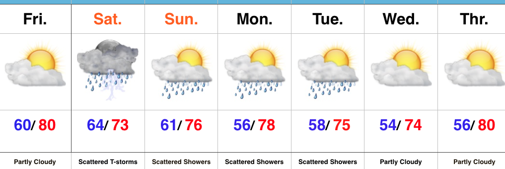
TGIF…The best weather day of the week has saved itself for Friday. Find a way to get outside and enjoy it! After a delay in the arrival of drier air, we’ll (finally) tap into lower dew points tonight into the day Friday, but it’ll be short-lived. Increasingly moist air will return as early as overnight Friday into Saturday. Drizzle and showers could accompany a warm front lifting north through the region during the wee morning hours Saturday. Additionally, thunderstorms are possible Saturday afternoon and evening as an upper trough surges southeast into the Ohio Valley.
The region will remain in a cooler, northwest flow pattern into early next week. With plenty of upper level energy around, showers are possible (scattered in nature) during the afternoon hours into Tuesday. Drier air will allow for partly cloudy skies to return to the forecast by mid week.
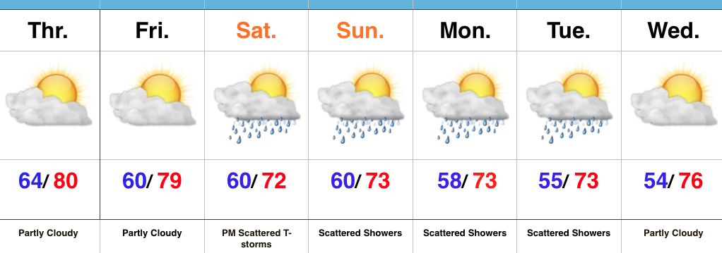
Turning Cooler Over The Weekend…A cold front tapped into available moisture and resulted in locally heavy rain Wednesday afternoon and evening. In some spots, as much as 2″ of rain fell in a very short period of time. We’ll begin to dry things out to wrap up the work week, along with partly cloudy and less humid conditions.
An upper trough will dig into the Ohio Valley Saturday and could help spark strong to potentially severe thunderstorms for portions of the region Saturday afternoon and evening. We’ll keep a close eye on things over the next day or two.
We’ll turn significantly cooler over the weekend into early next week. With plenty of upper level energy around the region, we’ll have to mention the chance of a scattered shower into early next week. Dry conditions return by the middle of next week.

 Highlights: