Category: 7-Day Outlook
 Highlights:
- Beautiful Saturday
- Storms return Sunday
- Much cooler next week
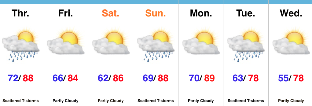
Couldn’t Ask For Better Weather…After a week filled with multiple days of rain and storms, we’re rewarded with simply phenomenal weather today! Dry conditions and mostly sunny skies will combine with lower humidity and highs in the mid/ upper 80s to create a great day to be outdoors.
Humidity will return Sunday and a frontal boundary will press in during the afternoon. Storm chances will be on the rise and a strong to severe storm can’t be ruled out. While storm coverage won’t be as widespread as this past week, we’ll keep an eye on the radar tomorrow evening.
The big story next week is the MUCH cooler air mass that will blow into town. A shower will accompany the unseasonably cool air Tuesday before we return to mostly dry conditions for the middle of the week.
Upcoming 7-Day Precipitation Forecast:
- Snowfall: 0.00″
- Rainfall: 0.25″-0.75″
Permanent link to this article: https://indywx.com/fantastic-saturday/
 Highlights:
- Stormy times later today, especially south
- Drier air mass works in
- Storms return Sunday
- Cooler to close the month
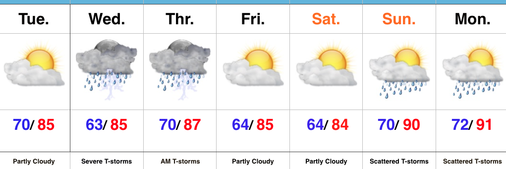
The Clean Up Begins…It was an active (and long) night across central IN as storms rumbled through. Thankfully, the clean up will take place with dry conditions today for most of us. For our southern viewers, we expect more widespread thunderstorms to fire during the afternoon and evening hours as a frontal boundary drops south. We think most of central IN is dry today.
A drier, more refreshing air mass will filter into the region to close the week and head into the weekend. Sunshine will prevail.
Warmth and humidity will be on the uptick for the second half of the weekend and storms will be associated with the moisture return. Saturday is definitely the pick of the weekend!
Cooler times loom to wrap up the month…
Upcoming 7-Day Precipitation Forecast:
- Snowfall: 0.00″
- Rainfall: 0.50″-1.00″
Permanent link to this article: https://indywx.com/drier-air-works-in-later-this-evening-eyeing-a-cool-close-to-the-month/
 Highlights:
- Needed quiet time today
- Stormy mid week; high-impact severe event possible
- Drier to close the week
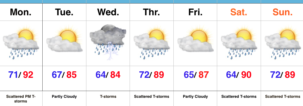
All Eyes On Wednesday…Today is an easy one. Drier air will move into central parts of the state as we progress into the afternoon and evening hours, and we’ll also enjoy lots of sunshine. It’ll feel fantastic out come evening!
All eyes will remain locked in on Wednesday as we monitor the prospects of potentially two rounds of thunderstorms. Timing and track will have to be fine tuned, but we think the day offers up the possibility of morning thunderstorms, followed by a second round of storms during the afternoon and evening hours. All modes of severe weather are in play, locally, Wednesday- particularly damaging wind. Additionally, localized flash flooding will be likely where storms train. It’ll be an important day to have a means to get the latest watches and warnings. It wouldn’t be a bad idea to review your severe weather safety plan with your family at some point today.
After morning storms Thursday we should dry things out during the second half of the day and on into the first half of the weekend. Storm chances return Sunday-Monday.
Upcoming 7-Day Precipitation Forecast:
- Snowfall: 0.00″
- Rainfall: 1.5″-2.5″ (locally heavier totals)
Permanent link to this article: https://indywx.com/needed-breather-today-before-wednesday-severe/
 Highlights:
- Front arrives late Monday
- Strong storms; heavy rain threat Wednesday
- Unsettled pattern
Busy Week Ahead…The overall pattern features the mean ridge position across the Four Corners region and sets up an active NW flow for our part of the country. It’s a pattern we need to get used to as it’ll remain intact to close the month and open July. Challenges are present in regards to specifics with timing and track of thunderstorm complexes we’ll deal with this week, particularly Wednesday.
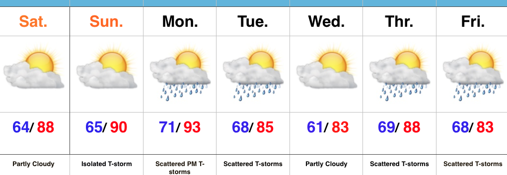
In the shorter term, a frontal boundary will slip into central IN Monday night and a broken band of thunderstorms will accompany it. A few storms could reach strong to severe levels Monday evening.
Attention will then shift to Wednesday. Ingredients are coming together to present both a severe component (damaging wind the biggest threat) and localized flash flood threat. We’ll update our latest thinking Monday morning.
As we progress into late week, additional shower and thunderstorm complexes are possible, but we stress timing issues abound. It’ll be a warm and humid end to the week.
Upcoming 7-Day Precipitation Forecast:
- Snowfall: 0.00″
- Rainfall: 1.50″-2.00″ (locally heavier totals)
Permanent link to this article: https://indywx.com/stormy-at-times/
 Highlights:
- Mostly dry and hot weekend
- Humidity levels on the rise Sunday
- Storm chances return
Put On That Sunscreen…High pressure will supply a beautiful open to the weekend, including mostly sunny to partly cloudy skies, low humidity levels, and warm temperatures.
Our airflow will shift to the SW Sunday and help push a more humid air mass back into the state as the day progresses. An isolated thunderstorm could accompany the return of the humid air, but for now we’ll maintain a mostly dry forecast.
Better thunderstorm chances arrive Monday evening into Tuesday as a cold front pushes in from the north. A locally strong to severe storm is possible. As we move forward into the middle and latter parts of next week, models suggest a rather unsettled time of things.
Upcoming 7-Day Precipitation Forecast:
- Snowfall: 0.00″
- Rainfall: 1″-2″
Permanent link to this article: https://indywx.com/mostly-dry-weekend-before-storm-chances-return/
 Highlights:
