Category: 7-Day Outlook

Unseasonably Cool; Heavy Rains…

Screen Shot 2016-07-03 at 10.14.18 AMHighlights:

  • Heavy rain
  • Unseasonably cool
  • Turning warmer
  • Active, stormy time later in the week

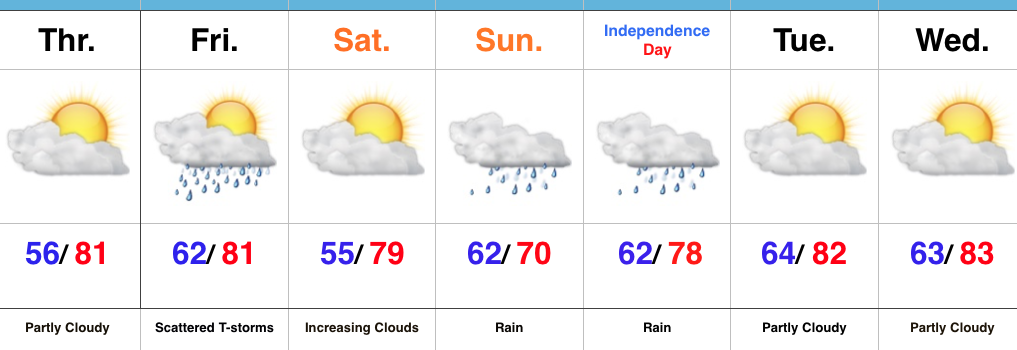
Jacket And Rain Gear Needed…The first of two rounds of widespread, soaking rains is pushing across central IN this morning.  Periods of moderate to heavy rains will develop later tonight as round two arrives on the scene.  Localized flooding is likely tonight and Monday morning.  The overall set-up is one that features a stationary front draped across the region with ripples of energy (low pressure) moving along the boundary.  In addition to the wet weather, this will also set up quite the temperature gradient across the state today.  Here across central IN, jackets will be needed all day with highs struggling to climb much out of the middle 60s.  Downstate, temperatures will zoom into the 80s with a severe component added into the mix tonight for southern IN (with the focus primarily being straight line winds).

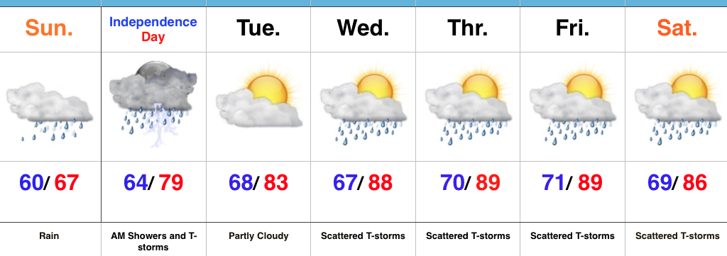
Showers and thunderstorms will continue Independence Day, but we’re still hopeful in thinking we begin to dry things out for the afternoon and evening.  That’s great news for the fireworks and festivities planned tomorrow evening.

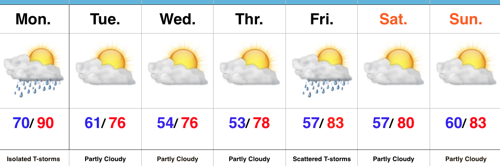
We begin to heat things back up and add storms into the mix for mid and late week as the region gets into an active NW flow regime.  The potential is there for a couple of rather noisy storm complexes later this week.  We’ll keep a close eye on things.

Upcoming 7-Day Precipitation Forecast:

  • Snowfall: 0.00″
  • Rainfall: 3.5″-4.5″ (locally heavier amounts)

Permanent link to this article: https://indywx.com/unseasonably-cool-heavy-rains/

Friday Morning Video Update: Pleasant Open To The Holiday Weekend Before Wet Times Build In…

You must be logged in to view this content. Click Here to become a member of IndyWX.com for full access.  Already a member of IndyWx.com All-Access?  Log-in here.

Permanent link to this article: https://indywx.com/friday-morning-video-update-pleasant-open-to-the-holiday-weekend-before-wet-times-build-in/

Enjoy The Dry Time While We Have It…

Screen Shot 2016-06-29 at 6.18.41 PMHighlights:

  • Pleasant air in the short-term
  • Storm chances Friday
  • Widespread soaker

Looking Increasingly Wet For The Holiday Weekend…High pressure will supply continued dry times Thursday, but clouds will increase during the evening and give way to scattered showers and embedded thunder Friday. This doesn’t look like a huge deal, but don’t be surprised by rain and/ or a clap of thunder to close the work week.  That said, there will be more dry time than wet Friday.

As we rumble into the long Independence Day weekend, confidence continues to increase for a widespread soaking rain to develop.  Thankfully, Saturday still looks mostly dry, but we think clouds will be on the increase late in the day, followed by rain overspreading the region from west to east as Sunday afternoon approaches.  Widespread rain should continue into Monday.  We still have questions on timing and precise placement of heaviest rains (2″+ totals), but it’s safe to say most, if not all, of the region can expect a long-duration rain event developing Sunday.  Stay tuned.  It’ll also be cool.  Areas where heaviest rains set up Sunday likely won’t climb out of the 60s.

Drier air will return late Monday into the middle of next week, but we caution that another wet weather maker appears to have eye on the region beginning next Thursday.

Upcoming 7-Day Precipitation Forecast:

  • Snowfall: 0.00″
  • Rainfall: 1.5″-2.5″

Permanent link to this article: https://indywx.com/enjoy-the-dry-time-while-we-have-it/

Monday Evening Video Update…

Cooler, more refreshing times are building in.  Temperatures come mid week will have you asking “Is this late June?!”

You must be logged in to view this content. Click Here to become a member of IndyWX.com for full access.  Already a member of IndyWx.com All-Access?  Log-in here.

Permanent link to this article: https://indywx.com/monday-evening-video-update-8/

Refreshing Feel On The Way…

Screen Shot 2016-06-27 at 8.35.11 AM

Highlights:

  • Isolated PM storm
  • Drier and much cooler air coming
  • Late week storm chance

Much Cooler Weather On Deck…A secondary cold front will slip through central IN this evening. While most of today will be rain-free, an isolated to widely scattered shower or storm can’t be ruled out as the front moves through later this evening.  Following the frontal passage, an unseasonably cool air mass will pour into the area and set up a very pleasant mid week stretch.  Hard to beat lower-middle 50s at night and 70s during the day in late June.

Our next chance of rain and storms will arrive Friday.  Early indications as of now suggest dry conditions and pleasant temperatures going into the long Independence Day weekend.

Upcoming 7-Day Precipitation Forecast:

  • Snowfall: 0.00″
  • Rainfall: 0.25″-0.50″

Permanent link to this article: https://indywx.com/refreshing-feel-on-the-way/