Snow Squalls Thursday Evening; Active Pattern…
 Highlights:
- Showers this evening
- Snow squalls develop Thursday evening
- Active weather pattern into next week
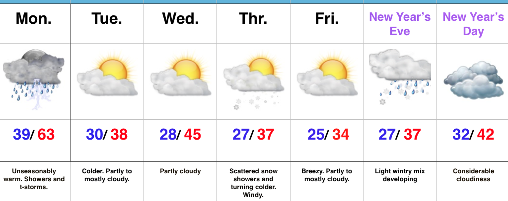
Early Sun Gives Way To Showers By Evening…A sunny, frosty start to the day will give way to an increasingly cloudy sky by afternoon and scattered showers by evening. Latest data suggests showers arrive into central Indiana by 6-7p. This won’t be a significant rain maker, but just enough to create damp conditions as we put a wrap on Wednesday.
A reinforcing push of cold air will blow through Thursday evening. With enough instability and upper air energy, scattered heavy snow squalls will become likely across the region by afternoon into the evening. This won’t be a “uniform” snow event, but some localized accumulation (thinking a coating to less than 1″ in spots), along with dramatic drops in visibility can be expected by evening as these scattered snow squalls increase in coverage. Additionally, winds will gust to 40 MPH and will aid in creating hazardous travel at times tomorrow PM. Scattered snow showers will continue into the day Friday.
Moving forward, we continue to eye the potential of a light wintry mix arriving on New Year’s Eve. As of now, this doesn’t appear to be a big deal, but we’ll monitor things as new data streams in. “Light” is the key word for now and temperatures look marginal, at best, for wintry issues.
As we rumble into next week, model consistency and overall agreement is rather non-existent. This leads to a lower than normal confidence on the important details in regards to the early week storm system (and looking forward, towards a second storm coming along just beyond the current forecast period). For now we’ll go with showers Monday afternoon paving way to more widespread rain Tuesday. As colder air rushes in Tuesday night, precipitation will change to snow along with a strengthening northwest wind and an increasingly bitter feel by the middle of next week.
Upcoming 7-Day Precipitation Forecast:
- Snowfall: 1″ – 2″
- Rainfall: 0.50″ – 1.00″