Category: 7-Day Outlook

Lots Of Dry Time This Weekend, But Scattered Storms Will Be Around…

Screen Shot 2015-05-09 at 10.38.36 AMHighlights:

  • More dry time than not this weekend
  • Strong storm potential Monday
  • Cooler and much drier air moves in Monday night

The region remains in a very warm and moist air mass this weekend and this could help promote a scattered shower or thunderstorm really at any point over the next couple of days.  That said, best concentration of rain and storms will come during the afternoon and evening hours.  All-in-all, the weekend will feature many more dry hours than not.  A final push of showers and thunderstorms will blow through Monday and some of these could reach strong to severe levels.  We’ll keep a close eye out.  A much cooler and drier air mass arrives Monday night and that will carry us through Thursday.
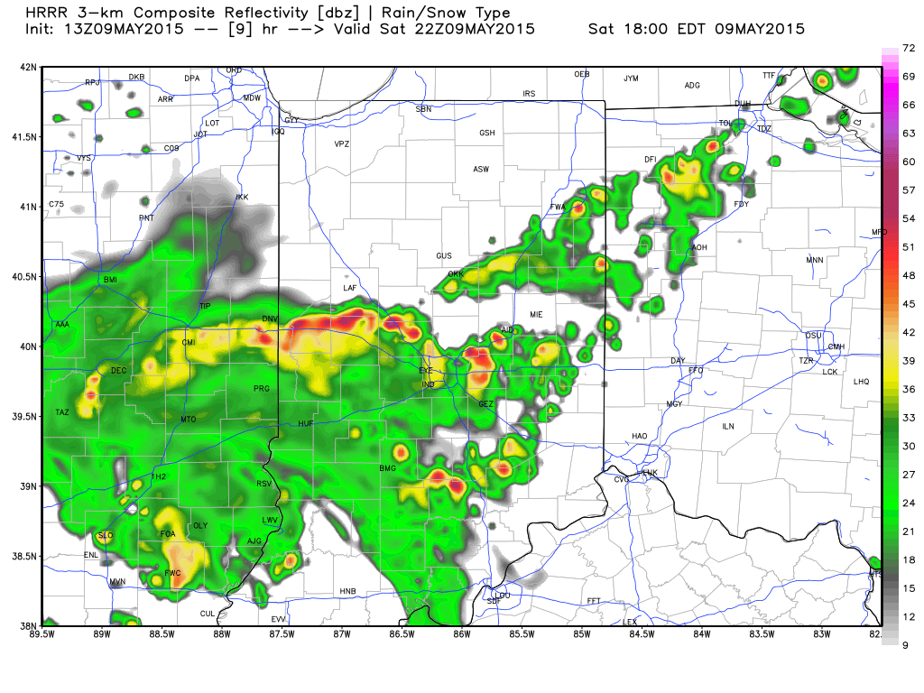
hrrr_ref_indy_10Most of today will be dry, but forecast radar (courtesy of Weatherbell.com) suggests showers and thunderstorms build into central IN this afternoon and evening.  Plan on taking rain gear with you if you have outdoor plans and have a means of getting inside should a storm be nearby.

day3otlk_0730The SPC has highlighted a large portion of the Ohio Valley for the threat of severe weather Monday.  Large hail and damaging winds appear to be of greatest concern at this time.  While this doesn’t look like a significant widespread severe weather outbreak for our immediate region, let’s remember it only takes one severe storm impacting a community to be significant in that particular neighborhood.

Permanent link to this article: https://indywx.com/2015/05/09/lots-of-dry-time-this-weekend-but-scattered-storms-will-be-around/

Summer-like Turns Much Cooler Next Week; Storms In Between…

Screen Shot 2015-05-06 at 10.29.34 PMHighlights:

  • Feeling like summer
  • Storm chances ramp up going into the weekend
  • Best chances of widespread rain arrives Monday
  • Much cooler next week

As we get set to put a wrap on another busy work week, near record warmth is the big weather story.  Those unseasonably warm conditions we’ve dealt with over the past few days will continue into the weekend, but we’ll also add rain and storm chances.  Coverage of thunderstorms will be categorized as “isolated” Friday, “scattered” Saturday and Sunday, and “widespread” Monday.  As moisture continues to surge into the region, locally heavy downpours can be expected, and a downright muggy feel.  A severe storm is certainly possible, but the more widespread severe outbreak will remain to our west across the central Plains region.  Much cooler air will pour into the region behind a Monday night frontal passage.

2As we type this (around 10p Wednesday evening), temperatures are still in the middle 70s and a whopping 15-20 degrees above average this hour across the area.

1Think it’s humid now?  Just wait until the weekend.  A strong southwest flow will pull moisture-rich air northward, courtesy of a Gulf of Mexico connection.  Dew points will approach 70 degrees across many southern and central IN communities and help fuel locally heavy rainfall with any storm that develops Friday night through Monday.

3A MUCH cooler air mass will filter into the region behind the cold frontal passage Monday night/ early Tuesday.  After a week of summer-like heat, upper 50s for highs will feel downright chilly.

Permanent link to this article: https://indywx.com/2015/05/06/summer-like-turns-much-cooler-next-week-storms-in-between/

Warm Temperatures & Increasing Humidity…

Screen Shot 2015-05-03 at 8.41.38 PMHighlights:

  • Widely scattered storms Monday
  • Very warm with increasing humidity this week
  • Weekend storms

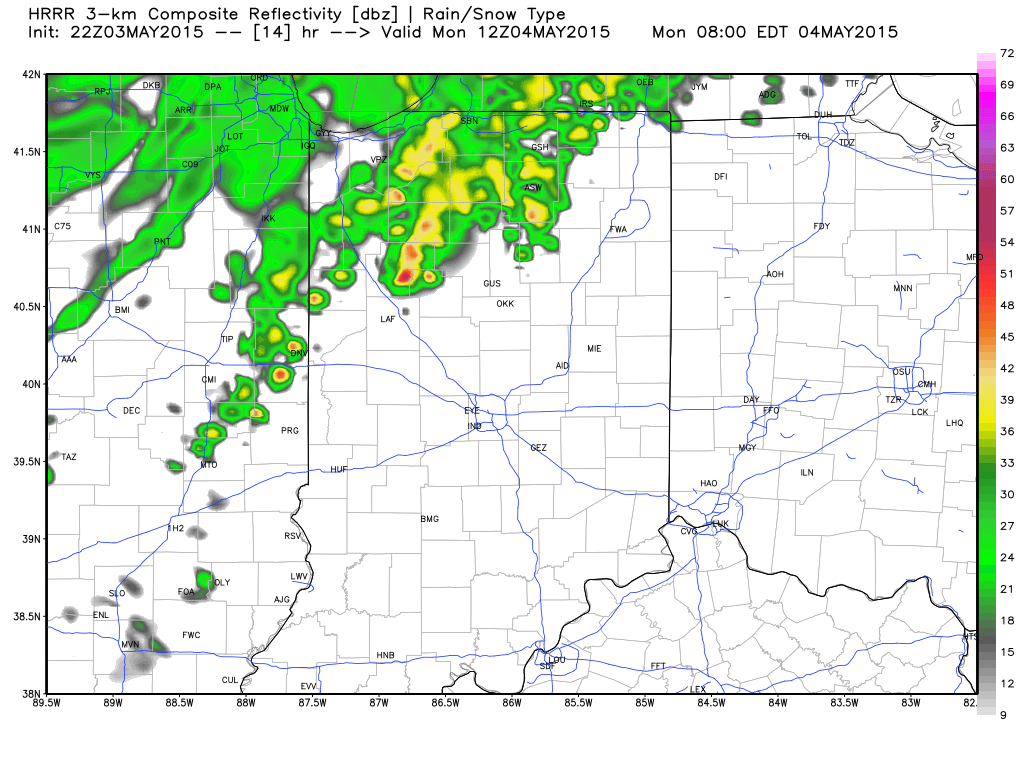
1Forecast radar (above), courtesy of Weatherbell.com, shows showers and thunderstorms pressing into the state early Monday morning.  This is all part of a frontal boundary that will slip into northern IN Monday before stalling through the mid week stretch.  Most widespread coverage of showers and storms will be confined to northern portions of the state, but we’ll also include a mention of widely scattered showers and thunderstorms for central IN Monday.  Traveling north this week?  Plan on better rain chances as compared to that we’ll see.

The majority of the upcoming work week will feature dry conditions and unseasonably warm temperatures.  A prolonged southerly and southwesterly air flow will provide an increasingly muggy feel to the air this week.

Better coverage of showers and thunderstorms will roll in over the weekend thanks to an approaching storm system.

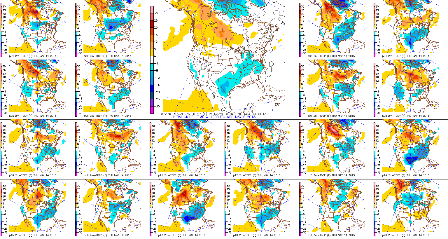
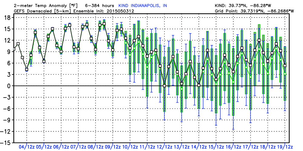
3The majority of our mid to long range forecast data suggests the warm pattern we’ve enjoyed to kick off May will continue deep into the month.  Ensemble guidance (above) shows a snap shot of temperature anomalies through the 19th of May.  As you can see, temperatures will be significantly above normal through the first ten days, or so, of the month.

Permanent link to this article: https://indywx.com/2015/05/03/warm-temperatures-increasing-humidity/

Cool And Showery Thursday; Full-Blown Spring Warmth Ahead!

Screen Shot 2015-04-29 at 10.22.29 PMHighlights:

  • Scattered showers; unseasonably cool today
  • Brighter; warmer days ahead
  • Questions next week in regards to rain/ storm potential

A vigorous upper level low will pivot through the Ohio Valley Thursday.  This will provide the threat of a shower really at any point through the day.  Unseasonably cool air and a gusty wind will also be in place.  This will be a brief set back from what, otherwise, is a full-blown burst into spring/ early summer type weather over the weekend into next week.

We’ll keep a very close eye on the placement of a ridge to our southeast early next week as this will mean the difference between a mostly dry and warmer pattern and one that could, potentially, be periodically stormy.  As things stand now, models are trending drier, with the so-called “ring of fire” pattern placed just north of central Indiana.  We’ll keep a close eye on things.

1Simulated radar (above) shows scattered showers dotting the region Thursday, thanks to a potent upper low moving through the Ohio Valley.  Unseasonably chilly air (forecast highs in the mid/ upper 50s shown below) and gusty winds will also accompany this system.  Rainfall amounts will be light for most and generally under one tenth of an inch.

2Our weather early next week will largely depend on the strength and placement of a ridge of high pressure centered over the southeast region.  Models today have trended drier for our immediate region and, as such, we’ll follow suit with our forecast above.  That said, we note models can struggle with the precise details of these patterns in the mid range and things could trend back towards the direction of stormier times.  Stay tuned.

3Regardless of storm chances next week, temperatures will be drastically warmer than what we’ve dealt with over the past couple weeks.  Ensembles (below) show the warmer than average pattern engulfing the region and a large portion of the Ohio Valley and Mid West.

4

Permanent link to this article: https://indywx.com/2015/04/29/cool-and-showery-thursday-full-blown-spring-warmth-ahead/

Thursday “Bump In The Road” En-route To A Warmer Regime…

Screen Shot 2015-04-28 at 9.50.15 PMHighlights:

  • Increasing late day clouds and Thursday showers
  • Warmer days going into the weekend and early next week
  • Stormy at times early next week

Wednesday will get off to a chilly start, but we’ll be several degrees warmer than recent mornings.  We should see enough sunshine to help boost temperatures into the lower to middle 60s before clouds increase and thicken by evening.  This is in association with an upper level low that will track over the region Thursday.  This UL will serve up scattered showers Thursday (0.10″ – 0.25″ rain potential in spots) and it’ll be another unseasonably cool day.

Brighter days are ahead as we progress into the weekend with increasing sunshine Friday and continuing Saturday.

Moisture will increase Sunday into Monday as our wind flow backs around to the southwest. This will pull increasing moisture into the Ohio Valley and we’ll watch for a couple of disturbances to kick off scattered showers and thunderstorms.  The big story next week will be a much warmer pattern.

1After a dry Wednesday, forecast radar (courtesy of Weatherbell.com) shows showers building into central IN Wednesday night and Thursday morning.  It won’t rain the entire day Thursday, but scattered showers will dot the landscape at times.  As mentioned above, rainfall totals will be light.  It’ll be a cool day (mid to upper 50s for highs as shown below) with showers, clouds, and a gusty north wind in play.

2Our air flow will back to the southwest and help transport a more humid brand of air into the region early next week.  This warmer, moist air mass will likely be accompanied by scattered showers and thunderstorms Sunday and Monday.

3

Permanent link to this article: https://indywx.com/2015/04/28/thursday-bump-in-the-road-en-route-to-a-warmer-regime/

Warmer Days Coming, But Cool Continues In The Short Term…

Screen Shot 2015-04-27 at 10.18.12 PMHighlights:

  • Cool weather continues through mid week
  • Upper low spawns shower chance Wednesday-Thursday
  • Dry, warmer close to the week
  • Much warmer and more humid early next week with storm chances

1After a cool open to the work week, the next couple of days will continue a similar theme.  We’ll enjoy more sunshine Tuesday when compared to Monday afternoon and temperatures should be a degree or two warmer.

Attention will shift to a potent upper level area of low pressure dropping across the region in the mid week time period.  This will do two things of note- provide reinforcing cool air and help create a scattered shower chance in the Wednesday-Thursday time period. (Scattered 0.10″ to 0.25″ rainfall amounts).

Weather conditions will begin to relax as we put a wrap on the work week.  Expect increasing sunshine and a much warmer pattern.

Warmth and humidity will continue to build early next week and help add fuel to storm potential.

2It’s a rather anomalous look to the 500mb (upper air pattern) charts for mid week, courtesy of Weatherbell.com.  A potent upper level low will dive southeast across the region and help spawn a shower chance, along with provide a much cooler feel of things Wednesday night into Thursday.  Surface low pressure will develop along the SE coast (in response to the UL energy diving southeast) that will provide a windy/ rainy end to the week across coastal regions down east.

3Warmer days are ahead, and more humid days, as well.  Our wind flow will back to the southwest late in the weekend and early next week.  Temperatures will respond, but so will humidity levels.  Throw in a little energy and you have the makings for stormy times to open up next week.

Permanent link to this article: https://indywx.com/2015/04/27/warmer-days-coming-but-cool-continues-in-the-short-term/

Wet Today; Much Better Sunday!

Screen Shot 2015-04-25 at 9.33.34 AMHighlights:

  • Wet, at times, today
  • Increasing Sunday sunshine
  • Small rain chance mid week
  • Warming trend late week

SAT_EUS_WVENH_ANIThis morning’s water vapor loop, courtesy of Weathertap.com, shows low pressure and the associated “big spin” over the mid section.  This will continue to slowly track east, southeast as we go through today and will provide the chance of showers and embedded thunderstorms at any point today into the evening hours.  Severe weather is possible across southern IN on south into KY and TN.  Heads up if your travels take you that direction today and have a way to get the latest weather information.  A much brighter Sunday is ahead and this will set the stage for a calmer week overall when compared to this past week.

hires_ref_indy_11Forecast radar, courtesy of Weatherbell.com, shows heavier and more widespread rains lifting into the region early this afternoon.  Today’s rainfall totals, however, don’t look as heavy as what was expected earlier this week.  Now we’re thinking most will fall in the 0.50″ range, with locally heavier totals under spots that see a thunderstorm.

Permanent link to this article: https://indywx.com/2015/04/25/wet-today-much-better-sunday/

Frosty Weather Turns Wet Saturday…

Screen Shot 2015-04-22 at 7.02.51 PMHighlights:

  • Frosty start Thursday and Friday for some
  • Wet, chilly, and raw Saturday
  • Brighter 2nd half of the weekend
  • Watching next week

4Tonight’s water vapor loop, courtesy of WeatherTap.com, is showing drier air making it’s way into our region.  This will set the stage for plentiful sunshine Thursday and Friday (well deserved, I might add :-)).  Winds will also begin to diminish this evening.  The combination of winds going calm and clearing skies will promote the chance of a frost and freeze across central IN tonight (and likely again tomorrow night) as reinforcing chilly air pours into the region.  Those with ag. interests be sure to take note.

Attention then turns to the weekend and we’ll label it as “half-n-half” for now.  A wet, chilly, and raw Saturday should give way to increasing sunshine Sunday.  Early to mid next week will provide a new set of challenges and we’re leaning towards the wetter solutions yet again.  Keep in mind the drier forecast model sets (GFS in particular) had to come around and play catch up to those leading the way Saturday (EC and GEM).  Expect changes and stay tuned.

1Forecast lows tonight, thanks to Weatherbell.com, are suggested to fall into the lower to middle 30s.  Should the wind go calm then expect a few readings around 30 degrees.  We’ll likely dip near these readings again Friday morning.

2After a dry close to the work week, moisture increases late Friday night into Saturday morning.  Expect a wet Saturday with early rainfall numbers projected in the 0.50″ to 1″ range.

5


3

Permanent link to this article: https://indywx.com/2015/04/22/frosty-weather-turns-wet-saturday/

Rain Early Wednesday Morning; Chilly Pattern Continues…

Screen Shot 2015-04-21 at 9.39.23 PMHighlights:

  • Unseasonably chilly air arrives behind a band of showers
  • Needed dry time Thursday-Friday, but frost potential looms
  • Wet, cold, and raw Saturday

It’s been a chilly and WINDY open to the week.  After a day of sunshine Tuesday, clouds thickened Tuesday evening and showers aren’t far behind.  We forecast a band of light to moderate rain to move north to south during the overnight period- particularly between 1a and 5a.  Unseasonably cool air will be the rule as we wrap up the work week and head into the weekend.  A new storm system looks to deliver widespread rain Saturday.  Factor in temperatures running well below average and you have the makings for a rather nasty Saturday (a far cry from last Saturday’s sunshine and 80 degree warmth).

1A band of showers will move through central IN Wednesday morning and will be followed by another push of unseasonably cool air.  Forecast radar shown above, courtesy of Weatherbell.com, shows overnight rain moving through the region.  Between one tenth and one quarter inch is a good bet.

3High resolution forecast models suggest many dip to around freezing Thursday and Friday morning.  Those with ag. interests, take note.

2Wet weather returns Saturday.  The European and Canadian forecast models led the way with this system and now the GFS (shown above) is playing catch up towards a cold and wet Saturday.

Permanent link to this article: https://indywx.com/2015/04/21/rain-early-wednesday-morning-chilly-pattern-continues/

Heading In The Wrong Direction…

Screen Shot 2015-04-20 at 3.32.01 PMHighlights:

  • Prolonged unseasonably cool weather
  • Band of showers late Tuesday night/ early Wednesday
  • Frost potential late week
  • Watching a storm system Friday night/ Saturday

SAT_ERG2_VIS_ANISurface low pressure is wrapping up over the Great Lakes region this afternoon with a much cooler air mass flowing into IN.  Though the steady widespread rains have ended, we will maintain a mention of spotty showers into the evening before diminishing.  It’s a gusty day and that will continue.  Most of Tuesday will be rain-free and cool, but a reinforcing push of chilly air will blow into the region late tomorrow night and Wednesday morning, and this will likely be accompanied by a band of showers.  Unseasonably cool air will be the rule through the forecast period.  The next potential “trouble maker” on the radar will take aim on the region late Friday into Saturday.  Forecast models don’t agree on the northward extent of the steady rains, but based off experience and the time of the year we’ll lean towards the solutions favoring a more northerly track.  Stay tuned.

1Forecast radar shown above, courtesy of Weatherbell.com, highlights Tuesday night/ early Wednesday for the threat of a band of showers in advance of a reinforcing push of cool air.

2The next item on the agenda features the potential of wet, chilly, and just downright raw times closing the week and heading into the weekend.  The Canadian model, shown above, is one of a couple models with a more northward flavor of rain Friday night into Saturday.

3Chilly times are the rule for the foreseeable future, friends.  After a warm April (to date), a combination of the GFS and European computer guidance suggests highs are below 60 for the upcoming 10 days.

Permanent link to this article: https://indywx.com/2015/04/20/heading-the-wrong-direction/

IndyWx.com