Bumpy Start To The Work Week…
 Highlights:
- Stormy open to the work week
- Colder midweek
- Storms return this weekend
Couple Rounds Of Storms Possible Today…Radar this morning is showing widespread showers and thunderstorms sinking south out of northern Indiana. Expect to get wet in, and around, the city as the rush hour gets into full swing. We’ll monitor this evening for the potential of another round of thunderstorms that’ll, once again, originate across northern IN before tracking southeast. We don’t anticipate widespread severe weather with these rounds of storms, but small hail is certainly possible in some of the storms.
Tuesday will be an overall quieter day, but a cold front will pass with a shower chance Tuesday evening. We’ll then note a northerly wind shift and a much colder air mass Tuesday night through Thursday morning. Highs Wednesday will run 10°-15º below average. If you’re not a fan of the cold, no need to fret as a warmer southerly flow will develop Thursday afternoon and put us in position to return to seasonable levels for highs Thursday after the chilly start. We’ll then run much warmer than average this weekend, but it comes with a wet and stormy trade off. Periods of heavy rain are possible Saturday into Sunday.
Upcoming 7-Day Precipitation Forecast:
- Snowfall: 0.00″
- Rainfall: 1.25″ – 1.75″
 Highlights:
 Highlights:
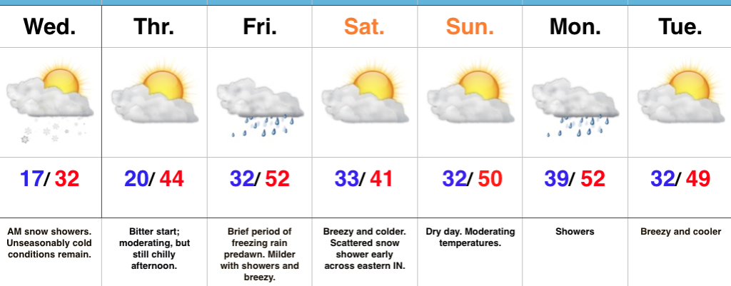 Highlights:
 Highlights: