Tracking A Couple Of Cold Fronts This Week…

Highlights:

  • Calm open to the work week
  • Two cold fronts impact the region
  • Much colder air blows in this weekend

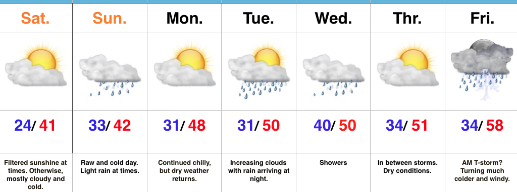
Calm Open; Busy Close…The work week will open with weak high pressure in control of our weather.  This will result in sunshine returning along with unseasonably chilly conditions (average highs are in the mid 50s this time of year).

The first of two cold fronts will push through the state Wednesday.  Clouds will increase Tuesday evening and showers will blow into town Wednesday morning.  Breezy and chilly conditions will go along with the damp weather.

A second (stronger) cold front will impact the area to close the work week.  Strengthening low pressure will move through the Great Lakes Friday evening and help pull a briefly warmer air mass into the state.  Showers and thunderstorms will be widespread ahead of the approaching cold front and a few of these could be strong to severe.  We’ll keep a close eye on things over the next couple of days and update accordingly.  Strong and gusty southwesterly winds will reach 40 MPH+ before shifting around to the northwest once the trailing cold front sweeps through the region.  This will drive a sharply colder air mass southeast and the potential is there for lingering moisture to end as a touch of wet snow late Friday night.  The weekend will feature dry, windy, and unseasonably cold conditions.

Upcoming 7-Day Precipitation Forecast:

  • Snowfall:  Trace
  • Rainfall: 1.00″ – 1.50″

Unseasonably Cold; Weekend Ends Messy…

Highlights:

  • Filtered sunshine today
  • Raw and messy Sunday
  • Fast-moving weather pattern next week

Bundle Up…Wake up temperatures are more like we’d expect in late December as opposed to early November, including lower to middle 20s across central Indiana.  Filtered sunshine will eventually give way to a thickening cloud deck late.  Those clouds will be a harbinger of things to come as moisture overspreads the region Sunday morning.  Look for a cold, raw close to the weekend with periods of light rain (sleet may mix in with the rain during the onset early Sunday, but this won’t be a big deal).

We’ll open up the work week with dry and chilly conditions before a couple of fast-moving systems impact our mid and late week weather.  Clouds will increase Tuesday and showers will arrive at night, continuing into Wednesday.  Our next (stronger) storm will arrive to wrap up the work week.  A southwesterly air flow will inject briefly milder air Friday morning and may be sufficient enough to create a couple of thunderstorms.  We’ll then transition to a much colder, windy regime to wrap up Friday with falling temperatures.

Upcoming 7-Day Precipitation Forecast:

  • Snowfall: 0.00″
  • Rainfall: 1.00″ – 1.50″

Sunshine Returns; Coldest Air Of The Season Awaits…

Highlights:

  • Sunshine returns
  • Coldest air of the season blows into town
  • Wet and cold close to the weekend

Coldest Air Of The Fall On Deck…High pressure is building in and will dominate our midweek weather, including sunshine and unseasonably cool temperatures.  We’ll add a gusty breeze into the mix Thursday afternoon as an early season arctic front approaches.  Once that front passes by Thursday night, a much colder air mass will plunge into the region.  If your travels take you north Friday, snowbelt regions can expect snow showers and embedded squalls as the early season arctic air helps ignite the lake effect machine.  Our first average high of 37° is on December 20th, so we’ll be running well ahead of schedule Friday.  Bundle up!

After a bright and sunny start Saturday, clouds will begin to increase during the afternoon and thicken up overnight as our next storm system approaches.  That storm system will deliver light rain Sunday.  Sunshine returns to kick off the new work week along with slightly below normal temperatures.

Upcoming 7-Day Precipitation Forecast:

  • Snowfall: 0.00″
  • Rainfall: 0.25″ – 0.50″

Severe Weather Sunday; Much Colder Next Week…

Highlights:

  • Clouds more bark than bite today
  • Stormy setup Sunday
  • Trending colder next week

All Eyes On Sunday…The cold front that passed through the region Thursday night and setup the gorgeous close to the work week is lifting back north this morning as a warm front.  This will result in overcast conditions today, areas of sprinkles or drizzle later in the day, and rising nighttime temperatures.  Scattered thunderstorms will develop across central Indiana late tonight with a warmer and increasingly moist environment.

Sunday will certainly be a day to remain weather-aware.  The overall setup hasn’t changed from what was discussed yesterday with a warm and moist southwesterly air flow in place ahead of an approaching cold front and associated area of low pressure.  Additional ingredients in play suggest we need to monitor the threat of large hail, damaging straight line winds, and potentially tornadoes.  Individual storms (potential super cells) are expected to fire across central and northern portions of the state Sunday afternoon into early evening.  These will be capable of quickly pulsing to severe levels and include potential of large hail, as well as tornadoes (particularly in the vicinity of the warm front which is expected to be draped across north-central parts of the state).  Individual cells are anticipated to “morph” into a squall line Sunday evening, including potential of a quick spin-up tornado, as well as damaging straight line winds.  With a moisture-rich air mass in place (precipitable water values are expected to approach 2″ Sunday evening), locally heavy rainfall is also expected.

All of our “excitement” will come to an end overnight Sunday and we’ll trend much colder (and calmer) during the new work week ahead.  Our next storm system will pass by to our south Tuesday, but may be close enough to spark a light shower across central portions of the state.  Drier and colder conditions build in later in the week.

Upcoming 7-Day Precipitation Forecast:

  • Snowfall: 0.00″
  • Rainfall: 1.50″ – 2.50″