Wintry Forecast; New “Plowable” Snow Event Arrives Monday…
 Highlights:
- Sleet changes to snow
- New snow and wind maker Monday
- Bitter air returns
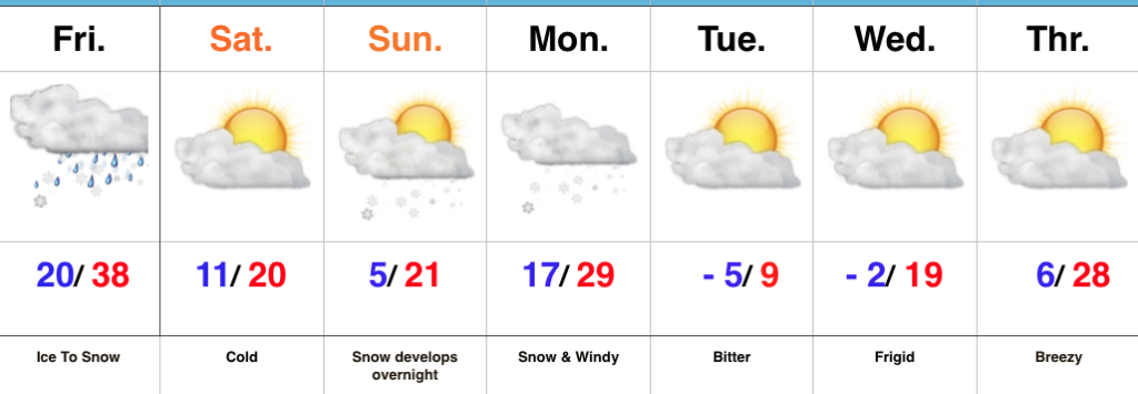
Double Shot Of Impactful Winter Weather…A mixture of sleet and freezing rain will begin to transition to snow from west to east as we progress through the late morning into the early afternoon. We don’t have any significant changes to our snowfall forecast (remember this doesn’t include the freezing rain and sleet accumulations that have led to travel issues this morning already). Embedded snow bands will likely result in enhanced snowfall rates into the early afternoon across central Indiana.
 Precipitation will end for all except southeastern portions of the state by mid-to-late afternoon and then we’re left with the “clean up” from round one. Saturday and most of Sunday will feature dry and very cold conditions.
Our attention this weekend will then shift to a potent clipper system that has eyes on central Indiana late Sunday night into Monday. Snow will overspread the region during this timeframe and given the nature of this event, heavier, more intense snow bursts are also expected to accompany the fresh arctic air that will drill in here Monday evening. This will be an impactful event not only from the new falling snow, but from problems that wind and drifting will bring, along with a new batch of sub-zero temperatures. Our snowfall forecast Monday hasn’t changed since yesterday, including widespread additional amounts of 2″ to 4″.
 Dry, but bitterly cold conditions return for the mid and late week stretch.
Upcoming 7-Day Precipitation Forecast:
- Snowfall: 3″ to 6″
- Rainfall: 0.00″
*Please note the 7-day precipitation forecast outlined above is for Indianapolis proper.
 Highlights:
 Dry conditions will return Saturday along with a much colder feel. Quiet times won’t last long as another snow system will quickly begin to impact the state Sunday evening into Monday. Widespread steady snow is expected to develop and will actually be a more uniform, bigger, event for most of the viewing area. We’ll add in wind and arctic air which will lead to blowing and drifting issues as the day progresses Monday into Tuesday. Here’s our first call for additional snow amounts Sunday evening-Monday.
 The forecast period will wrap up dry and bitterly cold. With a fresh snowpack down, it’s safe to say we’ll add at least another night to the sub-zero “club!”
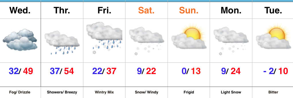 Highlights:
 Highlights:
 Highlights: