Category: 7-Day Outlook
|
Wed.
|
Thr.
|
Fri.
|
Sat.
|
Sun.
|
Mon.
|
Tue.
|
|

|

|

|

|

|

|

|
|
67/ 81
|
64/ 80
|
56/ 80
|
57/ 81
|
59/ 83
|
68/ 84
|
70/ 84
|
|
Light
|
Light
|
– – –
|
– – –
|
– – –
|
Light
|
Light
|
The summer mugginess continues today and into Thursday, and with a frontal boundary sinking south this afternoon this will combine with the humidity to create localized heavy down pours with any thunderstorm that gets going. We think coverage of showers and thunderstorms will be most numerous today over central Indiana. A very warm and humid air mass will remain intact through Thursday, but we still forecast a nice push of much drier air in here for the weekend. Northeast winds will allow very pleasant humidity levels to back in here for the Friday-Sunday time period. Hoosiers continue to luck out with the timing as the weekend looks beautiful followed by resurgent warmth and humidity (and associated shower and thunderstorm chances) as early as Monday. Some of the most humid air of the season will blow into town early next week and potentially help fuel more locally heavy downpours.
In case you missed it:
“Another Nice Weekend In The Middle Of An Unsettled Pattern…”
Permanent link to this article: https://indywx.com/locally-heavy-rain-producing-storms-this-afternoon/
-
Filed under 7-Day Outlook, Canadian Model, Forecast, Forecast Discussion, Forecast Models, GFS, Heavy Rain, Long Range Discussion, Rain, Summer, T-storms, Unseasonably Warm, Weather Rambles, Weather Videos
-
May 27, 2014
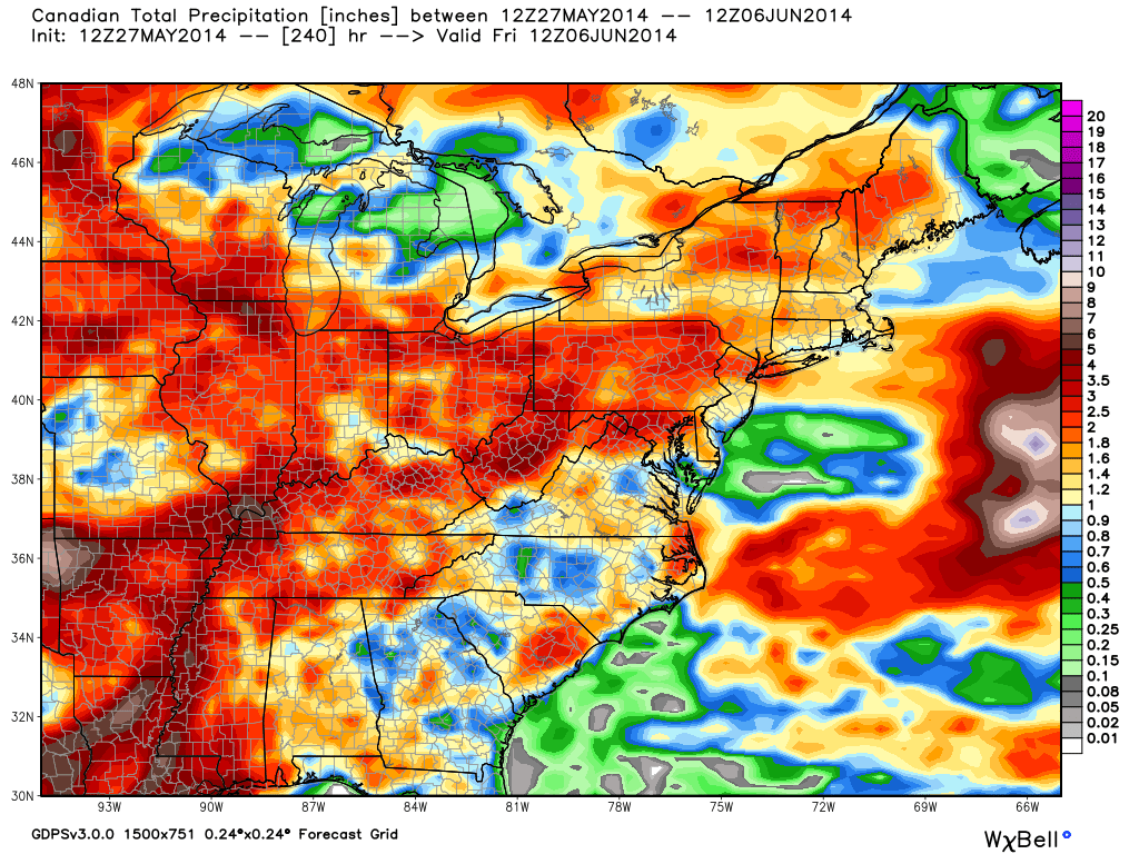
The upcoming 7-10 days looks unsettled overall and quite wet. That said, we’re set to enjoy another beautiful weekend with a refreshing northeast breeze in play. We discuss this and look deeper into the month of June in this evening’s video update below!

Latest model data suggests widespread 2-3″ of rain could fall across central Indiana over the course of the upcoming 7-10 days.
Permanent link to this article: https://indywx.com/another-nice-weekend-in-the-middle-of-an-unsettled-pattern/
Tue. Wed. Thr. Fri. Sat. Sun. Mon. 65/ 83 64/ 80 66/ 80 55/ 78 55/ 79 56/ 82 63/ 83 Light Light…
You must be logged in to view this content. Click Here to become a member of IndyWX.com for full access. Already a member of IndyWx.com All-Access? Log-in here.
Permanent link to this article: https://indywx.com/feeling-like-summer/
Here’s a video update discussing the next few days and looking at increasing warmth and humidity (and storm chances) as we move into the short work week ahead.
You must be logged in to view this content. Click Here to become a member of IndyWX.com for full access. Already a member of IndyWx.com All-Access? Log-in here.
Permanent link to this article: https://indywx.com/beauty-of-a-race-weekend-underway-warmth-and-humidity-builds-memorial-day-and-beyond/
-
Filed under 7-Day Outlook, Flooding, Forecast, Forecast Discussion, Hail, Heavy Rain, Memorial Day weekend, Rain, T-storms, Unseasonably Cool Weather, Unseasonably Warm
-
May 22, 2014
Thr. Fri. Sat. Sun. Mon. Tue. Wed. 58/ 74 52/ 70 48/ 74 53/ 79 60/ 84 65/ 86 68/ 83 – –…
You must be logged in to view this content. Click Here to become a member of IndyWX.com for full access. Already a member of IndyWx.com All-Access? Log-in here.
Permanent link to this article: https://indywx.com/fantastic-weather-heading-into-the-holiday-weekend/

