Category: 7-Day Outlook
 Highlights:
- Stormy tonight for some
- Heat builds this week
- Better storm chances return for the weekend
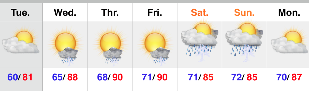
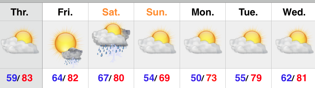
A cold front remains off to our northwest as we type this and big storms are firing across northern portions of the state. We’ll keep a close eye on those as they move southeast tonight and begin to pick up more forward momentum in the coming hours. They’ve had a history of producing damaging hail. Remain weather-aware this evening.
Thankfully we’ll begin to inject a drier air mass (briefly) into the region Tuesday. A nice day is coming with lower humidity. Most of the second half of the work week will also remain dry, but as humidity increases we have to mention the threat of an isolated to widely scattered storm. The big story will be the heat as highs push into the 90 degree territory. Prepare to sweat!
Better chances of showers and thunderstorms will push back into the region over the upcoming weekend. We’re not forecast a complete washout either Saturday or Sunday, but with a very humid air mass in place, any shower or storm that develops will have the capability of producing torrential downpours.
Upcoming 7-Day Rainfall Potential: 1.5″ – 2.5″
Permanent link to this article: https://indywx.com/storms-tonight-heat-builds-this-week/
 Highlights:
- More like summer
- Mostly dry weekend
- Keeping a close eye on Sunday night storm threat
- Unsettled to open the week
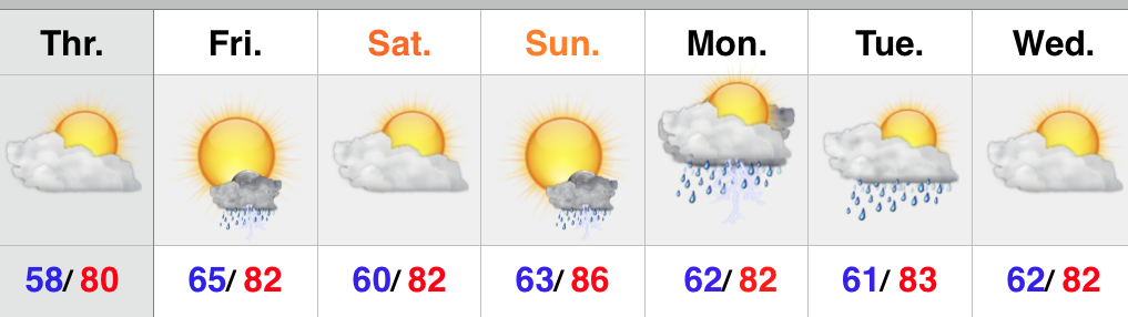
The story to wrap up the work week will be one much more typical of early June- warmer days are on deck with increasing humidity. The combination of the increasingly muggy air mass coupled with a weak upper level disturbance, could ignite a shower or storm Friday. Most of the day will be dry, however. The upcoming weekend will feature beautiful weather conditions- dry and warm to hot. We continue to watch a storm complex that could deliver a round of strong to severe cells (damaging straight line winds being the biggest concern) Sunday evening and night. We’ll have to tighten up potential timing as we progress closer to Sunday, but think most of the daytime hours will be dry. Early next week will likely open a bit unsettled.
Upcoming 7-Day Rainfall Potential: 0.50″ – 0.75″
Permanent link to this article: https://indywx.com/warmer-days-continuing-to-watch-sunday-evening/
 Highlights:
- Unseasonably chilly air begins to moderate
- Dry weather returns
- Eyeing the next cold front late in the weekend
The past couple of days have felt more like late spring or fall rather than the first day of meteorological summer (June, July, August). No need to fret, however, as milder air will return beginning Tuesday afternoon…after another very chilly start. The next couple of days will feature plenty of sunshine! Enjoy! Moisture will slowly begin to increase to end the week and an isolated to widely scattered storm chance will accompany the warmer, more humid air. Best rain and storm chances look to come Sunday as a cold front moves closer. Drier and cooler air will work back into the region Monday evening.
Upcoming 7-Day Rainfall Potential: 0.50″ – 0.75″
Permanent link to this article: https://indywx.com/chilly-now-but-warmer-days-coming/
 Highlights:
- Unseasonably cool to open the new week
- Dry pattern most of the week
- Storm chances increase late week
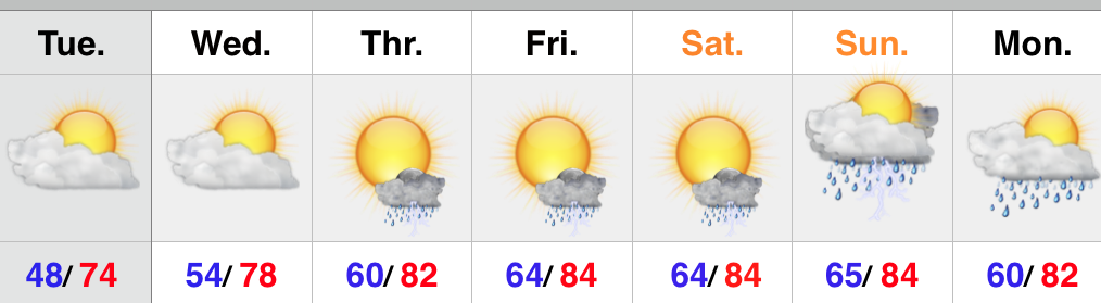
Beneficial rains fell across the area Saturday and today we’re left with a cloudy, drizzly, and much cooler regime. It certainly won’t feel like May 31st and June will also open on a much cooler than normal note. Jackets will be required this afternoon. Most of the upcoming week will feature dry skies along with a warming trend once to mid week. Moisture will increase Thursday and we’ll introduce a chance of scattered thunderstorms Thursday into Friday.
Upcoming 7-Day Rainfall Potential: 0.25″ – 0.75″
Permanent link to this article: https://indywx.com/much-cooler-today/
 Highlights:
- Less humid today
- Best rain chances Saturday, but plenty of dry time too
- Much cooler early next week
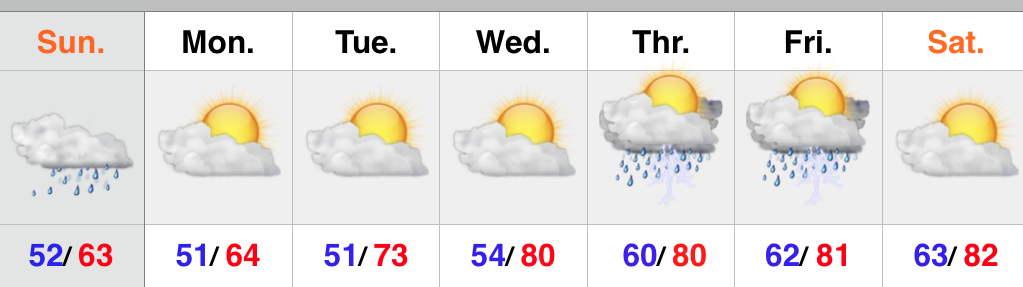
High pressure and a northeast flow will help provide a much less humid feel today, but it’ll still be warm. Moisture will slowly increase again Friday and isolated to widely scattered storm coverage will return. Best rain and storm chances will arrive Saturday afternoon and evening as a cold front passes through the region, but we want to make sure we also stress there will be plenty of dry time, as well. The big story early next week will be a MUCH cooler air mass moving into the region. Models are behaving in an inconsistent manner Sunday in regards to the timing and position of the frontal passage. As of now, we’re leaning towards the drier solutions, but stay tuned.
Upcoming 7-Day rainfall potential: 1″ to 1.2″
Permanent link to this article: https://indywx.com/less-humid-today/
