Extended Stretch Of Raw Conditions…
 Highlights:
- Periods of rain
- Turning colder
- Finally begin to dry things out
We sure hope you enjoyed those pleasant conditions on Thanksgiving Day, as rain (and eventually colder air) is settling in for the long haul.
The overall set-up shows a cold front slicing it’s way through the mid section this morning. This front will continue to slowly settle southeast and much colder air will “ooze” into the area directly behind the boundary later tonight and Saturday. Unfortunately, once the front passes to our south, additional disturbances will move along the front and enhance rain across our area from time to time over the weekend.
Here’s a snap shot, courtesy of Weatherbell.com, of what we the surface map/ simulated radar may look like as we rumble through the Thanksgiving weekend.


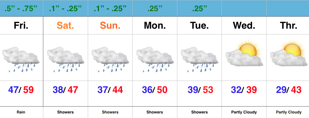
 As mentioned above, the temperature story will also be a focal point later tonight. Notice the incredible difference within just a matter of miles as we go deeper into the weekend. While central IN will be in the “transition” period tonight, all of the area will be on the cold side of the boundary Saturday. That forecast high in the upper 40s that you see above in our 7-day will be at midnight as most of tomorrow will be in the upper 30s/lower 40s.

 We’ll continue to deal with unsettled and rather “raw” conditions into the early portions of next week, but we should finally be able to shake the damp conditions by Wednesday. We’ll continue to keep a close eye on yet another system late next week, but models keep this storm to our south as of now. Stay tuned.


